Introduction
The process of transportation planning entails developing a transportation plan for an urban region. It is an ongoing process that seeks to address the transport needs of the inhabitants of the area, and with the aid of a process of consultation with all relevant groups, strives to identify and implement an appropriate plan to meet these needs.
The process takes place at a number of levels. At an administrative/political level, a transportation policy is formulated and politicians must decide on the general location of the transport corridors/networks to be prioritised for development, on the level of funding to be allocated to the different schemes and on the mode or modes of transport to be used within them.
Below this level, professional planners and engineers undertake a process to define in some detail the corridors/networks that comprise each of the given systems selected for development at the higher political level. This is the level at which what is commonly termed a ‘transportation study’ takes place. It defines the links and networks and involves forecasting future population and economic growth, predicting the level of potential movement within the area and describing both the physical nature and modal mix of the system required to cope with the region’s transport needs, be they road, rail, cycling or pedestrian-based.
At the lowest planning level, each project within a given system is defined in detail in terms of its physical extent and layout. In the case of road schemes, these functions are the remit of the design engineer, usually employed by the roads authority within which the project is located.
The remainder of this chapter concentrates on systems planning process, in particular the travel data required to initiate the process, the future planning strategy assumed for the region which will dictate the nature and extent of the network derived, a general outline of the content of the transportation study itself and a description of the decision procedure which guides the transport planners through the systems process.
Travel data
The planning process commences with the collection of historical traffic data covering the geographical area of interest. Growth levels in past years act as a strong indicator regarding the volumes one can expect over the chosen future time, be it 15, 20 or 30 years. If these figures indicate the need for new/upgraded transportation facilities, the process then begins of considering what type of transportation scheme or suite of schemes is most appropriate, together with the scale and location of the scheme or group of schemes in question.
The demand for highway schemes stems from the requirements of people to travel from one location to another in order to perform the activities that make up their everyday lives. The level of this demand for travel depends on a number of factors:
· The location of people’s work, shopping and leisure facilities relative to their homes
· The type of transport available to those making the journey
· The demographic and socio-economic characteristics of the population in question.
Characteristics such as population size and structure, number of cars owned per household and income of the main economic earner within each household tend to be the demographic/socio-economic characteristics having the most direct effect on traffic demand. These act together in a complex manner to influence the demand for highway space.
As an example of the relationship between these characteristics and the change in traffic demand, let us examine Dublin City’s measured growth in peak travel demand over the past ten years together with the levels predicted for the next ten, using figures supplied by the Dublin Transport Office (DTO) in 2000. Table 1.1 shows that between 1991 and 1999 peak hour demand grew by 65%.
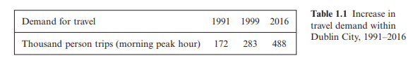
It has been predicted by DTO that between 1999 and 2016 a further 72.4% of growth will take place.
The cause of these substantial increases can be seen when one examines the main factors influencing traffic growth – population, number of cars per household and economic growth. Between 1991 and 1999, the population within the area increased by just over 8%, and car ownership by 38.5%, with gross domestic product increasing to 179% of its 1991 value. DTO have predicted that, between 1999 and 2016, population will increase by 20% and car ownership by 40%, with gross domestic product increasing to 260% of its 1991 value (see Table 1.2)
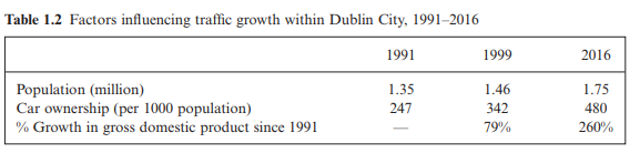
The significant growth indicated in Table 1.2 is consistent with the past recorded and future predicted traffic demand figures given in Table 1.1. High levels of residential and employment growth will inevitably result in increased traffic demand as more people link up to greater employment opportunities, with the higher levels of prosperity being reflected in higher levels of car ownership. Increasing numbers of jobs, homes, shopping facilities and schools will inevitably increase the demand for traffic movement both within and between centres of population.
On the assumption that a road scheme is selected to cater for this increased future demand, the design process requires that the traffic volumes for some year in the future, termed the design year, can be estimated. (The design year is generally taken as 10–15 years after the highway has commenced operation.) The basic building block of this process is the current level of traffic using the section of highway at present. Onto this figure must be added an estimate for the normal traffic growth, i.e. that which is due to the year-on-year annual increases in the number of vehicles using the highway between now and the design year. Table 1.1 shows the increase in vehicle trips predicted within the Dublin Region for the first 16 years of the new millennium. Onto these two constituents of traffic volume must be added generated traffic – those extra trips brought about directly from the construction of the new road. Computation of these three components enables the design-year volume of traffic to be estimated for the proposed highway. Within the design process, the design volume will determine directly the width of the travelled pavement required to deal with the estimated traffic levels efficiently and effectively.


Comments are closed