Construction of highways and railways is challenging around mountains and steep slopes. Each require special study by geologists and geotechnical engineers. Through geotechnical analysis, slopes are identified that are critical and require special protection.
The “Rockfall Hazard Rating System” for the Federal Highway Administration was introduced by the Oregon State Highway Division. It is used to define the overall stability of slopes along mountainsides against major sliding or toppling failures in order to protect the highway below from known hazards through various methods. However, analysis of hundreds of miles of mountain highway can be more difficult than rocket science.
In this article we take a look at the important things done under this rating system in regard to determining slopes that are hazardous and require immediate remedial work. You can also use the table in the image given below for the exact ratings of all the factors of this rating system.
Slope Height
Slope height is an important measure of risk because rocks present on the higher slopes have higher potential energy. Measuring slope height requires determining only the vertical height of the slope (in place of the slope distance) or measuring the highest point from where rockfall can be reasonably expected. There might be some cases where rocks are coming from a slope present above the roadway cut. In this situation, add the cut height to the original height of the slope.
Ditch Effectiveness
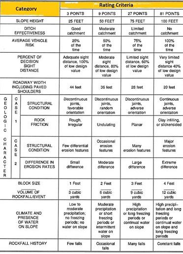
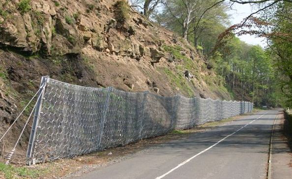
“Ditch” is the area in between the slope and the roadway. The ditch effectiveness is defined as ability of the ditch to prevent falling rock from reaching the road. There are certain factors that need to be considered for measuring ditch effectiveness.
Slope height and its angle
Slope irregularities
Quantity of the rockfall
Anticipated size of the block
Parameter and shape of the ditch
Measuring slope irregularities is important because it can increase or decrease the speed of falling rocks and there would be more tendency of rocks reaching the road.
Percent of Decision Sight Distance
Sight distance is the length at which an obstacle of a specific height is visible to the driver. The percent decision sight distance is the measurement in feet that is used to determine from what distance a normal driver can make an instantaneous decision if any obstacle comes in front of him.
It is important because curves of the roadways along the mountains can limit the ability of a driver to notice rocks present on the road.
Geologic Character
As the name says, it defines the geologic character of the slopes. These are classified in two cases. The first case includes the structural conditions such as adhesive or continuous joints present in the slopes, rock friction angle, hydrostatic head if water is present, and other discontinuities. Furthermore, the second case includes slopes having differential erosions or overstepped slopes.
Measurement of rock friction is also important determining the potential of the rocks to move over one another.
Quantity of Rockfall per Event
This rating determines what type of rockfall may most commonly occur. For example, if rocks fall individually, considering the sizes of the rocks is required. If a number of small and large sized rock fall, use the mass of the fallen rocks in the last event to determine the rating. Usually these measurements can be easily determined from the maintenance history. However, if there is no event history, estimate it through observing the conditions of the slope. This factor is also beneficial for future remedial measures.
Climate and the Presence of Water
Studying the climate and the presence of water in the slope is essential. This is because water and freeze cycles contribute an important role in rock movement. If the area gets less than twenty inches rain per year, it is called a low precipitation area; if the value is more than fifty inches, it is then called a high precipitation area. The impact of freezing or thaw cycles can be determined by the freezing conditions of the area.
Other Important Parameters
The rockfall hazard rating also includes the width of the roadway. This measurement is appropriately called “Roadway Width” and defines the maneuvering room for a driver to avoid rockfall. If the width is variable, consider the minimum width of the roadway for this rating.
The “Average Vehicle Risk” rating represents the average time of which a vehicle will be present in the hazard zone. It is based on factors like daily traffic and the posted speed limit in an area.
Next is “Difference in Erosion Ratings.” This measurement defines common physical and chemical erosion processes happening in the slope. The effect of human action is also a factor to consider into it. The difference in erosion rates explains how quickly erosion is taking place at the particular slope.
All the above points are important and essential to determine for the Federal Highway Administration’s rating system for rockfall hazards. However, there is one more point to consider, and that is the rockfall history of slopes. This is because historical data directly represents which slopes are very hazardous and require remedial work. Again, the maintenance officer is the best person for getting the history of such events.