
In compass survey chain or tape is used for linear measurement. If the surveying starts from a station, goes round an area and ends at the starting station it is called closed traverse. If survey starts from a point, goes along a number of interconnected lines and ends at some other point it is called as open traverse. Closed traverse is used for preparing plan of an area while open traverse is useful in the road, rail or canal projects. The following are required for chain and compass survey:
(i) Compass and stand
(ii) Chain and tape
(iii) 10 arrows
(iv) 5 to 6 ranging rods
(v) Ranging poles
(vi) Pegs and hammer
(vii) Plumb bobs
(viii) Line ranger, cross staff etc.
Field Work
Field work involves:
(i) Reconnaissance survey
(ii) Preparation of location sketches of stations
(iii) Measurement of directions
(iv) Measurement of lengths and offsets, and
(v) Recording measurements.
(i) Reconnaissance Survey:
The entire area to be surveyed is inspected to select survey stations.Important points to be considered in selecting stations are:
(a) Adjacent stations should be intervisible.
(b) Lines to be chained should be free of obstacles.
(c) Number of survey lines should be minimum.
(d) Survey lines should run close to the important objects, so that offset lengths are small. An index map is prepared with pencil and stations are marked. If necessary, changes may be made in survey lines and corresponding changes in the index plan.
Location Sketches Before commencing surveying a line, the location sketches of the stations of that line should be prepared. At the beginning of the field book few pages should be reserved for drawing location sketches.
Direction Measurement
The following precautions should be taken in measuring the direction of a survey line with compass.
(a) Centre the compass on the station correctly.
(b) Level the compass and ensure needle is free to move.
(c) Take the reading only after vibration of graduation circle/needle is stopped. Use the knob, if necessary.
(d) Gently tap the top of the glass of compass to remove sluggishness of the needle and take the reading after vibration stops.
(e) While taking reading parallax should be avoided.
(f) Care should be taken to keep away steel and iron objects like key bunch, metal framed spectacles, iron buttons, chain, arrows etc.
(g) If handkerchief is used to clean top of glass of campass, the glass is charged with electricity. As a result of it local attraction is induced. To avoid this problem apply moist fingers to clean the glass.
(h) If the compass is not in use, fold the prism and object vane on the top of glass plate, so that needle is lifted from the pivot to avoid unnecessary wear of the pivot.
(i) For all survey lines fore bearings and back bearings should be taken. If any other survey station is visible, bearing should be taken to that station also, which helps in checking survey work.
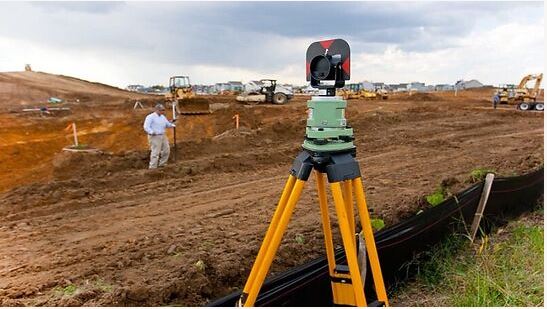
Plane Table Surveying
In this method of surveying a table top, similar to drawing board fitted on to a tripod is the main instrument. A drawing sheet is fixed on to the table top, the observations are made to the objects, distances are scaled down and the objects are plotted in the field itself. Since the plotting is made in the field itself, there is no chance of omitting any necessary measurement in this surveying. However the accuracy achieved in this type of surveying is less. Hence this type of surveying is used for filling up details between the survey stations previously fixed by other methods. In this chapter, accessories required, working operations and methods of plane table surveying
are explained. At the end advantages and limitations of this method are listed.
Comments are closed