
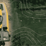
Contouring needs the determination of elevation of various points on the ground and at the same the horizontal positions of those points should be fixed. To exercise vertical control levelling work is carried out and simultaneously to exercise horizontal control chain survey or compass survey or plane table survey
is to be carried out. If the theodolite is used both horizontal and vertical controls can be achieved from the same instrument. Based on the instruments used one can classify the contouring in different groups. However, broadly speaking there are two methods of surveying:
1. Direct methods
2. Indirect methods.
Direct Methods
It consists in finding vertical and horizontal controls of the points which lie on the selected contour line. For vertical control levelling instrument is commonly used. A level is set on a commanding position in the area after taking fly levels from the nearby bench mark. The plane of collimation/height of instrument is found and the required staff reading for a contour line is calculated. The instrument
man asks staff man to move up and down in the area till the required staff reading is found. A surveyor establishes the horizontal control of that point using his instruments. After that instrument man directs
the staff man to another point where the same staff reading can be found. It is followed by establishing horizontal control. Thus several points are established on a contour line on one or two contour lines and suitably noted down. Plane table survey is ideally suited for this work. After required points are established from the instrument setting, the instrument is shifted to another point to cover more area. The level and survey instrument need not be shifted at the same time. It is better if both are nearby so as to communicate easily. For getting speed in levelling some times hand level and Abney levels are also used. This method is slow, tedious but accurate. It is suitable for small areas.
Indirect Methods
In this method, levels are taken at some selected points and their levels are reduced. Thus in this method horizontal control is established first and then the levels of those points found. After locating the points on the plan, reduced levels are marked and contour lines are interpolated between the selected points. For selecting points anyone of the following methods may be used:
(a) Method of squares,
(b) Method of cross-section, or
(c) Radial line method.
Comments are closed