
A model is defined as a simplified structure of reality, an organized principle, a synthesis of idea or a mental construct in which an actual life situation may fit in (Timmermans, 2000). Analysis of urban areas, structure of cities, urban activities and their linkages at the level of individual city has witnessed, over the years a number of improved models (Carter, 1975, Ayeni, 1979; Wegner 2001). These are the ecological/economic competition model, spatial interaction models, urban activity pattern and activity system models, spatial behavioural and microbehavioural models. The paper is viewed within the urban activity pattern and activity system models, spatial behavioural model, and microbehavioural model. These models were reviewed as a precursor to the proposed model – the model of Urban Neighbourhood Activity Centers.
Models of urban analysis
Models of urban activity pattern and activity system
Most theoretical work in the area of activity analysis stems from geography and urban planning. This is largely based on two important publications in the 1970s first by Haggerstrand (1969) and Chapin (1974). The formulation of the Activity Approach in the 1970’s was a reaction against certain weaknesses of the four stage modelling approach such as: appropriateness of the model structure, poor data quality, poor quality of the model calibration and on poor quality of forecasts made with it. (Atkins, 1987, Axhausen, 1990). Until the end of the 1980s, these questions were not thought to be serious enough to challenge the practical use of the models. The propositions of Activity Approach have been explained by Clarke (1985), Eurotopp (1989) , Axhausen (1990) and Kwan (2005) as follows: (i) activities are primary, travel is secondary (ii) activities and travel take place in time-space (iii) behaviour is influenced by space-time and other constraints (iv) household activity patterns are related to household structure (v) interactions within households change over time (vi) activity and travel behaviour is constrained by the experience of the traveler.
The ‘Activity Approach’ stands apart from the other traditions of modeling identified by Pas (1988). The concern of the ‘Activity Approach’ has not been the derivation of mathematical descriptions of human behaviour as was the concern of social physics, econometric and psychometric but to derive a modeling system to explain human spatial behaviour. One important concept that emerged from the models of urban activity pattern and activity system is the concept of “Action Space” which is the collection of all urban locations about which the individual has information and the subjective utility or preference associated with these locations (Horton and Reynolds, 1971).
The core of an individual’s action space is termed the “activity space” which is the subset of action space, that is, all locations or areas that an individual has ever visited or had direct contact with as a result of day-to-day activities. In terms of activity system, persons and firms are regarded as behavioural units, which perform some activities in some locales. The activity space is the most structured by individuals because it comprises locations, which have actually been visited. A location will change from being part of the action space to being part of the activity space once a trip has been made. The difference between activity space and action space is that although both are part of time-space environment, action space is a part of time space environment for which an individual has positive information through media, relatives or friends while activity space is a part of time- space environment frequently used.
The pattern displayed by individuals as they carry out their activities is the “activity pattern” of individuals. An Activity Pattern (AP) is an ordered sequence of activities of an individual that takes place within a space-time continuum, the activities being linked by travel. An activity pattern is, therefore, an activity programme with its schedule. An activity programme, on the other hand, is the collection of all the activity undertaken during a certain period of time irrespective of the order of their occurrence. The activity pattern is determined by individual’s propensity and opportunity to engage in particular activities (Chapin. 1974), based on “predisposition” factors (such as role obligations, traits, etc.) Associated with activity pattern are certain features, which characterized its inherent utility to the individual. These features include (i) the total number and types of activities and activity types included in activity pattern, (ii) time of the day each activity was performed, (iii) duration of each activity, (iv) activity sequence, (v) location of each activity, (vi) total distance travel, and (vii) amount of flexibility or space-time autonomy.
The advantages of the activity system approach is that it is broad: its values – behavioural – patterns framework permits the introduction of the widest range of operating factors without limiting assumptions and deductive arguments which characterized the neoclassical economic/ecology models that ignore all the competing forces and identifying only one link – that with the centre of the city.
Spatial behavioral models
The weakness of economic and ecological models gave rise to spatial behavioural models. Lloyd (1976) attempted an examination of the linkages among cognition, preferences and migration behaviour in different states in the United States of America and found a strong structural linkage among them. He concluded that, based on the three components, it is possible to predict the direction of movement in that preferred locations of cognitive space would receive larger percentages of migrants and vice-versa. Hanson (1977) revealed that when the spatial form and extent of information levels are compared with the travel patterns that emerged from the travel diary of the urban residents, it is evident that the set of locations actually contacted is but a small sub-set of the cognitive opportunity. Cadwallader (1978) used information and preference surfaces in explaining individual’s cognitive space. Preference surface reflects the varying attractiveness as a place to live in, which people attach to different locations. It was, however, discovered that the underlying structures of information and preference surfaces are more difficult to disentangle, especially in the case of information surface, and there is no evidence that these structures are strongly related.
Information about the objective environment as stored subjectively in the individual’s brain is called the cognitive constructs of the urban environment. Cognitive image is, however, different from locational schematic or mental map. The term “cognitive” is used to indicate the non-locational character of most images, and to suggest that thinking and verbal behaviour form a stronger component of cognitive images than concrete visual imagery (Wong, 1979). Cognitive affective maps are mental orderings of the environment that involve preference ratings that guide residential choice, but personal and financial considerations often preclude selection of the preferred location (Preston, 1982). Behavioural models provide psychological oriented accounts of the destination choice process in repetitive urban spatial behaviour (Pipkin, 1981).
Behavioural approach is increasingly finding a place in urban and transportation planning in an attempt to improve the policy contents of plan proposals (Chorkor, 1986a; 1987, 1988). The earlier approach of urban/transportation planners has leaned heavily towards the environmentalists’ viewpoint which, according to Herz (1982) maintains that spatial behaviour, including personal and social constraints is essentially a function of the material environment. Thus, what appears to be close to environmental deterministic view of behaviour has been jettisoned and planners are currently adopting behavioural approach, which sees the spatial structure, material environment and man as mutually interacting elements of the urban space.
Man is considered as having the ability to evaluate, interprete and react to his environment as observed and perceived. However, Lundqvist (1978) observes that existing planning models are not capable of integrating structure and behaviour in a theoretically sound way and at a level of detail that is useful for planning purposes. He suggests that it may be necessary to work with less ambitious approaches built on iteractive use of structural and behavioural models. This problems is still evident despite the fact that sophisticated techniques are being developed and employed in planning to analyse spatial behaviour (Burnett, 1977: Arad and Berechman, 1978; Smith, et al, 1982). Timmermans and Veldhuisen (1982) observe that behavioural models offer a potentially more valuable approach to predict the likely effects of physical planning schemes as compared with the gravity-type approaches. They, however, noted that behavioural models share with the gravity type models the problem of whether equations could be developed solely on the basis of policy sensitive factors or whether other influential factors should be included.
The micro-behavioral approach
The micro-behavioral approach, otherwise known as systems approach to urban activity network, seeks to explain urban spatial structure, not in a mechanistic term as done by the neo-classical economists. Rather it explains urban spatial structure, especially the interactions in an urban setting, as an interaction between population (people), activities, locations and time. This approach is different from activity system model, in the sense that it incorporates the time element and individual instance of behaviour and activity, obtained in the form of disaggregated data. The important features of this approach are (i) incorporating time as a commodity, (ii) giving new meaning to land (multiplicity of land use), (iii) perceiving people’s behaviour as linked to the ways in which they perceive space, and (iv) providing a holistic approach to urban structure. This approach of integrating individual spatial behaviour overtime was pioneered by Hãggerstrand (1969). He used a simple diagram to illustrate his concept of space-time dimensions. Hãggertrand postulated the geographers’ two-dimensional space on the surface of the earth or on the surface of a map. A line on this surface indicated movement in space but not in time. He suggested a third dimension to signify time.
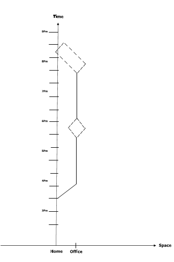
Fig. 1. Man’s Daily Space-time Dimensions. Source: Adapted from Haggerstrand (1969).
Figure 1 represents a very simple working day. Solid lines represent the path of all obligatory activities and dotted lines the prism or feasible regions of movement in periods for which there are no fixed activities. The worker is assumed to be effectively fixed at home until 7:30am to 8:00am where he can conveniently sleep and take breakfast. He must then take a direct route to work, where he is obliged to stay until lunchtime. During the lunch hour he has a certain amount of freedom; he must be back in the office exactly an hour. From 2pm until about 5pm he is again expected to stay at work. But after 5pm he has no need to be home until 7pm for supper. In this period, 5-7pm, he can stay on at work or he can go somewhere near or stop off on the way back for a drink or visit. The main feature implicit in this model of daily behaviour is the idea that certain activities are fixed in both space and time. This model (of the individual’s activity -time -space decision) is based on a set of assumptions Six of these assumptions were identified by Cullen and Godson (1975). They are: organised behaviour, the Action Space, Priorities, Constraint, Flexibility of Activities and Scheduling.
Spatial interaction function model
The Spatial Interaction Function has made it possible to recognize the interaction between people (Population), activities, locations (of the activities) and times (of the day) when the activities took place. This is not in the conventional mechanistic method, but rather in terms of attractiveness of places. Also through this modeling, it is possible to predict at any point the location and quantity of new population through what can be described as InterElement Linkages as shown in Figure 2.
| Population | Social contact (1) | ||
| Activities | Activity pattern (2) | Activity Transition (3) | |
| Locations | Individual spatial behaviour (4) | Activity Location (5) | Time (6) |
| Time | Individual Temporal behaviour (7) | Activity Timing (8) | Use Density (9) |
| Population | Activities | Locations |
Fig. 2. Inter-element Linkages. Source: Procos and Harvey, 1977
Figure 2 shows the linkages among the time and the space in which the activities of a given population take place. Linkages between population sub-groups would produce social contacts (cell 1). On the other hand, the linkages between locations and population, locations and activities and locations and locations produce individual spatial behaviour, activity location and time of day when activities take place (cells 4, 5 and 6). Finally the linkages between time and population, time and activities and time and locations produce individual temporal behaviour, activity timing and use density of land respectively (cells 7, 8 and 9).This modeling technique is thus unique and different from the conventional method which only explains linkages through origin destination using the gravity modeling technique (Abler et al, 1992, Ayeni, 1979; 1992).
The functioning model
The Function Model unlike the conventional modeling technique did not consider the attractivity of a space in a mechanistic or unidirectional way rather it recognizes attractivity in terms of interaction between population (people), location activities and times. The most important aspect of this modeling technique is its multidirectionality as shown in the Figure 4.
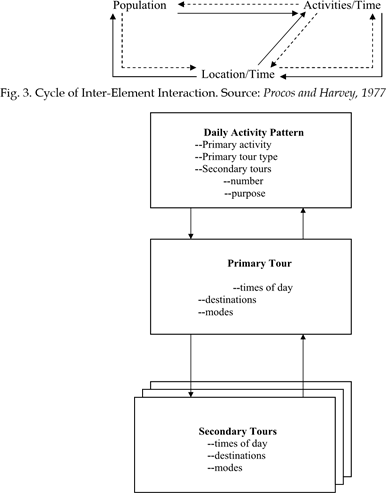
Fig. 4. The daily activity schedule. Source: Adapted from Timmermans (2000).
Recent works on time-space activity unlike the earlier ones, have been largely concentrated on modeling time-space activity pattern (Zahavi, 1978; Lantrip, 1990; Axhausen and Garling 1991; Garling, Kwan and Golledge, 1993; Vander Knaap 1996; Golledge, Kwan and Garlin 1994; Bhat, 1997; Garling, Romanes and Vilhelmson, 1996; Timpf, 2002), computational process and the application of Geographical Information System (GIS) in modeling timespace activity (Hirsh Prashkea and Akiva, 1988; Kitamira, 1988; Axhausen, 1990; Kwan, 2000; Root and Recker 1990; Timmermams 2000; Golob and Mcklally, 1995; Ben-Akiva et al 1996; Kwan, 2003, 2004, 2005; LLoyd and Shuttle 2005). For instance Ben-Akiva et al (1996) applied the daily activity schedule model to data from the Boston metropolitan area, including a 24-hour household travel diary survey collected in 1991, as well as zonal and transportation system attributes from the same time period to produce the daily activity schedule model.
The model groups the elemental decisions of the daily activity schedule into five tiers or hierarch: (a) daily activity pattern, (b) primary tour time of day, (c) primary destination and mode, (d) secondary tour time of day, and (e) secondary tour destination and mode (Fig.5).
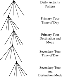
Fig. 5. The daily activity schedule. Source: Adapted from Timmermans (2000)
The choice of daily activity pattern determines the number of secondary tours in the daily activity schedule. The choice of secondary tour time, destination and mode are conditioned upon the choice of a daily activity pattern. For daily activity patterns with 2 or more secondary tours, the conditional choice probabilities of the secondary tours are mutually independent, calculated from the same models. This approach, though represent a state-ofthe art in modeling, it is, however, deficient in the sense that it ignores time and space constraints across secondary tours, but simplifies the model structure. (Timmermans, 2000)
Most of the works in developed countries especially in the United States have been in the field of transportation geography especially in the area of urban travel activity pattern and telecommuting in the city. A few of the most recent time-use studies have examined the impact of new Information Technology (IT) on people’s everyday lives. For instance, Robinson et al (1997) compared the mass media use and social life of internet users, based on a 1998 survey of 3,993 adults in the U.S. They found no significant or consistent evidence of time displacement by mass media use of social activities as a result of internet or computer use. Another study by University of California, Los Angeles Center for Communication Policy (UCLA – CCP, 2000) involving 2096 households in the U.S found that internet use has considerable impact on a person’s time use pattern and shopping behavior. The literature, although revealing about how people spend their time, have shown that studies do not explicitly incorporate the spatial dimension in their data collection procedure and analysis. The time displacement perspective therefore needs to be expanded to a space-time displacement perspective to be useful for understanding people’s activity pattern in space – time and the urban economy. The space- time displacement perspective suggests that there are distinctive geographical consequences associated with such time displacement Kwan (2000) explored and implemented the extensibility diagram as an analytical tool within a three dimensional (3D) geographical information system (GIS). Using the navigational history of a person’s web browser and data collected through personal interview, she developed a method that takes into account the multiple spatial scales and temporal complexities (simultaneity and disjuncture) involved in individual activities both in the physical and virtual worlds. Kwan (2002, 2003) also proposed a conceptual frame work of human cyberspatial behaviour based on time – geographic perspective, she argued that space-time constraint are still important even in the information age.
Although all these recent time geographical studies observed that the telecommuting did not induce a significant increase in non-work trips and activities, they also suggested that significant insights can be gained through examining the impact of new IT on people’s space time constraint, and indicated the kind of data and methods useful for geographical studies of everyday life and the urban economy (Mokhtarian, 1990; Mokhtarian et al 1995, 1999; Kwan, 2001). But as noted by Kwan (2003, 2004 and 2005); Kwan, Murray, O’Kelly and Tiefelsdorf (2003), Weber and Kwan (2002, 2003) this kind of research (IT – Cyber spatial – Time geographic research) is still uncommon in geography to date in both advanced and developing countries. This is due to the fact that the required data are complex, costly and time consuming to collect, and there are a few established methods for analyzing these complex data.
In developing countries in general and Nigeria in particular, works on urban activity linkages through time and space are rare or non-existing. The few existing works in Nigeria like those of the American and European scholars focus mainly on interaction or movement within urban areas. For instance, Fadare (1986, 1989) and Ojo (1990) examined the factors affecting household trip generation in Ibadan while Aderamo (1990, 2000, 2004) examined the impact of road development on urban expansion in Ilorin, the spatial pattern of IntraUrban trips and the role of transport factor in the structure and growth of Ilorin. AdenijiSoji (1995) also analyzed the pattern of telecommuting and intra-city travel in Ibadan. Others such as Adagbasa (1995) and Bello (1995) studied intra-pattern urban movement in Benin City. One thing that is common to all these works is that they are all carried out within the framework of transportation geography without necessarily linking movement in space with the activity of the people. Thus a study was conducted to explore the missing link between people, their activities, locations of these activities and the times of the day when these activities take place with the aim of providing information that could be used to develop a model applicable to activity location and land use planning and management in a traditional African city in transition (Adedokun, 2008, 2009). From the data collected and analyzed in the study area, about 90 percent of the respondents had their activities fixed in space especially at home/place of work and about 89 percent also had their respondents are engaged in informal sector and are self-employed. These population characteristics and the activity pattern (fixed in space and time) generated mainly home and office/work place based activities which the people have adjusted and accustomed to. The implication of this is that certain spaces would be in greater (or lesser) demand at a particular time. This forms the basis for the proposed model for this study.
A model of urban neighbourhood activity centres
Based on the foregoing, we would like to construct a generalized model of land use planning and facility location in a traditional medium size urban center using Ilorin as a case study (see Figure6).
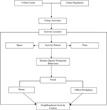
Fig. 6. A Model of Urban Neighbourhood Activity Centers. Source: O.M. Adedokun, 2009.
Figure 6 shows the linkages among population, time and space and urban activities. Given a medium size urban centre with its population, there would emerge various types of urban activity located in different parts of the city. The location of these activities would in turn generate activity pattern with space and time (or spatio-temporal) dimensions. The activity pattern itself would generate human spatio-temporal behavior. In this paper, it is shown that human behaviour in space and time is fixed. The fixity in human spatial behaviour is shared between home and office/work place. The urban neighbourhood activity centre model is of the view, therefore, that in planning for a medium size urban centre in developing world, there is the need to adopt a strategy that would incorporate the behaviour of the people. Instead of strict land use zonation approach; facilities may be located closely to or around neighborhoods where people are fixed. In this case and as demonstrated, facilities and infrastructures should be located between homes and work places. Obviously, if there is a demonstrable linkage between two activities in time, it makes sense to locate the facilities housing them in the same space so as to eliminate time and energy consuming travel.
Conclusion
Over the years, studies on urban land use have been dominated by increasing mechanistic approach. These studies have not elucidated on a better understanding on dynamic model of urban infrastructural planning. We are not oblivious of the fact that oftentimes, models showcase the peculiarity of the context within which they are produced. Also, most of the earlier models were based on experiences of European and American cities that have little or direct bearing with orthogenetic or traditional African cities in transition. There is, therefore, the need for an active involvement of those who are directly impinged upon (the people) in issues relating to land use planning and activity location. Here lies the importance of Urban Neighbourhood Activity Centers Model. This model if implemented, especially in medium sized traditional or orthogenetic cities, where modern day town planning theory is alien and unenforceable, will help to achieve efficiency and optimality in land use planning and activity location. It will also help to achieve and ensure spatial and social justice, equity and equal opportunity for all environmental (urban land users) consumers.
Although this research used disaggregated data to determine house hold activities which were latter classified into three category of activities i.e. home based, office/work place and outdoor based activities respectively and the linkages between the populations these activities, their location in time and space. Future research frontiers could pick on any of the three groups (home, workplace and outdoor activities) and further disaggregate them to determine their locations, time spent on each and the level of linkages between the activities. Furthermore, future research could focus on larger cities that are not necessarily state capitals (even two adjacent or contiguous cities (Conurbations) and compare their spatiotemporal activity linkages for the purpose of achieving optimality in urban land use planning and management.