An abrupt and tremendous release of energy stored in the rocks and the earth’s crust through the action of tectonic process is described as an earth quake. Some areas on the planet earth are so located that more than one tectonic plate constantly change against one another and an earthquake can result when one or more of these plates move against the others at high speed. In certain regions of earth, earth quakes occur with regularity. In India,Assam and the Himalayan regions are more infested with earthquakes. Earthquake that occurred in 2001 in Gujarat taking a toll of 30,000 people was major one. The intensity of earth quake is measured on Richter scale. As of now there is no way of predicting an earth quake. Earthquake by themselves do not cause casualties but the houses collapse due to poor construction. The construction of quake-proof houses may reduce human loss but it may be economically difficult for poor countries. The Government of countries which are quake prone should ensure that the infrastructure could withstand earth quakes.
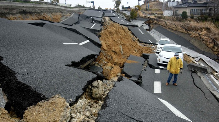
On 26 January 2001 an earthquake registering 7.9 on the Richter scale
devastated the Indian state of Gujurat. It was the second largest recorded earthquake in India, the largest being in 1737, and was the worst natural disaster in India in more than 50 years. The earthquake struck at approximately 8.46am local time, its epicentre located 80 kilometres north-east of the city of Bhuj .The place in the earth’s crust where an earthquake occurs is known as the focus. The epicentre of an earthquake is the place directly above the focus. The shock waves or tremors from the Gujurat earthquake lasted about two minutes, followed by aftershocks for more than a month. The scale of the impact of the earthquake is almost impossible to comprehend. The shock or seismic waves spread out in a 700 kilometre circumference from the epicentre, and within this
area the devastation was immense. There were more than 20,000 deaths and 167,000 people injured. Four districts of Gujurat lay in ruin and altogether, 21 districts were affected. Around 300,000 families and at least 3 million children aged 14 and under were affected. Around 600,000 people were left homeless. In the city of Bhuj, more than 3,000 inhabitants of the city lost their lives, the main hospital was crushed and close to 90% of the buildings was destroyed. Nothing was left of the town of Bhachau. The town resembled a quarry. Few structures remained standing.
Cyclones: Cyclone is a meteorological phenomena of intense depressions forming over the open oceans and moving towards the land on the shore. In reaching the shores, it moves into the interior of the land or along the shorelines. The cyclone once formed may be active from days to weeks and affects many areas Globally North Westt pacific regions are more prone to cyclones. The Indian Ocean is one of the six major cyclone prone regions of the world. India has a long coastline of 5700 kms, which is exposed to tropical cyclones arising in the Bay of Bengal and the Arabian Sea. The eastern coastline is more prone to cyclones as it is hit by about 80 percent of the total cyclones generated in the region. In India, cyclones originating from Bay of Bengal are more in number and intensity. In India, cyclones occur usually between April and May and also between October and December. The damage depends on the intensity of cyclone, the damage to human life, crops, settlements, roads, communications, tanks, canals, and livestock; sometimes, their occurrence slow down the developmental activities of the areas.
Mitigation measures are:
- Installation of early warning systems
- Developing communication infrastructure
- Developing shelter belts
- Construction of permanent houses
- Training and education on land use control and settlement planning.
LAND SLIDES: are recurring phenomena in Himalayan region. and western ghats It is a geological process which includes a wide range of mass movements, such as rock falls, deep failure of slopes and shallow debris flows. Although gravity action on an over steepened slope is the primary reason for a landslide, there are other contributing factors affecting the original slope stability erosion by rivers, glaciers, or ocean waves create over steepened slopes. In recent years, however, intensive construction activity and the destabilizing forces of nature have aggravated the problem. Landslides occur as a result of changes on the slope, sudden or gradual either in its composition, structure, hydrology or vegetation. The changes can be due to geology, climate, weathering, changing land use and earth quakes.
- Rock and soil slopes are weakened through saturation by snowmelt or heavy rains, earthquakes create stresses that make weak slopes fail.
- Volcanic eruptions produce loose ash deposits,
- Vibrations from traffic, machinery, thunder and blasting can trigger weak slopes
- Groundwater pressure acting to destabilize the slope
- Excess weight from accumulation of rain or snow, stockpiling of rock or ore
from waste piles, or from man- made structures may stress weak slopes to failure and other structures.
Measures to prevent land slides are drainage measures, erosion control measures such as bamboo check dams, terracing, jute and coir netting and rock fall control measures such as grass plantation, vegetated dry masonry walls, preventing deforestation and improving forestation. A significant reduction in the hazards caused by land slides can be achieved by preventing the exposure of population and by physically controlling the land slides.
TSUNAMI The term Tsunami comes from the Japanese language, meaning harbor (tsu) and wave (nami). A Tsunami is generated when the sea floor abruptly deforms and vertically displaces the overlying water. It is the wave disturbance that rapidly displaces a large mass of water like an under sea earth quake, volcanic eruption or submarine land slide. Tectonic earthquakes are a particular kind of earthquakes that are associated with earth’s crustal deformation; when these earthquakes occur beneath the sea, the water above the deformed area is displaced from its equilibrium position. Waves are formed as the displaced water mass, which acts under the influence of gravity attempts to regain its equilibrium. When large areas of the sea floor elevate or subside, a tsunami can be created. Tsunami wave can travel at the speed of a commercial jet plane, over 800 km/h. they can move from one side of the pacific ocean to the other in less than a day. The waves can be extremely dangerous and damaging when they reach the shore. The wave travels across the ocean at speed of 500-1000 km/ha. As the wave approaches the land, it compresses some times upto a highest of 30mts and the sheer weight of water is enough the crush the objects in its path, often reducing the building to their foundations and scouring exposed ground to the bed rock. When there is a tsunami warning:
1. If you are at home and there is a tsunami warning, you should make sure your entire family is aware of the tsunami. Your family should evacuate your house if you live in a tsunami evacuation zone.
2. If you are at the beach or near the ocean and you feel the earth shake, move immediately to higher ground. Do not wait for a tsunami warning to be announced.
3. If you are on a ship or boat, do not return to port if you are at sea and a tsunami warning has been issued for your area. Tsunami can cause rapid changes in water level and unpredictable dangerous current in harbours and ports.
On the morning of Sunday, 26 December 2004, there was a severe earthquake in the Indian Ocean off the coast of northern Sumatra, Indonesia. The earthquake measured 9.0 on the Richter scale and was followed by aftershocks ranging from 6.3 to 7.0 in severity in a zone 1,000 kilometres north to the Andaman Islands. The underwater earthquake also resulted in a powerful tsunami (‘soo-na-mi’, from the Japanese words meaning ‘harbour wave’). The wave travelled quickly under the ocean, building to a wall of water up to 10 metres high when it reached the shallow coastal waters and causing massive destruction when it hit land. Without an effective warning system and disaster plan, many people did not know to move quickly to higher ground to escape the wave and its load of debris. In some places the sea receded for hundreds of metres before the wave rushed in. Curious people looking at this strange occurrence from the beaches did not recognise this as a sign of danger, and as a result were killed by the tsunami. The tsunami caused extraordinary damage. The death toll was put at roughly 187,000, with nearly 43,000 missing and many hundreds of thousands injured and suffering trauma and the grief of losing family members, their homes and their livelihoods. Countries lost people
with the knowledge and skills that were needed for their ongoing development. Roads, bridges, water and electricity supplies, health centres and schools were destroyed. The landscape was altered unrecognisably, with some areas lifted high out of the water while others were washed entirely away. Debris and waste were scattered widely and salt inundated farmland and underground water supplies.
One of the most severely affected areas was that closest to the epicentre, the province of Aceh on Sumatra,Indonesia. More than 130,000 people died and 36,786 were missing. The highest tolls were among the women and children who were in the low lying coastal areas while their husbands were at sea fishing. Over 800 kilometres of coast was severely affected, often up to five kilometres inland. At least 654 villages were damaged or destroyed, more than 500,000 people lost their homes, and more than 150,000 children were left without schools. To add to the devastation an earthquake measuring 8.7 on the Richter scale struck the west coast of Sumatra near the island of Nias on 28 March 2005.