
The most commonly used plane table It consists of a well-seasoned wooden table
Top mounted on a tripod. The table top can rotate about vertical axis freely. Whenever necessary table can be clamped in the desired orientation. The table can be levelled by adjusting tripod legs.
The following accessories are required to carry out plane table survey:
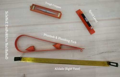
1. Alidade
2. Plumbing fork with plumb bob.
3. Spirit level
4. Trough compass
5. Drawing sheets and accessories for drawing.
Alidade
It is a straight edge ruler having some form of sighting device. One edge of the ruler is bevelled and is graduated. Always this edge is used for drawing line of sight. Depending on the type of line of sight there are two types of alidade:
(a) Plain alidade
(b) Telescopic alidade
Plain Alidade: A sight vane is provided at each end of the ruler. The vane with narrow slit serves as eye vane and the other with wide slit and having a thin wire at its centre serves as object vane. The two vanes are provided with hinges at the ends of ruler so
that when not in use they can be folded on the ruler. Plain alidade is not suitable in surveying hilly areas as the inclination of line of sight in this case is limited.
Telescopic Alidade: It consists of a telescope mounted on a column fixed to the ruler The line of sight through the telescope is kept parallel to the bevelled edge of the ruler. The telescope is provided with a level tube and vertical graduation arc. If horizontal sight is required bubble in the level tube is kept at the centre. If inclined sights are required vertical graduation helps in noting the inclination of the line of sight. By providing telescope the range and the accuracy of line of sight is increased.
Plumbing Fork and Plumb Bob
Plumbing fork is a U-shaped metal frame with a upper horizontal arm and a lower inclined arm. The upper arm is provided with a pointer at the end while the lower arm is provided with a hook to suspend plumb bob. When the plumbing fork is kept on the plane table the vertical line (line of plumb bob) passes through the pointed edge of upper arm. The plumb bob helps in transferring the ground point to the drawing sheet and vice versa also.
Spirit Level
A flat based spirit level is used to level the plane table during surveying .To get perfect level, spirit level should show central position for bubble tube when checked with its positions in any two mutually perpendicular direction.
Trough Compass
It consists of a 80 to 150 mm long and 30 mm wide box carrying a freely suspended needle at its centre At the ends of the needle graduations are marked on the box to indicate zero to five degrees on either side of the centre. The box is provided with glass top to prevent oscillation of the needle by wind. When needle is centred (reading 0–0), the line of needle is parallel to the edge of the box. Hence marking on the edges in this state indicates magnetic north–south direction.
Drawing Sheet and Accessories for Drawing
A good quality, seasoned drawing sheet should be used for plane table surveying. The drawing sheet may be rolled when not in use, but should never is folded. For important works fibre glass sheets or paper backed with thin aluminium sheets are used. Clips clamps, adhesive tapes may be used for fixing drawing sheet to the plane table. Sharp hard pencil, good quality eraser, pencil cutter and sandpaper to keep pencil point sharp are other accessories required for the drawing work. If necessary, plastic sheet should be carried to cover the drawing sheet from rain and dust.
WORKING OPERATIONS
After fixing the table top to the stand and drawing sheet to the table, the following operations are to be carried out before map making:
1. Centering
2. Levelling
3. Orientation.
Centering
Centering is the process of setting the plane table on the point so that its plotted position is exactly over the position on the ground. This is achieved by moving the legs of the tripod and checking the position of the point on the ground and on the paper with the help of plumbing fork and plumb bob.
Levelling
The level of the plane table should be ensured in two positions of spirit level which are at right angles to each other. The legs of tripod are moved radially or along the circumference to adjust the plane table and get levelled surface.
Orientation
Orientation is the process of setting plane table over a station such that all the lines already plotted are parallel to corresponding lines on the ground. Accuracy of plane table survey mainly depends upon the accuracy of orientation of plane table at each station point. It can be achieved by any one of the following methods:
(a) using trough compass
(b) by backsighting
(c) by solving two point or three point problems.
The first two methods are commonly used while the third method is used occationally. The third method is explained under the article methods of plane tabling by resection.
(a) Orientation Using Trough Compass: When the survey work starts, the plane table is set on first station and the table is oriented by rough judgement such that the plotted position of the area falls in the middle portion of the paper. Then the table is clamped and the north direction is marked on right hand side top corner of drawing sheet. Trough compass is used to identify north direction. This orientation is to be maintained at all subsequent stations. After centering and levelling the table trough compass is kept along the marked north direction and the table is rotated to get freely suspended magnetic needle centred. After achieving it the table is clamped.
This method of orientation is considered rough, since the local attraction to magnetic needle affects the orientation. This method is used as preliminary orientation and finer tuning is made by observing the already plotted points.
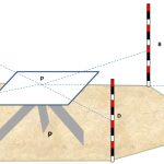
(b) Orientation by BackSighting: It is the commonly used method in plane table surveying. After completing surveying from plane table set at A, if table is to be shifted to next station B, a line is drawn from the plotted position of station A towards station B. Then distance AB is measured, scaled down and plotted position of station B is obtained. Then table is shifted to station B, centred, levelled. Then keeping alidade along BA, station A is sighted and the table is clamped. Thus the orientation of the table is achieved by back sighting. Orientation may be checked by observing already plotted objects.