Wreck Pond is a tidal pond located on the coast of the Atlantic Ocean in southern Monmouth County, New Jersey. The 73-acre pond, which was originally connected to the sea by a small and shifting inlet, got its name in the 1800s due to the numerous shipwrecks that occurred at the mouth of the inlet. The Sea Girt Lighthouse was built to prevent such accidents. In the 1930s, the inlet was filled in and an outfall pipe was installed, thus creating Wreck Pond. The outfall pipe allowed limited tidal exchange between Wreck Pond and the Atlantic Ocean.
 In the 1960s, Wreck Pond flourished with wildlife and was a popular destination for recreational activities with tourists coming to the area mainly from New York City and western New Jersey. In the early spring, hundreds of river herring would migrate into Wreck Pond, travelling up its tributaries — Wreck Pond Brook, Hurleys Pond Brook and Hannabrand Brook — to spawn. During the summer, the pond was bustling with recreational activities like swimming, fishing, and sailing.
Over time, however, the combination of restricted tidal flow and pollution, attributable to increased development of the watershed, led to a number of environmental issues within the watershed, including impaired water quality, reduced fish populations, and flooding.
Throughout the Wreck Pond watershed, high stream velocities during flood conditions have caused the destabilization and erosion of stream banks, which has resulted in the loss of riparian vegetation and filling of wetlands. Discharge from Wreck Pond during heavy rains conveys nonpoint source pollutants that negatively impact nearby Spring Lake and Sea Girt beaches resulting in beach closings due to elevated bacteria counts. Watershed erosion and sediment transported with stormwater runoff has also contributed to excessive amounts of sedimentation and accumulations of settled sediment, not only within Wreck Pond, but at the outfall pipe as well. This sediment further impeded tidal flushing and the passage of anadromous fish into and out of Wreck Pond.
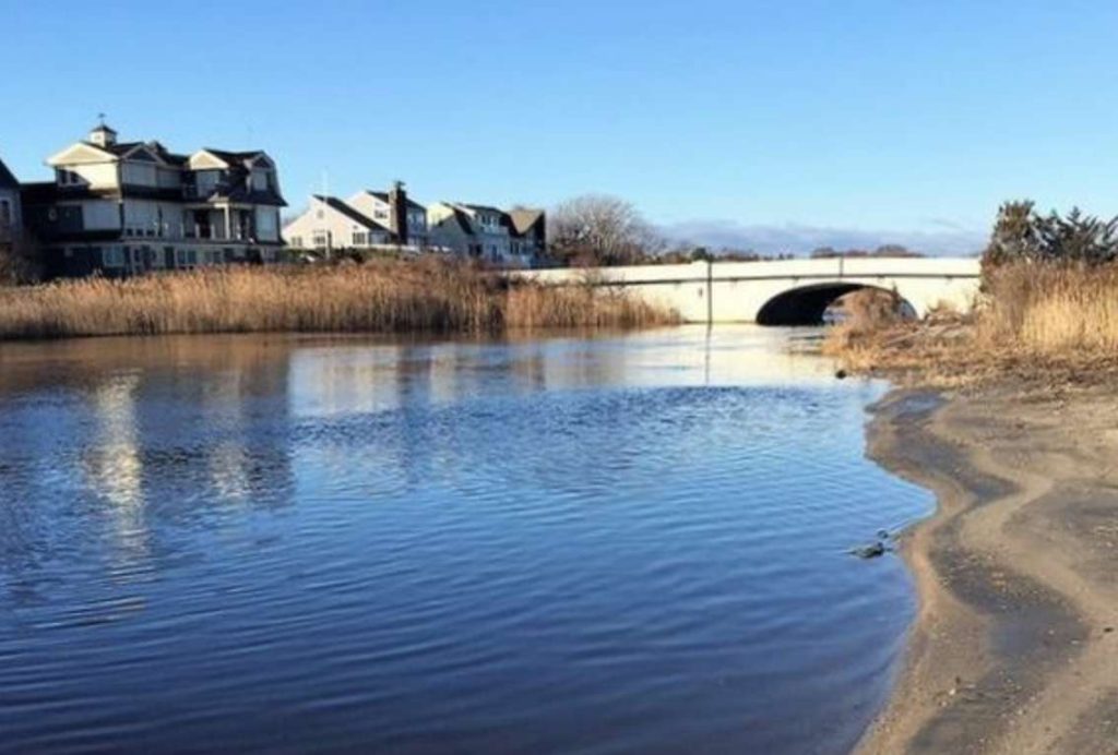
 In 2012, Hurricane Sandy caused wide-spread destruction throughout New Jersey and the entire eastern seaboard. The storm event also caused a major breach of the Wreck Pond watershed’s dune beach system and failure of the outfall pipe. The breach formed a natural inlet next to the outfall pipe, recreating the connection to the Atlantic Ocean that once existed. This was the first time the inlet had been open since the 1930s, and the reopening cast a new light on the benefits of additional flow between the pond and the ocean.
Hurricane Sandy sparked a renewed interest in reducing flooding impacts throughout the watershed, including efforts to restore the water quality and ecology of Wreck Pond. The breach caused by Hurricane Sandy was not stable, and the inlet began to rapidly close due to the deposition of beach sand and the discharge of sediment from Wreck Pond and its watershed.
 Princeton Hydro and HDR generated the data used to support the goals of the feasibility study through a USACE-approved model of Wreck Pond that examined the dynamics of Wreck Pond along with the water bodies directly upland, the watershed, and the offshore waters in the immediate vicinity of the ocean outfall. The model was calibrated and verified using available “normalized” tide data. Neighboring Deal Lake, which is also tidally connected to the ocean by a similar outfall pipe, was used as the “reference” waterbody. The Wreck Pond System model evaluated the hydraulic characteristics of Wreck Pond with and without the modified outfall pipe, computed pollutant inputs from the surrounding watershed, and predicted Wreck Pond’s water quality and ecological response. The calibrated model was also used to investigate the effects and longevity of dredging and other waterway feature modifications.
 As part of the study, Princeton Hydro and HDR completed hazardous, toxic, and radioactive waste (HTRW) and geotechnical investigations of Wreck Pond’s sediment to assess potential flood damage reduction and ecological restoration efforts of the waterbody. The investigation included the progression of 10 sediment borings conducted within the main body of Wreck Pond, as well as primary tributaries to the pond. The borings, conducted under the supervision of our geotechnical staff, were progressed through the surgical accumulated sediment, not the underlying parent material. Samples were collected for analysis by Princeton Hydro’s AMRL-accredited (AASHTO Materials Reference Library) and USACE-certified laboratory. In accordance with NJDEP requirements, sediment samples were also forwarded to a subcontracted analytical laboratory for analysis of potential nonpoint source pollutants.
In the geotechnical laboratory, the samples were subjected to geotechnical indexing tests, including grain size, organic content, moisture content, and plasticity/liquid limits. For soil strength parameters, the in-field Standard Penetration Test (SPT), as well as laboratory unconfined compression tests, were performed on a clay sample to provide parameters for slope stability modeling.

The culvert construction and sediment dredging were completed at the end of 2016. Continued restoration efforts, informed and directed by the data developed through Princeton Hydro’s feasibility study, are helping to reduce the risk of flooding to surrounding Wreck Pond communities, increase connectivity between the pond and ocean, and improve water quality. The overall result is a healthier, more diverse, and more resilient Wreck Pond ecosystem.
During the time of the progression of study by the USACE, the American Littoral Society and the towns of Spring Lake and Sea Girt were also progressing their own restoration effort and completed the implementation of an additional culvert to the Atlantic Ocean. The American Littoral Society was able to utilize the data, analysis, and modeling results developed by the USACE to ensure the additional culvert would increase tidal flushing and look to future restoration projects within Wreck Pond.

American Littoral Society