
A commuter sees a flooded underpass on the way to work. A public works crew receives calls about a street that is too hot to walk across in midsummer. At a water utility, operators watch reservoir levels after a season of irregular rain.
These are not separate problems. They are connected outcomes of climate hazards meeting infrastructure that was often designed around historical conditions: familiar rainfall patterns, expected temperatures, and stable coastlines.
Cities cannot rebuild every pipe, bridge, road, and drainage channel at once. They need ways to see trouble earlier, test options before construction, and direct limited funds toward the failures that would cause the greatest harm.
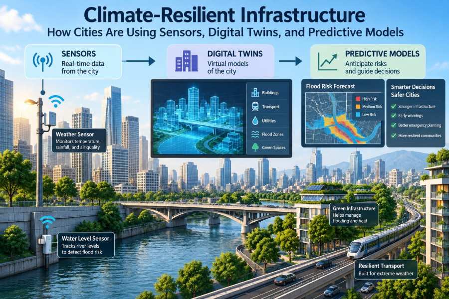
That is where sensors, digital twins, and predictive models can help. Used thoughtfully, these tools turn scattered observations into decisions about maintenance, emergency response, design, and long-term investment.
🌍 Why Climate Resilience Has Become an Infrastructure Question
Climate resilience is the capacity of a system to anticipate, withstand, respond to, and recover from disruptive conditions. For infrastructure, this includes keeping essential services functioning during heat, heavy rainfall, drought, coastal flooding, wildfire smoke, and other hazards.
The issue is not only whether a structure remains standing. A road can be structurally intact but unusable because floodwater blocks it. A power network can remain energized while overheated equipment reduces reliability. Resilience therefore concerns service, access, safety, and recovery time.
🏙️ Why Cities Face Compounding Risks
Urban areas concentrate people, assets, and interconnected networks. Impervious surfaces such as roofs, parking lots, and pavements speed runoff into drainage systems, while dense development can amplify heat through the urban heat island effect.
Risks also cascade. Flooded electrical equipment may disrupt pumping stations; a failed pump can worsen flooding; closed streets can delay emergency crews. Planning each asset in isolation misses these dependencies.
🧭 From Historical Design Values to Forward-Looking Decisions
Traditional engineering design commonly relies on historical records: rainfall intensity, river flows, wind speeds, and temperature ranges. Those records remain valuable, but they may no longer describe the full range or timing of future conditions.
A forward-looking approach does not require pretending that future climate is known exactly. It means testing assets against a credible range of scenarios, identifying where performance is most sensitive, and choosing measures that remain useful under uncertainty.
📡 What Infrastructure Sensors Actually Do
Sensors are devices that measure a physical condition and transmit, store, or display the result. They can track water depth, pipe pressure, pavement temperature, bridge movement, soil moisture, air temperature, vibration, or electrical load.
They do not make infrastructure resilient by themselves. Their value comes from placing the right measurement at the right location, checking its quality, and connecting it to a decision that someone can act on.
🌧️ Monitoring Rainfall, Water Levels, and Drainage
Rain gauges, radar feeds, water-level sensors, and flow meters give cities a much more detailed view of storm behavior than occasional field observations. A sensor in a flood-prone underpass can trigger an alert before drivers encounter dangerous water.
In drainage networks, water-level data can reveal where capacity is being lost. Repeatedly high levels upstream of one manhole may point to a blockage, undersized pipe, tide-related backflow, or an operational issue that deserves inspection.
🌡️ Measuring Urban Heat Where People Experience It
Regional weather stations are essential, but they may not show how strongly temperatures vary between a shaded park, a wide asphalt corridor, and a dense residential block. Local air and surface-temperature sensors can reveal these microclimates.
That information supports practical actions: prioritizing trees near transit stops, selecting cooler pavement treatments where appropriate, adjusting construction work schedules, or identifying facilities that need reliable cooling during heat events.
🌉 Watching Structures for Signs of Stress
Structural health monitoring uses instruments such as strain gauges, accelerometers, displacement sensors, and corrosion-related probes to observe how an asset behaves. Bridges, retaining walls, tunnels, dams, and coastal structures may all be candidates.
A change in a measurement is not automatically a failure. Temperature, traffic loading, and seasonal movement affect readings. Engineers interpret trends alongside inspections, design information, and knowledge of normal operating behavior.
🚰 Detecting Water-System Problems Earlier
Pressure and flow sensors can help utilities identify abnormal operating conditions in water networks. A sudden pressure drop may indicate a main break, while an unusual overnight flow pattern may warrant investigation for leakage or unauthorized demand.
During drought, sensors can also support demand management and reservoir operations. The goal is not surveillance for its own sake; it is conserving water, reducing losses, and maintaining equitable service under constrained supply.
🔋 Tracking Energy and Critical Equipment
Pump stations, substations, traffic signals, and treatment plants rely on equipment that can be vulnerable to heat, water intrusion, or power interruption. Monitoring temperature, vibration, current, and backup-power status helps operators distinguish normal variation from conditions that require intervention.
For critical facilities, the most useful data may be simple: Is the generator ready? Is the fuel level adequate? Is water entering an electrical room? Clear alarms can be more valuable than a complicated dashboard nobody watches.
🗺️ Why Location Gives Sensor Data Meaning
A water-level reading without a reliable location, elevation reference, timestamp, and unit is difficult to use. Geospatial context turns a number into an operational picture: which road is affected, which neighborhoods are upstream, and which assets are nearby.
Geographic information systems can combine sensor feeds with terrain, land use, pipe maps, building footprints, evacuation routes, and social vulnerability indicators. This helps teams understand both the hazard and who may be exposed.
🧹 Data Quality Is an Engineering Requirement
Field data is messy. Sensors can drift, lose communication, become blocked by debris, report in inconsistent units, or fail during the very event they are intended to monitor. A resilient monitoring program plans for those realities.
- Calibrate instruments and document maintenance.
- Flag implausible readings and missing data.
- Record metadata, including location, unit, sampling interval, and sensor type.
- Maintain backup methods for high-consequence measurements.
Data governance may sound administrative, but unreliable inputs can produce unreliable operational decisions.
🪞 Understanding the Digital Twin
A digital twin is a digital representation of a physical asset, system, or place that is connected, to varying degrees, with real-world data. It may range from a well-maintained asset model to a live operational model that updates as conditions change.
The phrase is sometimes used too broadly. A three-dimensional model alone is not necessarily a digital twin. The defining value is the connection between the physical system, its data, and a model that supports decisions.
🧩 The Building Blocks of a Useful Twin
A useful twin brings together several layers rather than relying on a visually impressive model alone.
| Layer | Purpose | Example |
|---|---|---|
| Asset information | Describes what exists | Pipe diameter, bridge material, installation year |
| Spatial context | Shows where assets interact | Elevation, parcels, roads, floodplain |
| Operational data | Shows current or recent conditions | Flow, pressure, pump status, temperature |
| Analytical model | Tests behavior and alternatives | Hydraulic, traffic, structural, or heat model |
| Decision workflow | Connects insights to action | Work order, alert, capital-project priority |
Not every project needs every layer at full detail. The right scope depends on the decision at stake.
🌊 A Stormwater Twin in Practice
A stormwater twin may combine topography, drainage-asset records, rainfall observations, water-level sensors, and a hydraulic model. During a storm, it can help operators estimate where water is accumulating and whether pumps, gates, or road closures should be considered.
Before a project is built, the same model can compare alternatives. For example, engineers can test whether enlarging a pipe, adding storage, restoring a channel, or distributing green infrastructure best reduces risk in a particular catchment.
🚇 Modeling Interdependent Urban Systems
The greatest resilience questions often sit between agencies and asset classes. A rail station may depend on street drainage, electrical supply, communications, nearby retaining walls, and accessible approaches for passengers.
Digital-twin programs can expose these relationships, but integration should be purposeful. Connecting every available dataset may create noise, security risk, and maintenance burden without improving any actual decision.
🔮 What Predictive Models Are Designed to Estimate
Predictive models use historical observations, physical laws, statistical relationships, or machine-learning methods to estimate a future condition. They may forecast stream levels, predict equipment failure risk, estimate pavement deterioration, or identify blocks likely to experience extreme heat.
Prediction is not certainty. A model provides an estimate with assumptions and limitations. Engineers should ask what output is being predicted, over what time horizon, and how errors would affect the chosen action.
⚙️ Physics-Based, Statistical, and Machine-Learning Models
Different model families answer different questions. Physics-based models represent processes such as flow, heat transfer, or structural response. They can be especially valuable when engineers need to understand mechanisms and test changes to a physical system.
Statistical and machine-learning models learn patterns from data. They may be useful for anomaly detection or short-term prediction when substantial relevant data exists. However, they can perform poorly when conditions shift beyond the patterns represented in their training data.
🧪 Calibration, Validation, and Uncertainty
Calibration adjusts model parameters so simulated behavior reasonably matches observed conditions. Validation checks the model against different observations that were not used for that adjustment. Both are essential before a model informs high-consequence decisions.
Uncertainty should be communicated openly. Rainfall forecasts, asset-condition records, soil properties, future development, and climate projections all contain uncertainty. Showing a range of plausible outcomes is often more honest and useful than presenting a single precise-looking result.
🎯 Turning Forecasts into Decision Thresholds
A prediction becomes operationally useful when it is tied to a pre-agreed action. If a model forecasts possible overtopping at a critical location, teams need to know who receives the alert, what confirms it, and what response follows.
Good thresholds balance missed events against false alarms. Setting an alarm too low can overwhelm staff and erode trust; setting it too high can leave too little time to act. Thresholds should be reviewed after real events and drills.
🛣️ Prioritizing Maintenance Before Failure
Condition monitoring and predictive models can support risk-based maintenance. Rather than servicing every asset on a fixed schedule or waiting for breakdowns, agencies prioritize work using likelihood of failure, consequence of failure, and practical access constraints.
For instance, a pipe with moderate deterioration under a hospital access road may deserve earlier attention than a similarly deteriorated pipe in a low-consequence location. This is not a shortcut around inspection; it is a way to focus inspection and maintenance resources.
🌿 Comparing Grey and Green Resilience Options
Traditional or “grey” infrastructure includes pipes, levees, pumps, seawalls, culverts, and detention structures. Green and nature-based measures include wetlands, tree canopy, bioswales, permeable surfaces, and restored floodplains.
Digital tools can compare how options perform under different events, but they should not assume one category always wins. A dense corridor may need a larger culvert, while a wider neighborhood strategy may benefit from distributed storage and vegetation. Hybrid solutions are common.
👥 Designing for People, Not Just Assets
Two neighborhoods can experience the same rainfall depth yet face very different consequences. Access to transportation, housing condition, language needs, age, disability, insurance, and nearby services influence the ability to prepare for and recover from disruption.
Resilience planning should include community knowledge. Residents often know where water first crosses a sidewalk, which underpass floods rapidly, or when a cooling center is hard to reach. Their observations can improve models and reveal priorities invisible in asset databases.
🔒 Cybersecurity and Privacy Cannot Be Add-Ons
Connecting operational technology creates potential entry points for cyberattacks. A compromised sensor feed, control system, or dashboard can create confusion during an emergency or interfere with service delivery.
Programs need role-based access, network segmentation where appropriate, software updates, backup procedures, and incident response planning. Cities should also minimize collection of personally identifiable data and explain clearly how any public-facing data will be used.
💰 Choosing the Right Scale of Investment
Advanced platforms can be expensive to procure, integrate, and maintain. Costs include field installation, communications, data storage, cybersecurity, licenses, staff training, model updates, and replacement of aging sensors.
A smaller, targeted system can be the better investment when it answers a specific operational question. Starting with a recurrent flood crossing, a critical pump station, or a heat-vulnerable transit corridor creates an opportunity to demonstrate value before expanding.
🧑🔧 The People and Processes Behind the Technology
Resilience technology changes work practices as much as it changes information. Operators, inspectors, planners, modelers, IT staff, emergency managers, and community-facing teams need shared procedures and a common understanding of the data.
Training should cover more than clicking through software. Staff need to know when a reading may be unreliable, when field verification is required, and who has authority to make time-sensitive decisions.
⚠️ Common Implementation Mistakes
Many promising projects underperform for predictable reasons. The problem is usually not that the technology was incapable; it is that the system was not designed around a clear decision and sustained operating process.
- Buying a platform before defining the use case and success measure.
- Installing sensors without assigning maintenance responsibility.
- Treating model outputs as facts rather than estimates.
- Ignoring legacy asset records and inconsistent identifiers.
- Building dashboards that display information but do not trigger action.
- Excluding frontline staff and affected communities from design.
A modest system with clear ownership generally outperforms an elaborate one that no team can maintain.
🧱 Building a Practical Implementation Roadmap
Start with a decision that matters: whether to close a flood-prone road, dispatch a crew, schedule pipe inspection, or prioritize capital renewal. Define the users, the required lead time, and the consequence of getting the decision wrong.
- Map the physical system, existing data, and known blind spots.
- Select measurements and models proportionate to the decision.
- Set data standards, ownership, maintenance plans, and security controls.
- Pilot in a bounded area and compare results with field observations.
- Document response procedures and train the people who will use them.
- Review performance after events, then improve or scale carefully.
📏 Measuring Whether Resilience Is Improving
Success should not be judged by the number of sensors deployed or the sophistication of a digital twin. Better indicators relate to outcomes: reduced service interruption, quicker detection, fewer repeat failures, safer access, clearer emergency decisions, or better targeting of maintenance funds.
Some benefits take years to observe, while near-term indicators can still be useful. Examples include data availability during storms, time from alert to inspection, model error after calibration, and the percentage of critical assets with current condition information.
🏛️ Procurement and Long-Term Ownership
Infrastructure systems may outlast the software and vendors selected today. Procurement should therefore address data ownership, export formats, documentation, interface requirements, support expectations, and the ability to update models over time.
Open standards and interoperable data practices can reduce dependence on a single supplier, though they do not eliminate the need for skilled internal ownership. Agencies should plan for the full lifecycle, not only the launch.
🎓 What Civil Engineering Students Should Learn From This Shift
Future civil engineers will still need strong foundations in hydraulics, geotechnics, transportation, structures, construction, and materials. Digital capability supplements these fundamentals; it does not replace them.
Useful additional skills include GIS, data literacy, coding or automation at an appropriate level, uncertainty communication, systems thinking, and collaboration across disciplines. Most importantly, engineers must be able to ask whether a digital result makes physical sense.
🧠 The Core Principle: Better Decisions, Not More Technology
Sensors provide observations. Digital twins organize and simulate systems. Predictive models estimate what may happen next. None is a substitute for sound engineering judgment, field inspection, public accountability, or investment in physical infrastructure.
The strongest programs begin with real service needs and use technology to make decisions more timely, transparent, and defensible. They acknowledge uncertainty, protect data, include affected communities, and keep a human being responsible for critical choices.
Climate-resilient infrastructure is built when cities combine trustworthy information, realistic models, and practical action to protect essential services under changing conditions. The technology matters most when it helps people act before disruption becomes disaster. 🌆📡🌿