
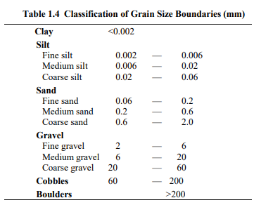
All languages describe “clay”, “sand”, “gravel”, etc., which are terms primarily based on grain size. In the very beginning of the 20th century, Atterberg, a Swedish scientist and agriculturalist, proposed a classification system based on specific grain sizes. With minor modifications, the Atterberg system is still used and are the basis of the International Geotechnical Standard, as listed in Table 1.4.
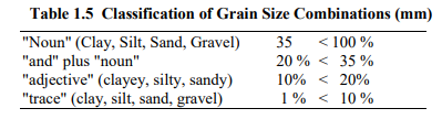
Soil is made up of grains with a wide range of sizes and is named according to the portion of the specific grain sizes. Several classification systems are in use, e.g., ASTM, AASHTO, and International Geotechnical Society. Table 1.5 indicates the latter, which is also the Canadian standard (CFEM 1992).
The International (and Canadian) naming convention differs in some aspects from the AASHTO and ASTM systems which are dominant in US practice. For example, the boundary between silt and sand in the international standard is at 0.060 mm, whereas the AASHTO and ASTM standards place that boundary at Sieve #200 which has an opening of 0.075 mm. Table 1.5 follows the International standard. For details and examples of classification systems, see Holtz and Kovacs (1981) and Holtz et al. (2011).
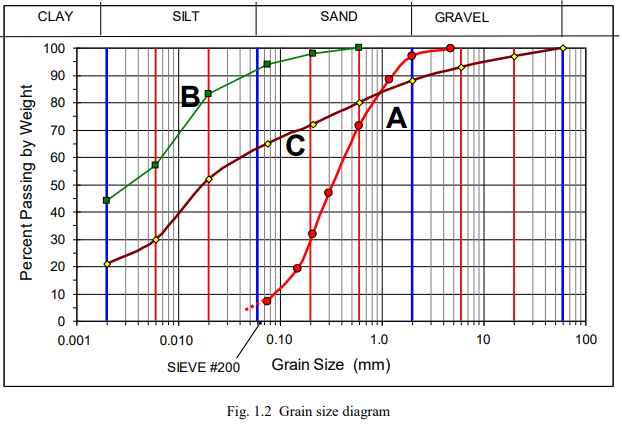
The grain size distribution for a soil is determined using a standard set of sieves. Conventionally, the results of the sieve analysis are plotted in diagram drawn with the abscissa in logarithmic scale as shown in Fig. 1.2. The three grain size curves, A, B, and C, shown are classified according to Table 1.5 as A: “Sand trace gravel trace silt”. B: Sandy clay some silt, and C: would be named clayey sandy silt some gravel. Samples A and B are alluvial soils and are suitably named. However, Sample C, having 21 %, 44 %, 23 %, and 12 % of clay, silt, sand, and gravel size grains, is from a glacial till, for which soil, all grain size portions are conventionally named as adjective to the noun “till”, i.e., Sample C is a “clayey sandy silty glacial till”.
The grain-size fractions are fundamental parameters for a foundation design. The above classification follows the Canadian standard (and the international). Several other systems are in use. In the US, the Unified Soil Classification System (USCS) is the dominant (e.g., Holtz and Kovacs 1981 and Holtz et al. 2011). Therefore, in addition to the soil description, every borehole log in a geotechnical engineering report should include the numerical results of grain size analyses to allow the users to apply their preferred system.
Note that soils are also classified by grain angularity, constituent minerals, organic content, etc.
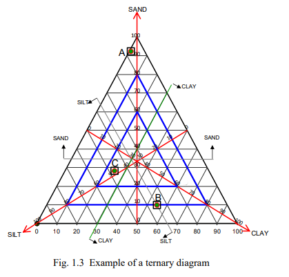
Sometimes, grain-size analysis results are plotted in a three-axes diagram called “ternary diagram” as illustrated in Fig. 1.3, which allows for a description according to grain size portions Clay+Silt+Sand to be obtained at a glance.

Comments are closed