
A heavy afternoon storm can turn an ordinary commute into a slow-moving queue of cars, buses, and pedestrians searching for a dry path. Water pools at kerbs, pours down stairwells, and sometimes enters shops or homes that have never flooded before.
It is tempting to blame these scenes on unusually intense rain alone. Yet flooding is often the visible result of a longer chain of decisions: where buildings were placed, how streets were graded, whether drains were maintained, and where runoff was expected to go.
For civil engineers, urban flooding is not just a drainage problem. It is a land-use, transport, public-health, environmental, and infrastructure-resilience problem that must be addressed across an entire catchment.
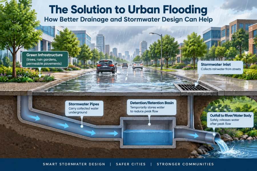
Better stormwater design cannot stop rainfall, but it can slow water down, give it safe places to go, reduce damage, and help cities recover faster. The most effective approach combines reliable underground drainage with visible, landscape-based systems that work with water rather than simply trying to hide it.
🌧️ What Urban Flooding Really Means
Urban flooding occurs when rainfall, rising water, or overloaded drainage systems cause water to collect where it disrupts daily life. This may include flooded roads, basements, rail corridors, underpasses, parks, and ground-floor properties.
It is different from river flooding, although the two can happen together. A city can flood during a short, intense storm even when it is far from a river, simply because water cannot enter or move through the drainage network quickly enough.
Pluvial flooding is flooding caused directly by rainfall overwhelming local surfaces and drainage. Understanding this distinction matters because the solution may begin at the street, plot, or neighborhood scale rather than at a distant river channel.
🏙️ Why Development Changes the Water Cycle
Before development, much rainfall is intercepted by vegetation, infiltrates into soil, evaporates, or moves slowly across the ground. Urban development replaces many of these pathways with roofs, roads, car parks, and paved walkways.
These hard surfaces are called impervious surfaces because little or no water passes through them. They convert rainfall into surface runoff quickly, producing larger flows over a shorter period.
A useful analogy is a sponge compared with a tray. Natural soil and vegetation act somewhat like a sponge, holding and releasing water gradually. A paved district acts more like a tray, sending water rapidly toward the lowest point.
💧 Runoff Volume Is Only Part of the Problem
Engineers consider not only how much runoff is produced, but also how rapidly it reaches the drainage system. A sudden peak flow can exceed the capacity of pipes and inlets even if the total storm volume is not extraordinary.
Dense development often shortens the route between roof, pavement, gutter, and drain. Steep roads, smooth surfaces, and connected hardstanding can concentrate runoff into fast-moving streams.
This is why a modest low point at an intersection can become hazardous. Water arriving from several blocks may converge there at the same time, while the local inlet can accept only a limited flow.
⏱️ The Importance of Peak Flow Timing
Stormwater systems are stressed most when runoff from different areas arrives simultaneously. If roofs, streets, and parking areas all discharge immediately into one pipe, the resulting peak may be much greater than the system can convey.
Detention systems reduce this problem by holding water temporarily and releasing it more slowly. Their purpose is not necessarily to eliminate runoff, but to change its timing.
This distinction is central to good design: managing a storm is often about flattening the peak, not merely moving water away faster. Sending runoff downstream too quickly can simply transfer the problem to another neighborhood.
🕳️ How Conventional Drainage Networks Work
Traditional urban drainage usually includes gullies or curb inlets, catch basins, pipes, manholes, culverts, channels, and outfalls. Water enters at the surface, travels through the network, and is discharged to a watercourse, coastal outlet, storage facility, or treatment system.
These systems remain essential. Streets, dense centers, tunnels, and building foundations need dependable drainage for frequent rainfall, and underground pipes protect public space from routine runoff.
However, a pipe network has a finite design capacity. It is not economically or physically realistic to size every pipe for every conceivable storm, especially where space is limited or downstream outlets are constrained.
🚧 Why Drains Overflow During Intense Storms
Drainage failures are often described as blocked drains, but blockage is only one cause. Water may overflow because inlets are submerged, pipes are undersized, outlets are backed up, pumps lose power, or the receiving river or tide level prevents discharge.
Once a pipe flows full, additional water cannot enter easily. It remains on the surface, follows road gradients, and may seek unexpected routes through driveways, building entrances, service corridors, or underpasses.
Surface flooding can therefore occur even where pipes are structurally sound. The question is not simply whether a drain exists, but whether the whole system can safely handle the combination of rainfall, runoff pathways, and downstream conditions.
🧭 Mapping the Whole Catchment
A drainage catchment is the area from which water drains to a particular point. Urban catchments do not always follow obvious natural boundaries because roads, walls, pipes, and land grading can redirect flow.
Effective planning begins by mapping topography, paved areas, pipes, manholes, inlets, waterways, outfalls, and known flood locations. Historical reports from residents and maintenance crews can reveal flow routes that are absent from older drawings.
Digital elevation models and hydraulic models can help engineers test how water may spread during different storms. Models are valuable decision tools, but they depend on assumptions and data quality, so field observations remain indispensable.
📏 Street Grading Is a Flood-Control Tool
The slope and crossfall of a street determine where water travels before it enters a drain. A poorly graded road may direct runoff toward a doorway, transit station, or low underpass instead of toward an inlet or safe overflow route.
Crossfall is the sideways slope that guides water from the road surface to the kerb. Longitudinal grade is the slope along the road. Both must be coordinated with kerb lines, driveway crossings, accessible routes, and drainage inlets.
Small level differences matter. A raised threshold, shallow channel, or carefully positioned kerb can keep shallow runoff away from vulnerable property without creating a hazard for pedestrians or vehicles.
🛣️ Designing Safe Overland Flow Paths
Every drainage network can be exceeded. For that reason, engineers should identify where water will travel on the surface during storms larger than the underground system can manage.
A safe overland flow path is a planned surface route that directs excess water toward a park, channel, road corridor, or other area where temporary ponding causes limited damage. It is the city’s backup route when buried infrastructure reaches capacity.
This does not mean deliberately flooding streets without care. It means avoiding designs that trap water behind walls, direct it into homes, or allow it to enter tunnels and critical facilities.
🌿 Green Infrastructure Explained
Green infrastructure uses soil, plants, and carefully shaped landscapes to manage stormwater close to where rain falls. It is also called blue-green infrastructure when water storage and conveyance are emphasized.
Common elements include rain gardens, bioswales, tree pits, green roofs, constructed wetlands, infiltration basins, and restored streams. These features can store water, encourage infiltration, filter sediment, and slow runoff.
They are not decorative add-ons. When properly designed, they form part of the drainage system, though they should be paired with overflow structures and maintenance plans rather than treated as a universal replacement for pipes.
🌱 Rain Gardens and Bioretention Areas
A rain garden is a shallow planted depression that receives runoff from a roof, path, or parking area. A more engineered version, often called bioretention, uses layered media, vegetation, drainage layers, and sometimes an underdrain.
Water ponds briefly at the surface, then filters through the soil mix or infiltrates into suitable native soil. The system can remove some sediment and pollutants while reducing the immediate runoff peak.
Plant selection should match the local climate and the expected cycle of wet and dry conditions. A rain garden that cannot drain or survive dry periods will not perform as intended.
🌳 Trees as Stormwater Infrastructure
Urban trees intercept rainfall on leaves and branches, while their root zones can improve soil structure over time. Large canopy trees can therefore contribute to runoff reduction as well as shade, cooling, and streetscape quality.
But planting a tree in a tiny compacted pit is not the same as providing functional stormwater storage. Tree trenches and expanded soil volumes can be designed to receive runoff while giving roots room to grow.
Designers must account for utilities, pavement loading, root management, and maintenance access. Trees are valuable allies, but they need adequate soil, water, and protection to deliver long-term benefits.
🧱 Permeable Pavement: Useful but Not Universal
Permeable pavement allows water to pass through joints or pores into an open-graded stone layer below. That layer stores water temporarily before it infiltrates, drains through an underdrain, or discharges slowly.
It can work well in low-speed parking areas, pedestrian zones, driveways, and lightly loaded streets. It is less suitable where sediment loads are high, groundwater conditions are unsuitable, or heavy traffic and poor maintenance may clog the surface.
Permeable pavement is not simply ordinary paving with gaps. Its subbase, edge restraint, drainage arrangement, and construction quality are fundamental to performance.
🏠 Managing Water at the Building Scale
Roof runoff is concentrated, predictable, and often easy to manage near the source. Downpipes can discharge to rain gardens, storage tanks, infiltration features, or controlled connections to the public drainage system where permitted.
Green roofs retain a portion of rainfall in their vegetation and growing medium, releasing water more gradually than a conventional roof. Their performance varies with roof build-up, plant cover, climate, season, and prior wetness.
Property-level measures cannot solve catchment-wide flooding by themselves. Still, widespread source control can reduce pressure on public infrastructure, especially when new development is required to limit its runoff impact.
🛢️ Detention and Retention Serve Different Purposes
Stormwater storage is often described broadly as a basin or tank, but its operating purpose matters. Detention stores water temporarily and releases it at a controlled rate. Retention keeps water for longer periods, allowing infiltration, evaporation, reuse, or permanent storage.
Below is a practical comparison.
| Approach | Primary function | Typical examples | Key design concern |
|---|---|---|---|
| Detention | Reduce peak discharge | Dry basin, underground tank, oversized pipe | Controlled outlet and safe overflow |
| Retention | Keep water on site or reuse it | Pond, wetland, rainwater tank | Water quality, safety, and long-term operation |
| Infiltration | Return water to the ground | Soakaway, infiltration basin | Soil permeability and groundwater protection |
The best choice depends on available land, soil conditions, groundwater level, downstream limits, water-quality needs, and the consequences if the facility overflows.
🧪 Infiltration Requires Ground Investigation
Infiltration can reduce runoff significantly, but it should never be assumed just because a site has open ground. Soil may be compacted, layered, contaminated, slow-draining, or close to groundwater.
Field testing and geotechnical investigation help determine whether infiltration is feasible and how a feature should be sized. Designers also need to consider setbacks from buildings, slopes, wells, utilities, and unstable ground.
In some locations, an underdrained bioretention system is safer than a fully infiltrating basin. The aim is to match the intervention to the site rather than forcing a fashionable solution onto unsuitable conditions.
🧹 Maintenance Is Part of the Design
A drainage asset that is difficult to inspect or maintain is likely to lose capacity over time. Leaves, litter, sediment, oils, and construction debris can block inlets and clog filter media, particularly at locations where runoff concentrates.
Maintenance should be planned before construction, with clear responsibility, access routes, inspection intervals, and a realistic budget. This applies equally to conventional pipes and green infrastructure.
- Inspect inlets before and during wet seasons.
- Remove sediment from catch basins, swales, and forebays when accumulation reduces function.
- Replace damaged plants and repair erosion in landscaped systems.
- Check control structures, pumps, gates, and overflow routes after major storms.
Maintenance records can also reveal recurring problems, such as a particular inlet that repeatedly silts up because road grading or upstream erosion has not been addressed.
🧼 Stormwater Quality Matters Too
Runoff can carry sediment, tire particles, metals, nutrients, oils, litter, and other contaminants from urban surfaces. When untreated runoff reaches streams or coastal waters, it can degrade aquatic habitats and water quality.
Slowing water often helps treatment. Sediment can settle in a forebay, vegetation can trap particles, and filter media can remove some pollutants before runoff leaves the site.
No single treatment feature removes every contaminant. Industrial areas, fuel-handling zones, and high-risk sites may need source controls and specialized treatment rather than relying only on planted drainage features.
🏗️ Construction Sites Need Temporary Drainage
During construction, exposed soil can be washed into drains and waterways far more easily than a completed landscaped site. Temporary erosion and sediment controls are therefore a core drainage responsibility, not an afterthought.
Measures may include stabilized entrances, covered stockpiles, silt fences where appropriate, sediment basins, temporary swales, and protected drain inlets. Their suitability depends on site slope, rainfall, soil type, and construction sequence.
Controls must be inspected and adjusted as work progresses. A measure that worked during excavation may become ineffective once earthworks, access roads, or drainage routes change.
🚇 Protecting Critical Infrastructure
Some locations deserve a higher level of flood protection because their failure disrupts far more than one property. Examples include hospitals, emergency routes, substations, rail corridors, water-treatment facilities, and communications infrastructure.
Protection can involve raised equipment, flood barriers, redundant pumps, backup power, protected entrances, and routes that keep emergency access open. It can also involve separating critical assets from known low points where feasible.
Engineers should distinguish between preventing every drop of water from reaching an asset and ensuring that the asset can continue operating or recover quickly after an extreme event.
⚖️ Equity and Uneven Flood Risk
Flood risk is not distributed evenly across a city. Lower-lying areas, neighborhoods with limited drainage investment, renters in ground-floor units, and people without vehicles or insurance may face greater difficulty responding and recovering.
Drainage projects should not merely protect highly visible commercial areas while redirecting excess water toward less powerful communities. Catchment-scale analysis must consider who benefits, who carries residual risk, and whether construction disruption is fairly managed.
Community knowledge is useful here. Residents often know which crossings become impassable, which drains overflow first, and which basements flood before official records capture the pattern.
🌡️ Designing for a Changing Climate
Rainfall patterns can change over the life of long-lived infrastructure, and past records may not fully represent future conditions. Higher temperatures can also affect soil moisture, vegetation health, and the intensity of short-duration storms in some regions.
Climate-resilient stormwater design uses scenarios rather than assuming one fixed future. It may include extra storage, adaptable outlet structures, protected overflow routes, space for future expansion, and careful protection of critical assets.
Uncertainty is not a reason to delay action. It is a reason to avoid brittle systems that work only within a narrow range of conditions.
🔄 The Value of Distributed Systems
A single large detention facility can be effective, but it may require substantial land and can become a single point of failure. Distributed measures spread storage and treatment across roofs, streets, parks, parking areas, and private plots.
For example, a neighborhood might combine tree trenches along roads, rain gardens in medians, green roofs on public buildings, permeable visitor parking, and a park designed for occasional temporary storage.
Distributed systems can provide multiple benefits, but coordination is essential. Without shared design criteria, maintenance responsibility, and an understanding of downstream connections, individual features may not add up to reliable catchment performance.
📐 Setting Clear Performance Targets
Projects need measurable objectives. These might address peak discharge, runoff volume, water quality, frequency of surface ponding, allowable flood depth on a route, or protection of a specific building threshold.
Targets should reflect the site’s consequences and connection to the wider system. A minor overflow in a landscaped park has a different consequence from water entering an underground station or emergency department.
Clear targets help engineers compare alternatives honestly. They also prevent vague claims that a feature is “sustainable” when its storage, drainage, overflow, and maintenance performance have not been defined.
🧮 Modelling Must Be Paired With Site Reality
Hydrologic models estimate how rainfall becomes runoff, while hydraulic models estimate how water moves through pipes, channels, and across surfaces. They are useful for testing design storms, identifying bottlenecks, and comparing interventions.
Yet models can miss blocked screens, undocumented connections, local depressions, changed land cover, or human behavior during a storm. Calibration against observed water levels and flood extents improves confidence where suitable records are available.
Site walks during or soon after rain are often revealing. They show ponding, bypassing, sediment paths, and inlet behavior in a way that plan drawings alone cannot.
⚠️ Common Drainage Design Mistakes
Several recurring mistakes increase flood vulnerability, even on projects with modern-looking drainage features.
- Ignoring the overflow route: storage systems need a safe path when their capacity is exceeded.
- Designing feature by feature: a rain garden, pipe, and road must work as one connected system.
- Forgetting maintenance access: inaccessible chambers and planted systems are difficult to keep functional.
- Assuming infiltration without testing: poor soils can leave water standing or create other risks.
- Discharging faster downstream: local relief can worsen flooding elsewhere in the catchment.
- Adding hardscape late in the project: extra paving can undermine calculations and storage allowances.
Most of these errors are coordination problems rather than failures of a single engineering calculation.
🤝 Collaboration Beyond the Drainage Team
Stormwater design intersects with architecture, landscape architecture, transportation, utilities, environmental management, planning, and asset operations. Decisions made by one discipline can change the hydraulic performance of another.
For instance, a landscape designer may need to preserve a shallow storage area, a road engineer may need to shape a kerb for controlled entry, and an architect may need to raise a vulnerable threshold. These are not separate details; they are parts of one flood-resilience strategy.
Early coordination is usually less costly than changing levels, pipe routes, or building entries after construction documents are nearly complete.
🏘️ Retrofitting Existing Neighborhoods
Older neighborhoods often have limited space, buried utilities, mature trees, and drainage networks built for past development patterns. Retrofitting requires creativity because there may be no vacant land for a large new basin.
Practical opportunities include rebuilding streets with bioretention curb extensions, converting selected parking spaces to planted storage, disconnecting roof downpipes where safe, upgrading critical inlets, and using parks for temporary storage during exceptional storms.
Incremental projects can be worthwhile when they follow a catchment plan. A sequence of small interventions should target the places where storage, conveyance, and risk reduction will be most useful.
🚨 Emergency Planning Complements Engineering
Even well-designed systems can be overtopped by severe events, equipment failures, or blockages. Emergency planning reduces harm when physical defenses are exceeded.
Useful measures include flood warnings where feasible, road-closure procedures, marked safe routes, pump and generator protocols, public guidance for property owners, and rapid inspection of known problem locations.
Emergency response is not a substitute for better drainage. It is the final layer in a broader strategy that includes prevention, mitigation, safe exceedance, and recovery.
✅ A Practical Framework for Better Stormwater Design
A robust approach moves from understanding the catchment to managing water at several scales. The following sequence is useful for both new development and retrofit planning.
- Map runoff sources, low points, assets, existing drainage, and observed flood paths.
- Reduce runoff at source through soils, vegetation, roof controls, and permeable surfaces where appropriate.
- Store and slow water through distributed detention, retention, or infiltration systems.
- Provide reliable conveyance for routine storms through inlets, pipes, channels, and controlled outlets.
- Plan safe surface overflow routes for larger events.
- Protect critical infrastructure and vulnerable buildings from residual risk.
- Assign maintenance duties, inspect performance, and adapt after real storms.
This layered method recognizes that no single pipe, pond, or rain garden can solve every flooding problem.
🌧️ The Core Principle: Make Space for Water
Urban flooding becomes more severe when cities treat water as something that must disappear immediately into a hidden pipe. A more resilient city accepts that heavy rainfall will sometimes occupy visible space and plans where, how deeply, and for how long that can happen safely.
Better drainage combines conventional engineering with landform, landscape, storage, maintenance, and thoughtful development control. It manages ordinary storms efficiently while providing safer outcomes when rainfall exceeds normal system capacity.
The goal is not to promise a flood-free city. The goal is to create a city in which water has managed pathways, vulnerable people and assets are protected, and disruption is reduced rather than amplified.
Urban flood resilience begins when every roof, street, park, pipe, and low point is designed as part of one connected water system. That mindset turns stormwater from an afterthought into a core element of safer, more livable urban infrastructure. 🌿🌧️🏙️