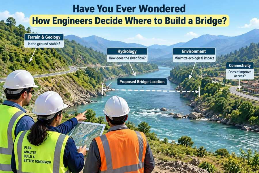

A bridge can look like a simple line from one bank to another: a road rises, crosses water or a valley, and returns to land. But the point where that line touches the ground may determine whether the project is economical, durable, safe, and useful for generations.
Imagine a busy town divided by a river. The narrowest crossing appears obvious on a map, so it may seem like the best place for a bridge. On site, however, engineers may find weak riverbed soils, a sharp bend that collects debris, protected habitat, or a connection that would force thousands of vehicles through residential streets.
Choosing a bridge location is therefore not a search for one perfect dot on a map. It is a structured process of balancing ground conditions, water behavior, transport needs, construction access, environmental effects, community needs, cost, and long-term maintenance.
That process begins well before anyone selects a bridge type or calculates the size of a beam. The first engineering question is often much more fundamental: should a bridge go here at all?
🗺️ A Bridge Site Is a Corridor, Not a Single Point
Early planning usually considers a crossing corridor: a broad zone where a bridge and its approach roads could reasonably be built. Within that corridor, engineers compare several possible alignments rather than immediately committing to one centerline.
This matters because the crossing itself is only part of the system. A location with a slightly longer span may produce straighter roads, fewer property impacts, safer junctions, and better access for emergency vehicles. Conversely, a short crossing can become expensive if its approaches require major retaining walls, deep cuts, or extensive land acquisition.
🎯 Start With the Purpose of the Crossing
Every site decision begins with the bridge’s job. A rural farm bridge, an urban pedestrian crossing, a railway viaduct, and a highway crossing over a tidal estuary face very different requirements.
Engineers ask practical questions: Who needs to cross? At what speed? What vehicles, loads, or users must be accommodated? Is the priority daily commuting, freight movement, evacuation resilience, network redundancy, or access to a growing district?
A bridge that serves the wrong travel pattern is not rescued by an elegant structural design. The location must support the intended movement from the beginning.
🚦 Travel Demand Shapes the Alignment
Transport planners examine existing routes, likely origins and destinations, and future land use. They do not simply ask where traffic is greatest today; they consider whether a new bridge will shift traffic onto unsuitable streets or unlock development that requires additional infrastructure.
For a pedestrian bridge, desire lines are especially revealing. People usually choose the shortest comfortable walking route, not the route an engineer wishes they would take. If ramps, stairs, or crossings make the bridge inconvenient, users may cross elsewhere at grade and create a safety problem.
For roads, the approach alignment should allow drivers to see clearly, slow or merge safely, and connect logically with the surrounding network.
📐 Geometry Cannot Be Added Later
A bridge needs approach geometry that meets the design requirements for its users. Road curves, grades, stopping sight distance, railway alignment, navigation clearance, and ramp gradients all influence where the structure can begin and end.
A bridge deck may need to sit high above a river to pass floodwater, driftwood, boats, or railway electrification equipment. Raising the deck also raises the approaches. In constrained urban areas, that can conflict with driveways, intersecting streets, buildings, and utilities.
This is why a promising river crossing can fail during early layout work. The bridge may fit, but the whole route may not.
🌍 Read the Land Before Designing the Structure
Topography—the shape of the ground—provides the first clues about viable sites. A steep gorge may offer strong rock close to the surface but demand tall piers and difficult access. A flat floodplain may permit simple approach roads but require a long structure across land that floods periodically.
Contour maps, aerial imagery, field walks, and digital terrain models help identify ridges, valleys, unstable slopes, drainage paths, and low points. These tools guide investigation; they do not replace it.
Engineers also look beyond the immediate banks. A bridge abutment placed near the top of a slope can still be affected by landslides, erosion, or groundwater movement farther uphill.
🧱 The Ground Must Carry the Load
Bridge loads travel from the deck through girders or arches, into piers and abutments, and finally into the ground. The ability of soil or rock to support those forces is often one of the strongest influences on site selection.
Good-looking ground at the surface can conceal soft clay, loose sand, compressible fill, cavities, or deeply weathered rock. Such conditions may require deep foundations, ground improvement, or a different alignment.
Geotechnical engineers investigate the subsurface using boreholes, test pits, sampling, and in-situ testing. Results help estimate bearing capacity, settlement, groundwater conditions, and the likely behavior of foundations under both normal and extreme loads.
🔍 Boreholes Turn Assumptions Into Evidence
A borehole is not merely a hole drilled in the ground. It is a sample point in a much larger geological story. Engineers use multiple investigation locations because ground conditions can change sharply across a river, valley, or former industrial site.
Samples may reveal layers of clay, sand, gravel, peat, rock, fill, or contamination. Testing can indicate strength, density, moisture sensitivity, and how readily water passes through the material.
Investigation always has uncertainty: it observes selected points, not every cubic meter of ground. A sensible site choice recognizes that uncertainty and reserves room in the design, cost estimate, and construction plan for risks that remain.
🏗️ Foundation Options Affect Location Choices
Shallow foundations can be economical where competent soil or rock is near the surface. Where weak layers extend deeper, engineers may consider piles, drilled shafts, caissons, or other deep foundation systems that transfer loads to stronger material.
Deep foundations can make challenging sites feasible, but they are not a free solution. They may require specialized equipment, underwater work, noise and vibration controls, complex quality verification, and higher cost.
A site is generally more attractive when its foundation solution is reliable and constructible, not simply theoretically possible.
🌊 Rivers Are Moving Systems
A river is not a fixed channel drawn in blue on a map. Its depth, flow speed, sediment, bank shape, and flood extent can change seasonally and over longer periods. A bridge location must work with that behavior rather than accidentally intensify it.
Hydraulic engineers study flow records where available, survey channel geometry, inspect floodplain features, and model how water may move through the crossing. They consider ordinary flows as well as rare but severe flood events used for design decisions.
The aim is not to prevent all flooding everywhere. It is to avoid creating unacceptable water levels, velocities, erosion, or damage risks upstream, downstream, and at the bridge itself.
🌀 Scour Can Undermine a Strong Bridge
Scour is the removal of soil or sediment by flowing water. Around a pier, water accelerates and swirls, potentially excavating a hole in the riverbed. At abutments, flow can erode banks and expose foundation elements.
A structure may have strong concrete and steel yet still be vulnerable if its foundations are not protected against scour. Engineers assess the likely depth and location of erosion, then select foundation depths, pier shapes, bank protection, or span arrangements accordingly.
Keeping piers out of the main channel can reduce hydraulic and maintenance challenges, although longer spans may increase structural cost. The preferred choice depends on the whole project, not one criterion alone.
🌧️ Floodplains Need Room to Work
Floodplains temporarily store and convey water during high flows. A road embankment and bridge opening can act like a partial dam if they restrict that passage too much.
Engineers evaluate whether water can pass beneath the bridge and through any relief openings needed across the floodplain. They also consider debris, sediment, and the possibility that floodwater approaches from directions that are not obvious during dry weather.
Building at the narrowest channel may sometimes constrict a wider floodplain. A longer crossing or a different corridor can reduce that effect and improve resilience.
⚓ Navigation and Clearance Set Vertical Limits
Where waterways are navigable, bridge location and height must accommodate the vessels expected to use the route. Requirements may include horizontal channel width, vertical clearance, pier protection, and visibility through the crossing.
Even on smaller waterways, kayaks, fishing boats, maintenance vessels, and emergency craft can affect the arrangement. Piers placed in a busy route can create collision hazards or force vessels into difficult currents.
A higher deck improves clearance but makes road approaches longer or steeper. This is a classic bridge-site trade-off: satisfying one physical constraint can create another.
🌬️ Wind, Ice, Waves, and Other Site Hazards
Not every bridge crosses a calm river. Coastal sites may experience tide, waves, salt spray, and storm surge. Mountain crossings can face strong winds, snow loading, avalanches, rockfall, or ice accumulation. Cold-region rivers may carry moving ice that loads piers and blocks openings.
These hazards influence both the preferred location and the structure’s detailing. A site sheltered from severe wave action may reduce exposure, while a location away from known rockfall paths can avoid costly protective works.
Hazard assessments are location-specific. Engineers use available records and observations, while acknowledging that extreme events cannot be predicted with absolute certainty.
🫨 Seismic Conditions Change the Conversation
In earthquake-prone regions, engineers consider local seismic hazard, soil conditions, slope stability, and the faulting potential of the corridor. Soft soils can amplify ground shaking, while loose saturated sand may be susceptible to liquefaction, where shaking causes a temporary loss of strength.
A bridge across an active fault zone may need special detailing or a different route entirely. The decision is not based solely on distance from a mapped fault; ground movement mechanisms and the consequences of disruption also matter.
Seismic design seeks controlled, ductile behavior and secure support conditions. Site selection can reduce the demands that the structure must resist.
🌱 Environmental Constraints Are Design Inputs
Wetlands, fish habitat, nesting areas, mature woodland, migration corridors, and sensitive aquatic ecosystems can all affect a bridge corridor. Environmental review is not an afterthought added after structural design; it helps narrow options early.
A longer span may avoid placing foundations in a sensitive channel. A different approach route may protect wetlands but require more earthwork elsewhere. Construction timing may also be limited to avoid sensitive breeding or migration periods.
Good projects try first to avoid impacts, then minimize unavoidable impacts, and finally address residual effects through appropriate measures required by the project’s approvals.
🐟 Construction Can Matter as Much as the Finished Bridge
A site that looks environmentally manageable in its final form may be difficult during construction. Temporary access roads, cofferdams, dewatering, pile driving, cranes, barges, and material storage can disturb land and water beyond the permanent footprint.
For example, a pier in a river may require isolating a work area from flowing water. That can be practical in a shallow, slow channel and far more disruptive in a deep or fast-moving one.
Engineers compare construction methods while comparing sites. A location that avoids complex temporary works often reduces both environmental risk and schedule uncertainty.
🏘️ Communities Live With the Approaches
Bridge projects change more than travel time. New approach roads can affect noise, air quality near traffic, privacy, views, business access, walking routes, and neighborhood character.
Public engagement helps planners identify local knowledge that maps may not show: school walking patterns, seasonal flooding, informal crossings, emergency access concerns, or streets already struggling with congestion. It also reveals where a technically possible route may face serious social disruption.
Listening does not mean every request can be met. It means decisions can be made with a fuller understanding of their consequences and explained more transparently.
🏛️ Land, Heritage, and Utilities Can Rule Out a Site
Property acquisition can be a major factor, particularly in dense areas. A bridge alignment may affect homes, businesses, farmland, rail property, or land with complex ownership arrangements.
Archaeological sites, historic landscapes, culturally significant places, and protected structures may require avoidance or careful investigation. Buried utilities—water mains, sewers, gas lines, electrical cables, and communications ducts—can also impose practical constraints.
Relocating a major utility is possible in some cases, but it can be costly, disruptive, and risky. Early utility mapping prevents unpleasant discoveries after an alignment appears to be settled.
🚧 Buildability Is a Core Engineering Test
A bridge must be buildable safely with available methods, equipment, labor, and access. Engineers ask how cranes will reach the site, where girders will be delivered, whether a work platform can be formed, and how workers will be protected around traffic or water.
Some bridges can be assembled span by span from the banks. Others may be launched, lifted, constructed by balanced cantilever, or built from barges. Each method has site requirements.
A location with limited access may still be selected, but its construction sequence needs to be credible. A design that cannot be safely constructed is not a viable design.
🚚 Access and Logistics Influence Cost
Large girders, concrete, reinforcement, piling rigs, and cranes must reach the work area. Narrow roads, low overhead lines, tight urban corners, weak temporary ground, or remote terrain can complicate deliveries.
Temporary works deserve careful attention. These are the supports, platforms, diversions, protective barriers, and access structures needed only during construction, yet they can control a project’s cost and safety risk.
In a hypothetical valley crossing, shifting the bridge several hundred meters to use an existing service road could reduce temporary access impacts even if the main span becomes slightly longer.
🛣️ Keeping People Moving During Construction
Many bridges replace an existing crossing or are built beside active roads and railways. The selected location affects whether traffic can remain open, whether detours are realistic, and how much work must occur during limited closures.
Railway work often faces particularly tight access windows because interruptions affect many services. Urban road projects may need to preserve pedestrian routes, bus operations, emergency response, and business deliveries.
Staging is not simply a contractor’s later problem. A site that permits safer, shorter, and less disruptive staging can be substantially more valuable than one with a marginally lower initial structural cost.
💰 Engineers Compare Life-Cycle Value, Not Just First Cost
Initial construction cost matters, but it is only one part of the decision. A location may need more excavation now yet avoid repeated flood repairs, difficult inspections, or traffic disruptions over decades of operation.
Life-cycle thinking considers expected costs and consequences throughout the bridge’s service life: inspection, painting or coating renewal, bearing replacement, deck repairs, scour monitoring, access equipment, and eventual rehabilitation.
The lowest bid for a crossing is not automatically the lowest-cost solution over time. At the same time, a more expensive option should show clear long-term benefits rather than relying on vague claims of quality.
🔧 Inspection Access Should Be Planned Early
Bridges require regular inspection. If piers stand in deep water, if bearings sit high above a road, or if deck edges are inaccessible, future inspection can require specialized equipment, lane closures, boats, or rope access.
Site selection and structural arrangement can make maintenance easier. Fewer piers in a channel may reduce underwater inspection needs; accessible abutments may simplify drainage repairs and bearing work.
Designing for inspection is a practical form of resilience. Problems are easier to manage when they can be seen and assessed before they become severe.
📊 Alternatives Need a Transparent Comparison
Because bridge location involves competing priorities, teams commonly use an alternatives comparison framework. It may combine engineering judgment with maps, cost estimates, environmental studies, traffic analysis, and risk registers.
| Criterion | Questions engineers compare | Possible site consequence |
|---|---|---|
| Ground | Is support reliable? How deep are competent layers? | Foundation type, settlement risk, cost |
| Water | How does the site behave in floods and scour? | Span arrangement, elevation, protection works |
| Transport | Do approaches connect safely and directly? | Travel benefit, junction changes, user safety |
| Environment | What habitats and waterways are affected? | Avoidance measures, permits, construction limits |
| Construction | Can access and staging be managed safely? | Schedule reliability, temporary works, disruption |
| Community | Who experiences property, noise, or access effects? | Acceptance, mitigation, route refinement |
A scoring table can organize discussion, but it should not disguise judgment as pure mathematics. The assumptions, weights, uncertainties, and reasons behind a preferred option should remain open to review.
⚖️ A Narrow Crossing Is Not Always the Best Crossing
One common misconception is that the narrowest river point always wins because it needs the shortest bridge. Narrow channels can have faster flow, deeper scour, steep banks, poor approach geometry, or a floodplain that extends far beyond the visible water.
Likewise, building where an old crossing already exists may appear convenient but can preserve outdated geometry, limit construction staging, or perpetuate a vulnerable flood location.
Length is an important variable, not a complete answer. Engineers seek the best overall corridor after testing the conditions that the map cannot show.
⚠️ Common Early-Stage Mistakes
Weak site selection often starts with a premature assumption: a preferred route is chosen before sufficient ground, hydraulic, or community information is available. Later discoveries then force costly redesign.
- Designing the bridge before studying the approaches: the deck fits, but safe roads or ramps do not.
- Relying on old mapping alone: channels, land use, utilities, and erosion conditions may have changed.
- Underestimating temporary works: a feasible permanent bridge may need impractical construction platforms.
- Treating environmental review as a final check: late constraints can eliminate an advanced option.
- Optimizing one criterion: minimizing span length can increase flood, access, or social impacts.
The remedy is not endless analysis. It is proportionate investigation at the right time, with decisions updated as evidence improves.
🧠 Digital Tools Help, but Field Work Still Matters
Geographic information systems, drone surveys, terrain models, traffic models, hydraulic simulations, and building information models allow teams to test alternatives quickly and communicate them clearly. They are especially useful for seeing how roads, flood levels, and land constraints interact.
But models depend on assumptions and input data. A drone image cannot directly reveal weak soil beneath a bank, and a traffic model cannot fully capture a resident’s daily walking route without good local information.
The strongest decisions combine digital analysis with site visits, targeted investigations, constructability reviews, and feedback from people who understand the area.
🤝 Bridge Location Is a Multidisciplinary Decision
No single engineer decides a bridge site alone. Civil, structural, geotechnical, hydraulic, environmental, transportation, survey, construction, and utility specialists each see different forms of risk.
Project teams also work with planners, landscape professionals, permitting authorities, owners, contractors, and affected communities. Their goals can conflict: a hydraulic engineer may favor fewer in-channel piers, while a structural engineer may see cost advantages in shorter spans.
The value of collaboration is not that it removes trade-offs. It makes trade-offs visible early enough to choose deliberately.
🧭 The Core Principle: Fit the Bridge to Its Place
A successful bridge site aligns physical conditions with human needs. It gives users a sensible route, provides foundations that can be built and monitored, respects water and terrain, limits avoidable environmental and community effects, and remains maintainable through its working life.
The final choice is rarely perfect. It is usually the option that manages the most significant risks responsibly while delivering the intended public or operational benefit.
For students, this is an essential lesson: bridge engineering starts before member sizing and load combinations. For working professionals, it is a reminder that early site decisions often create—or prevent—the hardest problems later in design and construction.
Engineers do not simply place a bridge across an obstacle; they choose a location where structure, landscape, water, transport, construction, and people can work together. That is why the best bridge site is discovered through evidence, comparison, and careful judgment rather than by looking for the shortest line on a map. 🌉🗺️🌊