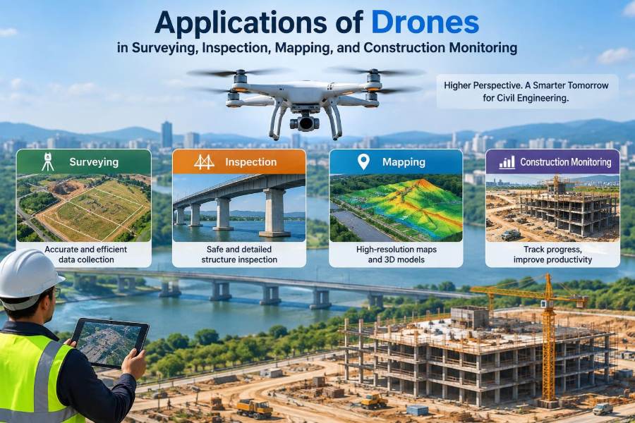

A survey crew arrives at a steep site after heavy rain. Parts of the ground are soft, access roads are blocked, and the client needs an updated terrain model before design decisions can continue. Walking every line may take days; sending people near unstable slopes creates avoidable exposure.
On another project, a bridge inspector needs clear views of bearings, joints, and the underside of a deck. A contractor also wants to know whether earthworks are following the planned levels. These are different tasks, but they share one practical need: reliable information from places that are difficult, slow, or unsafe to reach.
Drones, formally called unmanned aircraft systems or UAS, have become useful field tools for collecting that information. They do not replace engineering judgment, survey control, or close inspection. Used within a sound workflow, however, they can make site data more frequent, visual, and easier to compare over time.
The value is not simply that a drone can fly. The value comes from converting imagery and sensor readings into defensible measurements, maps, inspection records, and construction decisions.
🚁 What a Drone System Actually Includes
A drone operation is more than the aircraft. It includes the airframe, camera or sensor, batteries, controller, mission-planning software, processing software, trained operator, and a method for checking accuracy.
This distinction matters because a sharp image is not automatically a survey-grade result. The quality of the final product depends on the whole chain: flight design, camera calibration, positioning, ground control, processing settings, and review by competent staff.
🧭 Why Civil Engineering Uses Drones
Civil projects change quickly. A cut becomes a fill area, a stockpile changes shape, a scaffold blocks access, and a drainage route is altered. Conventional surveys remain essential, but repeating them everywhere at short intervals can be impractical.
A drone can capture a broad, current record of the site in one operation. That record supports measurement, planning, communication, and later verification when its limitations are understood.
📷 The Main Sensors Carried Aloft
Most engineering drone work begins with an RGB camera, which records ordinary colour imagery. Overlapping images can be processed through photogrammetry to build maps and three-dimensional models.
Other payloads serve more specialised purposes:
- LiDAR emits laser pulses and measures returns, helping create 3D point clouds and sometimes see through gaps in vegetation.
- Thermal cameras display surface temperature patterns, useful for targeted investigation.
- Multispectral sensors record selected wavelength bands, often used to assess vegetation condition or moisture-related patterns.
- Oblique cameras capture angled views of façades, bridge components, and excavations.
Sensor selection should follow the engineering question, not the novelty of the equipment.
🗺️ Photogrammetry and the Overlap Principle
Photogrammetry derives geometry from multiple images of the same feature taken from different positions. Software identifies matching visual points, estimates camera positions, and reconstructs a 3D scene.
For this to work well, images need sufficient forward and side overlap, stable focus and exposure, and a flight path suited to the terrain. A flat site may be captured with a simple grid. A tall retaining wall needs oblique imagery and several viewing angles.
📍 Coordinate Systems and Survey Control
Engineering data must sit in the correct coordinate reference system and vertical datum. A model that looks convincing but is shifted, rotated, or referenced to an unsuitable height datum can cause serious setting-out and volume errors.
Ground control points are marked locations measured independently with survey instruments. They anchor a drone model to known coordinates. Checkpoints, which are not used in processing, provide a more honest test of final accuracy.
🎯 RTK, PPK, and Their Limits
Real-time kinematic (RTK) positioning corrects satellite measurements during flight using a base station or correction service. Post-processed kinematic (PPK) positioning applies corrections after the flight. Both can improve camera-position estimates.
Neither method eliminates the need to plan verification. Satellite reception can be affected by obstructions, multipath reflections, correction interruptions, and unsuitable reference information. Control and independent checkpoints remain good practice where decisions depend on accuracy.
📐 Accuracy Is Not the Same as Resolution
Ground sample distance (GSD) describes the ground size represented by one image pixel. A smaller GSD can reveal finer detail, but it does not guarantee that coordinates are accurate to the same scale.
A useful distinction is simple: resolution tells you how much detail is visible; accuracy tells you how close a measured location is to its true position. Precision describes repeatability. Reports should state the checks used, rather than relying on appealing imagery alone.
🏞️ Topographic Survey and Existing Ground Models
Drones are effective for producing a broad representation of existing terrain on accessible, visible ground. A processed point cloud can support contours, spot levels, breakline interpretation, and a digital surface model.
A digital terrain model aims to represent bare earth, while a digital surface model includes visible objects such as vegetation, vehicles, and structures. Confusing the two can distort earthwork calculations and drainage assessment.
🌿 Vegetation and the Bare-Earth Challenge
Ordinary photographs record the top of grass, shrubs, and trees, not the soil beneath them. Software may classify some points as ground, but dense vegetation cannot be reliably wished away.
LiDAR can provide useful ground returns through openings in foliage, yet performance still depends on canopy density, pulse characteristics, terrain, and classification. Where critical levels are hidden, conventional ground observations are necessary.
🛣️ Route Corridors and Linear Infrastructure
Roads, railways, pipelines, canals, and transmission corridors are long rather than compact. Drone mapping can provide a consistent visual and geometric record along a selected alignment, especially during early route assessment or construction.
Corridor work needs careful planning for battery changes, changing terrain, public access, and data continuity. Long missions also increase the importance of airspace checks and a clear plan for lost-link or emergency events.
🏙️ Orthomosaics for Site Context
An orthomosaic is an aerial image corrected for camera perspective and terrain effects so that it can be viewed and measured like a map. It is particularly useful for site logistics, drainage paths, haul roads, material locations, and progress communication.
It should not be treated as a perfect substitute for a design drawing. Moving equipment, shadows, reflective surfaces, and poor image geometry can introduce seams or distortions that require review.
🧱 Point Clouds and Digital Twins
A point cloud is a dense collection of measured 3D points. It can represent a quarry face, structure, excavation, or completed work with far more spatial context than a small set of isolated survey points.
When linked to design information, asset records, or repeated observations, a model may contribute to a digital twin workflow. The term should be used carefully: a static 3D model is useful, but it becomes a true operational twin only when its data, updates, and purpose are managed.
📊 Earthwork Volumes and Stockpile Measurement
Drone-derived surfaces can estimate cut, fill, and stockpile volumes by comparing surfaces or calculating material above a defined base. This is valuable when piles are irregular or unsafe to climb.
The result is sensitive to the base surface, edge definition, occluded areas, material texture, and survey accuracy. Teams should agree on the measurement boundary and reference surface before comparing results. A volume difference can reflect changed method, not changed material.
🏗️ Progress Monitoring from Repeat Flights
Repeating a similar mission at planned intervals creates a visual time series of construction. It can show the advance of paving, structural erection, excavation, utility installation, or restoration.
Consistency matters. Comparable altitude, camera angle, overlap, coordinate system, and dates make change easier to interpret. A monthly image taken from the same location may communicate sequence better than many unstructured photographs.
🧩 Design-versus-As-Built Comparison
Processed drone data can be compared with a design surface or building model to highlight areas that appear high, low, incomplete, or outside a tolerance band. This is useful for screening earthworks and checking whether detailed field verification is needed.
It is not an automatic acceptance procedure. The relevant tolerances, datum, design revision, surface type, and uncertainty must be confirmed. Critical compliance decisions should follow the project’s approved quality-control process.
🌉 Bridge Inspection Without Routine Close Exposure
Drones can obtain close visual coverage of elevated piers, soffits, cables, deck edges, and difficult approach areas. High-resolution images let an inspector review potential cracking, corrosion staining, spalling, drainage defects, or missing components from a safer initial position.
Visual evidence remains subject to lighting, focus, viewing angle, and surface condition. A drone may identify where a hands-on inspection, access platform, or nondestructive test is required; it does not automatically establish defect depth or structural significance.
🏢 Buildings, Roofs, and Façades
For roofs and façades, oblique flights can document damaged cladding, ponding indicators, loose elements, blocked gutters, and locations that would otherwise require extensive access equipment for an initial review.
Urban work introduces hazards: people, traffic, glass reflections, wind turbulence around corners, and limited take-off areas. The most useful flight is often the conservative one, flown with clear exclusion zones and without pressing close to the building.
⚙️ Industrial Assets and Confined Locations
Plants, tanks, stacks, conveyors, and process structures benefit from rapid visual documentation, particularly during shutdown planning. Aerial views can help teams identify access routes and likely areas for detailed inspection.
Metal structures may interfere with navigation and satellite signals. Indoors or in enclosed spaces, satellite positioning may be unavailable altogether. Pilots need procedures suited to the environment, and the asset owner must control operational hazards.
🌡️ Thermal Surveys Need Careful Interpretation
Thermal imagery shows apparent surface temperature, not a direct diagnosis. A warm patch on a roof may relate to moisture, insulation discontinuity, solar loading, airflow, material emissivity, or the time of day.
Its strength is prioritisation. Thermal findings should be interpreted with knowledge of weather, building operation, surface finish, and inspection objectives, then confirmed through appropriate follow-up methods.
🚧 Safety Planning Before Take-off
A pre-flight assessment should consider aircraft condition, batteries, weather, obstacles, people, communications, emergency landing areas, and the task’s acceptable risk. It should also identify whether the mission is actually necessary that day.
- Define the survey or inspection objective and required accuracy.
- Establish take-off, landing, and exclusion areas.
- Brief the team on roles, aircraft movements, and stop-work authority.
- Set weather limits and battery reserves appropriate to the operation.
- Plan for degraded positioning, lost link, and unexpected people entering the area.
Rules vary by jurisdiction and operation. The operator must comply with applicable aviation requirements, site rules, permissions, and any conditions imposed by the project owner.
🌬️ Weather, Wind, and Light Conditions
Wind affects more than whether the aircraft can remain airborne. Gusts can reduce image overlap, blur photographs, alter planned geometry, and make close inspection near structures unsafe. Rain, fog, and dust may degrade sensors and visibility.
Light also changes data quality. Low sun can reveal surface texture but cast long shadows. Bright overcast conditions often help produce more even mapping imagery. The desired condition depends on whether the priority is visual defect detection or consistent surface reconstruction.
🔒 Privacy, Security, and Sensitive Data
Drone imagery can capture neighbouring property, people, vehicle registrations, security layouts, and commercially sensitive site conditions. Data governance should be part of project planning, not an afterthought.
Set clear rules for collection, retention, access, sharing, and deletion. Limit imagery to the task, protect storage, and communicate appropriately with affected site personnel and stakeholders.
💾 Data Processing and Quality Assurance
Processing should be reproducible. Record the flight, sensor, control coordinates, coordinate system, processing settings, exclusions, and quality checks. This creates a trail that another competent person can review.
Quality assurance includes looking for warped surfaces, poor alignment, gaps, blurred areas, control residuals, and checkpoint errors. Automated software warnings are useful, but they do not replace visual inspection of the model in the areas that matter.
🧾 Deliverables That Support Decisions
The best deliverable depends on the question. A superintendent may need a marked-up orthomosaic; a designer may need contours and breaklines; an inspector may need labelled close-up photographs; a quantity surveyor may need a documented volume basis.
| Need | Suitable output | Key caution |
|---|---|---|
| Site layout | Orthomosaic | Confirm scale and date |
| Terrain design | DTM, contours, points | Verify ground visibility and control |
| Asset review | Annotated images and 3D view | Do not infer hidden damage |
| Earthworks | Surface comparison and volume report | Define boundaries and base surface |
👷 Roles: Pilot, Surveyor, Engineer, Inspector
One person may hold several roles on a small project, but the responsibilities remain distinct. The remote pilot manages safe aircraft operation; the survey professional manages measurement integrity; the engineer interprets implications for design or construction; the inspector evaluates asset condition.
Clear responsibility prevents a common failure: assuming that the person who captured data has also validated every technical conclusion drawn from it.
⚠️ Common Mistakes That Reduce Value
Many problems are predictable. Flying too high may make defects invisible; flying too low may create unsafe proximity or poor geometry. Capturing imagery without control may produce a visually attractive but poorly located model.
- Using only software-reported accuracy rather than independent checkpoints.
- Measuring through vegetation, water, shadows, or occluded surfaces without qualification.
- Comparing data collected in different datums or design revisions.
- Delivering huge files without a clear question, map, or decision context.
- Overstating what visual or thermal data can prove.
🔧 Building a Practical Drone Workflow
Start with the decision that the data must support. Then define the accuracy, coverage, sensor, control, safe flight plan, processing method, checks, deliverables, and reviewer. This order prevents technology from driving the scope.
A useful pilot project is narrow and measurable: for example, document one stockpile area against an independently checked survey, or inspect a limited bridge elevation with agreed image labels. Lessons from that trial can shape procedures before wider deployment.
💰 Understanding Cost Beyond Flight Time
A short flight may create substantial work afterward: permissions, risk planning, control survey, processing, review, storage, annotation, and reporting. These activities are part of producing usable engineering evidence.
Conversely, the greatest saving may not be labour in the air. It may be avoiding unnecessary access equipment, reducing repeat visits, detecting a site issue earlier, or giving several teams a common current view of the work.
🤖 Automation and AI-Assisted Review
Software can assist with flight paths, object detection, crack screening, change highlighting, and image organisation. These tools can reduce the time needed to locate areas that deserve attention.
Automated classification is a screening aid, not a substitute for accountable interpretation. Training data, image quality, unusual materials, shadows, and site-specific conditions can all produce missed findings or false alerts.
🌍 Environmental and Community Considerations
Drones are often quieter and less intrusive than some access methods, but they still create noise, visual disturbance, and potential effects on wildlife or nearby communities. Sensitive locations may need timing restrictions and consultation.
Efficient planning also reduces repeat flights and unnecessary data capture. Good environmental practice is not separate from good engineering practice: both begin with a defined purpose and proportionate method.
📚 Skills Students and Professionals Should Develop
Useful drone capability combines field awareness with data literacy. Learn basic photogrammetry, coordinate systems, error sources, image interpretation, aviation safety principles, and the limits of each sensor.
Students can practise by comparing a small image-based model against known measurements and explaining discrepancies. Working professionals can strengthen capability by standardising checklists, metadata, review procedures, and handover requirements.
🔭 Where Drone Use Is Heading
Smaller sensors, improved positioning, better processing, and closer integration with geographic information systems and building models will continue to expand practical uses. Repeatable data collection may increasingly support condition histories rather than one-off reports.
The engineering fundamentals will not change. A more capable sensor still needs suitable control, a safe operation, a defined accuracy requirement, and a professional who understands whether the output is fit for its intended decision.
✅ The Core Principle: Useful Data, Not Just Impressive Images
Drones are most valuable when they are treated as one part of a measurement and inspection system. They can extend observation, improve access, create frequent records, and make complex sites easier to communicate.
They should be matched to the task rather than forced into it. Use conventional survey where hidden ground or high-precision setting out demands it; use close inspection and testing where visual evidence is insufficient; and use drone data where its coverage, safety, and repeatability genuinely improve the decision.
The successful drone programme is not defined by the aircraft in the sky, but by the reliability, traceability, and usefulness of the engineering decision it supports. With sound planning and honest limits, aerial data becomes a practical extension of civil engineering fieldwork. 🚁🗺️🏗️