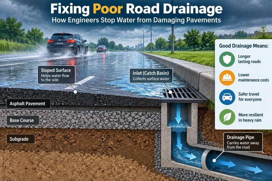

A familiar pattern appears after a hard rain: water gathers along the curb, a shallow pond forms near an intersection, and vehicles drive through it day after day. A few months later, the road surface begins to crack, rut, or break apart.
It is tempting to treat that damage as a paving problem alone. Often, however, the pavement is showing the consequences of a drainage problem that began at the surface, beneath the asphalt, or farther upstream in the surrounding catchment.
Roads must carry traffic, but they also have to shed water quickly and predictably. When they cannot, water weakens pavement layers, erodes supporting soil, creates safety hazards, and increases maintenance costs.
Good drainage is therefore not an accessory added after road design. It is one of the systems that allows a pavement to perform as intended over its service life.
🌧️ Why Water Is So Destructive to Pavements
Pavement materials are strongest when their supporting layers remain stable. Water changes that condition by entering cracks, joints, edges, and pores, then reducing the strength of the underlying base and subgrade.
The subgrade is the prepared natural soil or fill that supports the pavement structure. Above it are granular base layers and the asphalt or concrete surface. If any of these layers become saturated, loads from wheels are distributed less effectively.
Traffic then causes repeated deflection: the pavement bends slightly under each axle. With weak, wet support, those movements become larger and damage accumulates faster.
🛣️ The Road Is Part of a Drainage System
A roadway is not simply a flat strip of asphalt. Its crown, shoulders, curbs, gutters, inlets, pipes, ditches, embankments, and outlets work together to move runoff away from the structure.
Engineers usually consider two connected paths. Surface drainage carries rainfall over the pavement and into a collection system. Subsurface drainage controls water that infiltrates through the surface or rises from the soil below.
A road can fail even if one path works well. Fast surface runoff does not solve trapped groundwater, while a good underdrain cannot compensate for broad standing water caused by poor surface grading.
💧 What Happens When Water Enters the Layers
Water in an unbound granular base can reduce particle interlock and allow fine soil particles to move. In fine-grained subgrades, increased moisture can soften the soil and lower its ability to resist shear deformation.
Repeated loading may pump water and fines upward through cracks or joints. This process can leave voids, contaminate drainage layers, and create uneven support beneath the surface.
In cold climates, freeze-thaw action adds another mechanism. Water that freezes can expand and form ice lenses in frost-susceptible soil; later thawing can leave a saturated, weakened layer beneath the pavement.
📐 Start With Road Geometry
The simplest drainage tool is shape. Most two-lane roads are built with a central high point, or crown, so water flows toward both edges. One-way or multi-lane facilities may use a single crossfall toward one side.
Cross slope must be enough to move water, but not so steep that it compromises comfort, accessibility, vehicle control, or construction practicality. Required values depend on surface type, roadway function, climate, and local design criteria.
Longitudinal grade matters too. A curb-and-gutter street with very little slope along its length can retain water even if the crossfall is correct. The gutter needs a continuous route to an inlet or outlet.
📏 Crossfall, Grade, and the Problem of Flat Spots
A flat spot is a local low area that interrupts drainage. It may result from poor construction control, differential settlement, repeated resurfacing, or a utility trench that settled after backfilling.
These defects are easy to overlook on plans because drainage is governed by small elevation differences. In the field, a modest depression can create a pond that repeatedly wets a wheel path or pavement edge.
Survey checks, stringlines, straightedges, and digital surface models can all help identify suspect areas. After rain, visual inspection is equally valuable: persistent puddles reveal how the road actually behaves.
🚧 Curbs and Gutters: Useful but Not Self-Cleaning
Curbs direct runoff along the edge of an urban road and protect adjacent areas from uncontrolled sheet flow. Gutters provide the shallow channel that carries that water toward a catch basin or inlet.
But curbs also concentrate runoff. If inlet spacing is too wide, an inlet is blocked, or the gutter has insufficient grade, water can spread out across travel lanes and create nuisance ponding.
Designers must also consider debris. Leaves, sediment, litter, and gravel naturally collect at low points. A drainage layout that depends on every grate staying perfectly clean is not a resilient layout.
🕳️ Inlets Must Capture Water at the Right Place
Inlets collect gutter flow and transfer it to a storm drain. Their performance depends on grate type, inlet opening, gutter slope, approach flow, local geometry, and the depth and width of water approaching the inlet.
An inlet located after the low point may miss the main flow path. An inlet on the high side of a superelevated curve may be nearly useless, while water concentrates on the low side.
Engineers commonly provide additional capacity near sag points, intersections, pedestrian crossings, bridge approaches, and places where runoff from adjacent land enters the street. The objective is not merely to install inlets, but to limit spread and direct water safely.
🌊 Design for the Whole Catchment, Not Just the Pavement
The catchment, or drainage area, is all land that drains toward a road feature. On a rural road, this may include an uphill field or cut slope. In a city, roofs, parking lots, driveways, and side streets can greatly increase runoff reaching the gutter.
Development often replaces permeable ground with hard surfaces. More rainfall then becomes rapid runoff, and a roadside drain sized for earlier conditions may become inadequate.
A useful site review traces water beyond the roadway boundary. Where does it originate? Which way does it flow during a storm? Does an upstream culvert discharge directly onto a vulnerable shoulder?
🧮 Estimating Runoff Without False Precision
Drainage design uses local rainfall information, catchment characteristics, land cover, slope, and storage effects to estimate design flows. The selected rainfall event and calculation method are set by the project’s authority, road classification, and acceptable level of risk.
Early calculations are only as reliable as the inputs. A drainage area drawn incorrectly, an ignored driveway, or an assumed outlet condition can produce a misleadingly neat result.
For students, the central idea is more useful than memorizing a single formula: the system must safely convey the runoff expected at the critical location while accounting for how the site stores, concentrates, and releases water.
🧱 Keep Water Out of the Surface in the First Place
Asphalt is not perfectly watertight, especially as it ages. Cracks allow water downward, and poorly sealed joints or utility cuts can become direct infiltration paths.
Preventive maintenance slows this process. Crack sealing, joint sealing, surface treatments, and timely patching can reduce infiltration before deep structural damage develops.
These measures are not substitutes for drainage correction. Sealing a cracked pavement over saturated layers may delay visible distress, but it does not restore a failed outlet, blocked underdrain, or poor grade.
🪨 Drainage Layers Beneath the Pavement
Some pavement systems include a permeable drainage layer designed to move infiltrated water laterally toward an outlet. This layer usually uses clean, open-graded aggregate or another material with high hydraulic conductivity.
Its benefit is speed: water has less time to remain in a load-bearing layer. Its challenge is protection. Fine particles from the subgrade or adjacent layers can migrate into open voids and reduce drainage capacity.
Filter layers or geotextiles may be used to separate materials while allowing water to pass. Material selection must consider gradation, compatibility, constructability, and the risk of clogging over time.
🧵 Geotextiles and Filters Need Careful Design
A geotextile is a permeable synthetic fabric used for separation, filtration, reinforcement, or drainage. In road drainage, it often prevents fine soil from entering coarse aggregate while maintaining a flow path.
It is not automatically the right answer for every wet site. A fabric can clog if the soil-fabric-water system is poorly matched, and damage during construction can compromise its function.
The key question is functional: should the interface separate materials, filter water, reinforce weak ground, or drain water? Selecting a product without first defining that role is a common design mistake.
🔩 Underdrains Give Water an Exit Route
An underdrain is typically a perforated pipe surrounded by free-draining aggregate and connected to a suitable outlet. It intercepts groundwater or collects water from a pavement drainage layer.
Underdrains are particularly useful along low sides of cut sections, behind curbs where water may be trapped, near springs, and where seepage softens pavement support. They are also common at pavement edges in some designs.
A pipe without an outlet is storage, not drainage. Outlet location, protection from erosion, access for maintenance, and avoidance of backwater are as important as the perforated pipe itself.
🏞️ Ditches Work When Their Shape Is Stable
Rural roads often rely on roadside ditches rather than curbs and storm sewers. A ditch must convey runoff while resisting erosion and keeping water sufficiently below the pavement structure.
Steep slopes can produce erosive velocities, while nearly flat ditches may retain sediment and vegetation. Check dams, lining, grade control, or a redesigned alignment may be appropriate depending on flow, soil, and maintenance capacity.
Deepening a ditch is not always a cure. It can create safety concerns, destabilize slopes, interfere with access, or alter groundwater conditions. The ditch must be designed as part of the corridor rather than excavated as an afterthought.
🌉 Culverts Must Pass Flow and Protect the Embankment
Culverts carry water beneath roads, driveways, and embankments. If undersized, obstructed, or poorly aligned, they can cause upstream ponding, overtopping, erosion, or washout around the structure.
Inlet and outlet conditions strongly affect performance. Debris accumulation at an inlet may sharply reduce capacity, while high-velocity discharge at the outlet can erode soil and undermine the channel or road fill.
Headwalls, end treatments, riprap, energy dissipation, and appropriate channel transitions are selected to suit the site. They should be designed for hydraulic behavior, not added solely because they look standard on a detail sheet.
🧭 Outfalls Are Often the Weakest Link
Every collected flow needs a legal, stable, and functioning destination. A storm sewer may discharge to a ditch, watercourse, detention facility, or municipal network, but the receiving system can control the entire road drainage performance.
If the downstream channel is eroded, blocked, or already full during a storm, water may back up into pipes and inlets. An otherwise adequate roadside system can then pond at the road surface.
Design should examine the full path to the outfall and the condition of the receiving area. Local environmental, permitting, and flood-management requirements can substantially affect what outlet solutions are feasible.
🚜 Shoulders and Pavement Edges Need Protection
Pavement edges are structurally vulnerable because they receive less lateral support than the interior. Water entering from an unpaved shoulder can soften the edge support and contribute to cracking or breakup.
A well-graded shoulder directs water away rather than toward the pavement. Its material also needs enough stability to resist traffic encroachment, rutting, and erosion.
Edge drains, stabilized shoulders, and properly maintained side slopes are possible tools. The right solution depends on traffic, geometry, soil, available right-of-way, and whether the corridor is urban or rural.
🚛 Heavy Vehicles Reveal Drainage Failures Quickly
Water damage becomes most visible where wheel loads are high: bus stops, freight routes, climbing lanes, industrial entrances, intersections, and turning areas. Slow-moving heavy vehicles apply load for longer and can worsen deformation in a wet foundation.
For example, a hypothetical truck entrance may show deep depressions near a drain. Replacing only the surface asphalt could produce a short-lived repair if the base remains saturated or the inlet leaks into the trench.
Investigations should match the repair to the mechanism. Core samples, test pits, drainage observations, and condition mapping often reveal whether the issue is surface wear, loss of support, or both.
🧊 Cold Regions Add Freeze-Thaw Risks
In freezing environments, drainage must limit water available to freeze in susceptible soils. Frost heave can raise parts of the pavement unevenly; spring thaw can then create weak, saturated zones beneath a seemingly intact surface.
Insulation, frost-resistant material selection, improved drainage, greater separation from groundwater, and seasonal load management may all be considered. None is universally appropriate, because soil type and climate vary sharply by location.
Drainage outlets also need attention in winter. Ice, snow storage, and frozen inlet openings can block paths that work well during warm-weather storms.
🌱 Green Drainage Can Help, Within Limits
Vegetated swales, bioswales, infiltration strips, and detention features can slow runoff, promote infiltration where ground conditions allow, and improve water quality by trapping sediment.
They are especially useful where space is available and runoff can be managed before it reaches a piped system. However, they require suitable soils, safe overflow routes, vegetation maintenance, and careful treatment near weak pavement foundations.
Infiltration beside a road is not always desirable. On sensitive subgrades or in constrained urban corridors, directing more water into the ground may increase pavement moisture rather than solve the problem.
🔍 Diagnose Before Choosing a Repair
A drainage repair begins with evidence, not a preferred product. Observe the road during rainfall where safe, inspect it afterward, review plans and maintenance records, and identify where water enters and where it should leave.
Useful clues include recurring potholes at low points, wet shoulders in dry weather, sediment fans at outlets, water stains on curbs, pumping at cracks, and vegetation patterns along ditches.
- Map ponding, cracks, ruts, and edge failures.
- Check inlet grates, pipes, ditch continuity, culvert ends, and outfalls.
- Measure key elevations rather than relying only on visual judgment.
- Investigate pavement layers where structural weakening is suspected.
- Separate immediate safety actions from permanent rehabilitation work.
🛠️ Match the Fix to the Failure Mechanism
Standing water caused by a local depression may need milling and resurfacing to restore drainage geometry. A blocked inlet may need cleaning and a revised maintenance schedule. A saturated base may require excavation, drainage improvements, and reconstruction.
There is often more than one contributing cause. A sound repair sequence addresses the water source, the route, the outlet, and any damaged pavement materials.
| Observed condition | Likely drainage concern | Potential response |
|---|---|---|
| Ponding in wheel path | Local low spot or inadequate inlet capture | Survey grades; restore crossfall; improve collection |
| Repeated edge breakup | Wet shoulder or poor edge support | Regrade shoulder; improve edge drainage; rebuild weakened layers |
| Wet ditch and soft pavement nearby | Seepage or high groundwater | Assess underdrain and outlet options |
| Scour at culvert outlet | Excess discharge velocity or unstable receiving channel | Add suitable protection and revise outlet transition |
These are diagnostic starting points, not automatic prescriptions. Site investigation and applicable design requirements determine the final solution.
⚠️ Common Fixes That Fail Too Soon
Overlaying asphalt without correcting trapped water is a classic short-term response. The new surface may look excellent, yet cracking and deformation can return when the underlying layers remain wet.
Another mistake is adding an inlet without confirming pipe capacity and downstream conditions. Collection at the surface improves little if the pipe surcharges or the outfall is blocked.
Other avoidable failures include:
- placing permeable aggregate with no positive outlet;
- using filter material without checking soil compatibility;
- allowing construction sediment into newly installed drains;
- creating abrupt grades that trap water near driveways or crossings;
- assuming a ditch will remain functional without vegetation and sediment control.
👷 Construction Quality Determines Drainage Performance
Small construction deviations can defeat a sound drainage design. Incorrect pipe slope, crushed perforated pipe, separated joints, misplaced inlets, poorly compacted trench backfill, and damaged geotextile all create long-term vulnerabilities.
Inspection should verify line and grade, bedding, aggregate cleanliness, filter placement, pipe connections, outlet condition, and final surface elevations. Before backfilling, drainage features are far easier to inspect and correct.
Temporary construction drainage matters as well. Uncontrolled runoff can erode incomplete subgrades, fill pipes with sediment, and leave problems hidden beneath finished pavement.
🧹 Maintenance Is Part of the Design Life
Drainage systems change after construction. Sediment accumulates, vegetation grows, grates clog, pavements settle, and upstream development changes runoff patterns.
A practical maintenance program uses inspections before expected wet periods and after major storms, while giving special attention to known low points and debris-prone locations. The goal is to find loss of function before it becomes pavement damage.
Maintenance records are valuable engineering data. Repeated blockage at the same inlet may indicate a grading problem, inadequate sump capacity, nearby erosion, or an upstream source of sediment.
📋 A Practical Field Inspection Routine
For a quick condition review, begin upstream and walk or drive the drainage route toward the outlet. This prevents a local symptom from distracting attention from the source.
- Identify the drainage divide and likely runoff paths.
- Inspect pavement crossfall, gutter flow lines, shoulders, and low points.
- Check inlets, manholes, ditches, culverts, and visible pipe connections.
- Look for settlement, erosion, sediment, seepage, and pavement distress.
- Confirm that water has a continuous path to a stable outfall.
- Document locations with photos, elevations, and weather context where possible.
This routine does not replace a formal hydraulic or geotechnical assessment. It does, however, create a disciplined basis for deciding what needs deeper investigation.
🤝 Coordinate Drainage With Other Road Features
Drainage interacts with utilities, sidewalks, cycle lanes, driveways, retaining walls, landscaping, and accessibility features. A curb ramp, for instance, must be designed so it is usable while avoiding a puddle across the crossing path.
Utility trench restoration deserves particular care because it can form a longitudinal low line or a preferential route for water. Coordination among designers prevents one discipline from blocking another’s drainage path.
Road safety is also involved. Water spread can reduce tire grip, conceal potholes, splash pedestrians, and create icing hazards. Drainage decisions should therefore be reviewed alongside geometric and traffic-safety design.
📚 Know the Limits of Rules of Thumb
Rules of thumb can help identify obvious problems, but they are not substitutes for local criteria and site-specific analysis. Rainfall patterns, soil behavior, environmental constraints, pipe standards, maintenance resources, and road importance vary widely.
For major projects, engineers may need survey data, hydrologic and hydraulic modeling, geotechnical investigation, utility information, and environmental review. Existing roads can also contain undocumented pipes or altered drainage routes.
When failure affects public safety, flood risk, slope stability, or a critical route, the repair should be developed and reviewed by suitably qualified professionals under the applicable authority’s requirements.
✅ The Core Principle: Move Water Away, Keep Support Dry
Reliable road drainage follows a simple chain: shape the surface to shed water, collect concentrated flow, convey it through stable features, discharge it safely, and prevent water from lingering in pavement layers.
Each link matters. A well-sloped surface cannot overcome a blocked outlet, and a large culvert cannot protect a pavement whose base is continually saturated by edge infiltration.
The most durable solutions treat drainage as a system and investigate the full route of water—from rainfall and runoff source to the final outfall—before rebuilding the pavement above it.
A road lasts longer when engineers manage water deliberately at the surface, within the pavement, and beyond the road edge. That mindset turns recurring patches into durable, evidence-based repairs. 🌧️🛣️💧