
A bridge rehabilitation project may begin with a familiar problem: drawings from different years do not fully match the structure in the field. A contractor discovers an unexpected utility line, an inspector needs access above live traffic, and the owner wants to know whether a repair will disrupt service next month.
None of these problems is solved by a single piece of software or a drone flight. They are coordination and information problems. Modern infrastructure is built, maintained, and operated by many people over long periods, often while the public continues to use it.
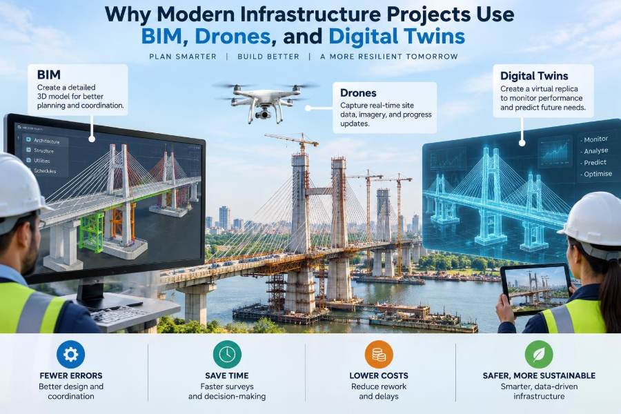
That is why digital tools have moved beyond presentation models and aerial photographs. Building Information Modeling (BIM), drones, and digital twins help project teams create a more reliable picture of what exists, what is planned, what is happening now, and what may need attention next.
Used carefully, these tools can reduce uncertainty rather than merely produce more data. Their value comes from connecting field conditions, engineering decisions, construction work, and asset management into workflows that people can actually use.
🏗️ Infrastructure Is an Information-Heavy System
A road, rail corridor, water treatment plant, tunnel, or flood barrier is more than concrete and steel. It also includes surveys, geotechnical records, permits, design calculations, utility information, construction schedules, inspection findings, and maintenance history.
These records are often created by different organizations in different formats. When information is disconnected, teams spend time searching for the latest version, checking dimensions manually, or resolving conflicts after work has already started.
Digital delivery aims to make trustworthy information available when a decision must be made. BIM, drones, and digital twins serve different roles in that larger objective.
🧩 What BIM Means in Civil Engineering
BIM is commonly described as a 3D model, but that is incomplete. In civil engineering, BIM is a structured process for creating and managing digital representations of physical assets and the information associated with them.
A bridge pier object, for example, may be linked to its geometry, material, design designation, reinforcement details, construction sequence, inspection requirements, and asset identifier. The model is useful because those relationships can be coordinated and checked.
BIM is not automatically accurate simply because it looks realistic. Its reliability depends on survey control, modeling rules, review procedures, and clear responsibility for each item of information.
📐 Beyond Geometry: Information Attached to Objects
Traditional drawings communicate design intent through lines, notes, and dimensions. BIM retains those outputs but can attach data directly to model elements. This helps users query the model instead of interpreting every detail visually.
For a drainage network, a team might identify pipe diameter, slope, material, invert levels, connection type, and installation status from structured model data. That makes coordination and quantity review more systematic.
Not every object needs every possible field. Excessive detail can make models difficult to maintain. The right level of information is determined by the decisions the project needs to support.
🗺️ Why Civil Projects Need a Spatial Context
Infrastructure is inseparable from location. A building model may focus mainly on a site, while a highway or pipeline can extend for many kilometres across changing terrain, property boundaries, waterways, and utility corridors.
For that reason, civil BIM often works alongside geographic information systems (GIS). GIS is especially useful for map-based analysis and wide-area asset information, while BIM provides detailed engineered geometry and component-level data.
A well-connected workflow lets a designer examine a culvert in its precise corridor context while an asset manager sees its condition and work history across an entire network.
🚁 What Drones Add to Project Work
Drones, also called unmanned aircraft systems, collect aerial images, video, and sensor data without requiring a person to enter every difficult location. On infrastructure sites, they are commonly used for surveying, progress records, inspection support, and site observation.
A drone does not replace engineering judgment or a qualified inspection. It provides a safer or faster way to obtain visual and measurement information in places that may be elevated, remote, hazardous, or disruptive to access.
Its usefulness depends on the sensor, flight planning, permissions, weather, lighting, ground control, and the accuracy required for the task.
📷 From Images to Measured Site Data
Many drone workflows use photogrammetry: software compares overlapping photographs to reconstruct a three-dimensional point cloud or surface. With suitable controls and validation, this can support orthomosaic maps, terrain models, stockpile estimates, and progress comparison.
Some drones carry lidar sensors, which emit laser pulses to measure distances. Lidar can be useful where vegetation or complex geometry limits image-based reconstruction, although it has its own processing and classification requirements.
Outputs must be checked against independent survey information when they will influence design, quantities, or acceptance decisions. A visually convincing model is not the same as a survey-grade dataset.
🎯 Survey Control Is the Foundation of Accuracy
Ground control points and check points tie drone-derived data to a known coordinate system. Control points help orient the model; independent check points help test whether the result meets the intended tolerance.
Errors can enter through poor point placement, incorrect coordinate transformations, unstable targets, inadequate image overlap, or weak satellite positioning. A small horizontal or vertical discrepancy can matter greatly near drainage grades, rail alignments, or clearance envelopes.
Accuracy is a project requirement, not a label attached to a technology. The data collection method should be selected after defining the decision it will support.
🪞 Digital Twins Are Living Asset Representations
A digital twin is a digital representation of a physical asset that is connected, to an appropriate extent, with current or periodically updated information. It may combine an engineering model with inspection records, operational data, sensor readings, maintenance events, and location data.
The word “twin” can be misleading if it suggests a perfect duplicate. Most infrastructure twins are selective representations designed for particular uses, such as monitoring a pump station, planning maintenance, or evaluating a bridge component’s condition.
A static 3D model becomes more twin-like when it is governed, updated, and connected to real asset information over time.
🔄 The Difference Between BIM and a Digital Twin
BIM is often strongest during planning, design, and construction, although its information can continue into operations. A digital twin usually emphasizes the operational life of an asset and its connection to changing conditions or live systems.
The boundary is not rigid. A construction model can feed an operations twin, and a twin may use BIM geometry as one of its visual and data foundations.
| Tool or approach | Primary question | Typical output |
|---|---|---|
| BIM | What is designed or built, and how do parts coordinate? | Coordinated model, drawings, quantities, asset data |
| Drones | What does the site or asset look like now? | Images, point clouds, maps, surface models |
| Digital twin | How is the asset performing and changing over time? | Connected asset view, condition and operational insight |
These approaches overlap, but treating them as identical can lead to unclear expectations and poorly defined deliverables.
🔗 Why the Three Technologies Work Well Together
A coordinated model can establish the intended geometry and asset structure. Drone surveys can provide evidence of actual site conditions and construction progress. A digital twin can carry selected verified information into operation.
Consider a hypothetical roadway interchange project. The BIM model coordinates bridges, drainage, retaining walls, and utilities; periodic drone data identifies earthwork progression and compares site surfaces with the planned corridor; handed-over asset records then support inspections and maintenance planning.
The integration is valuable only if common coordinates, naming rules, and update responsibilities are established from the start.
⚙️ Clash Detection Before Work Reaches the Field
Clash detection uses model-based rules to identify possible conflicts, such as a proposed pipe crossing a foundation, inadequate clearance around equipment, or competing utility routes. It is most effective when teams also review whether detected conflicts are meaningful.
Not every software “clash” is a construction problem. Two elements may intentionally touch, and a small geometric overlap may be tolerable while an access restriction is not. Human review remains essential.
For linear infrastructure, coordination should include temporary works, construction access, staging space, and existing assets—not only the permanent design.
🛣️ Managing Interfaces Along Long Corridors
Corridor projects create many interfaces: bridges meet approach embankments, drainage systems cross road alignments, rail systems interact with signaling, and utility diversions affect construction sequencing.
Models help teams see these transitions in context. They can also support sectional reviews at stations, chainages, or other agreed location references, making it easier to assign issues to the responsible discipline.
A common mistake is modeling each discipline well but failing to align shared coordinates, origin points, and version dates. Integration problems then appear only when files are combined.
🧱 Better Quantity and Constructability Reviews
Structured models can help teams review approximate quantities for concrete, pavement, earthworks, pipe runs, or structural components. This supports estimating and procurement, but model-derived quantities must be checked against the measurement rules and contractual documents governing the project.
Constructability review asks a different question: can the work be built safely and practically? A model can reveal whether crane access is constrained, whether a precast element can be transported through a corridor, or whether an excavation conflicts with traffic staging.
Seeing a problem in a model is less costly than discovering it after crews and equipment are mobilized.
📅 Linking Models to Time and Construction Sequence
When model elements are linked to scheduled activities, teams sometimes call the result 4D BIM. It can show the planned order of work rather than only the final completed asset.
This is particularly useful for projects with restricted access, public traffic, rail possessions, or temporary diversions. Stakeholders can examine whether a sequence leaves enough working room and whether temporary conditions are understood.
A schedule animation is only as credible as the schedule behind it. It should support planning discussions, not conceal unrealistic durations or unresolved dependencies.
🧭 Drone Progress Monitoring and Reality Capture
Repeated flights from comparable positions can create a visual record of changing site conditions. Project teams may use this record to review excavation limits, material storage, completed structures, or erosion-control measures.
Reality capture refers broadly to collecting a digital representation of existing conditions through imagery, laser scanning, mobile mapping, or similar methods. Comparing that representation with the design model can highlight areas that need closer investigation.
Such comparisons identify differences; they do not automatically explain them. A difference could arise from design revision, incomplete work, survey alignment, processing settings, or a genuine construction deviation.
🏞️ Safer Access for Inspections
Inspecting high bridge components, slopes, towers, roofs, or confined shoreline structures may require lane closures, rope access, lifts, boats, or scaffolding. Drone imagery can reduce the need for some preliminary access and help inspectors plan targeted close-up examinations.
However, image resolution, angle, lighting, and surface condition affect what can be seen. Fine cracks, hidden corrosion, internal defects, and obscured bearings may still require hands-on inspection or other nondestructive testing methods.
Drone use should follow aviation rules, site safety requirements, privacy obligations, and the owner’s inspection procedures.
🌧️ Monitoring Environmental and Site Conditions
Infrastructure construction can affect sediment movement, drainage paths, vegetation, watercourses, and nearby communities. Aerial observations can help teams document visible conditions over broad areas and identify locations needing field verification.
For example, after heavy rain, a project team might use imagery to locate ponding, exposed soil, or damaged temporary drainage. The imagery is a screening tool; environmental compliance decisions still need appropriate field assessment and records.
Digital workflows can also connect environmental observations to location, date, corrective action, and follow-up status.
📡 Sensors Give a Twin a Time Dimension
Some assets have sensors that measure variables such as water level, vibration, strain, temperature, flow, pressure, or equipment status. When these readings are connected to an asset representation, users can see changes in context.
For a pumping system, an operational dashboard may show flow and pressure trends alongside maintenance history. For a bridge, monitoring data may assist engineers investigating unusual movement, but it does not independently establish structural safety.
Sensor programs require calibration, maintenance, communications, power, data storage, and alert procedures. Installing sensors without a response plan creates data, not insight.
🛠️ Maintenance Planning Becomes More Targeted
Asset owners often need to prioritize limited maintenance budgets across many structures. A useful digital twin can bring together location, age, condition ratings, defect records, access constraints, and past work orders.
This does not remove professional judgment. It helps maintenance teams identify patterns, plan inspections, group nearby work, and preserve the reasoning behind renewal decisions.
The operational value is often greatest when the system answers practical questions: Which valves have overdue inspections? Which culverts have recurring blockage reports? What drawings and isolation procedures apply to this equipment?
📚 Data Standards and Naming Rules Matter More Than They Sound
A model cannot be reliably joined to inspection or maintenance records if the same asset is named differently in every system. Consistent identifiers, classification, coordinates, units, and file naming conventions create the links that digital workflows depend on.
Teams should establish an information standard early. It should define what data is required, who provides it, when it is checked, and which system becomes the authoritative source for each information type.
These rules may feel administrative, but they prevent a common failure: a polished model that cannot be trusted or maintained after handover.
🧾 The Common Data Environment
A common data environment is a managed process and platform for sharing project information. It generally distinguishes work in progress from information shared for coordination, formally published deliverables, and archived records.
The key principle is version control. Engineers, contractors, and owners need to know whether a file is current, approved for its intended use, and connected to a documented revision history.
Email attachments and uncontrolled local copies make this much harder. Digital tools improve coordination only when teams follow clear information-management procedures.
🔐 Cybersecurity and Data Ownership Cannot Be Afterthoughts
Connected infrastructure data can include sensitive layouts, operational conditions, camera imagery, and access information. A digital twin that connects to control or monitoring systems requires careful separation of networks, user permissions, and security review.
Contract documents should also address who owns source models, drone imagery, processed datasets, and asset data; how long records will be retained; and what formats must be delivered at handover.
Access should follow the principle of giving users the permissions they need, rather than broad access by default. This protects both the asset and the integrity of its records.
👥 Technology Changes Roles, Not the Need for Expertise
BIM coordinators, surveyors, drone pilots, data managers, designers, inspectors, and asset operators each bring different knowledge. Effective projects create workflows that allow these specialists to validate one another’s outputs.
An engineer still decides whether a design is adequate. A survey professional still evaluates control and accuracy. An inspector still interprets defects in their structural and environmental context.
Digital tools extend professional capability; they do not transfer accountability from people to software.
🎓 Skills Students and Early-Career Engineers Can Build
Students do not need to master every platform before entering practice. A stronger starting point is understanding information flow: where data comes from, what accuracy it has, what assumptions it contains, and who relies on it next.
- Read model views together with drawings, specifications, and survey notes.
- Learn coordinate systems, units, and basic spatial data concepts.
- Practice identifying what a drone dataset can and cannot demonstrate.
- Understand asset identifiers, inspection records, and lifecycle thinking.
- Communicate model issues clearly, with location, evidence, and a proposed action.
These habits remain useful even as specific software changes.
⚠️ Common Mistake: Starting With Software Instead of a Use Case
Teams sometimes buy a platform, create an impressive model, or schedule drone flights before defining the decision the output should improve. The result may be attractive visual material with little operational value.
A better question is: what recurring uncertainty is causing delay, risk, rework, or poor maintenance decisions? The answer might justify a coordinated utility model, monthly earthwork surveys, a condition database, or none of these.
Start small with a measurable workflow, then expand after users demonstrate that the information is reliable and useful.
🧹 Common Mistake: Treating Data Cleanup as Someone Else’s Job
Incomplete attributes, duplicate asset IDs, unverified drone surfaces, and outdated models can silently undermine confidence. If users repeatedly find errors, they return to spreadsheets, paper records, or informal knowledge.
Quality checks should occur at defined points: before sharing models, after survey processing, before importing asset records, and before using data for critical decisions. Errors are easiest to correct close to their source.
Good governance includes assigning data ownership rather than assuming a system will clean itself.
💰 Costs, Limits, and Proportionate Adoption
These technologies involve costs beyond hardware and licenses. Teams need training, data storage, computing capacity, field procedures, quality assurance, integration effort, and long-term support.
Small projects may gain value from targeted drone imagery and disciplined document control without needing a complex operational twin. Large, long-lived, safety-critical, or operationally intensive assets may justify deeper integration.
The right investment depends on lifecycle value, not novelty. A tool is proportionate when it improves a real decision enough to justify the effort of producing and maintaining its information.
🧪 A Practical Pilot Approach
A pilot should focus on one clear use case and involve the people who will use the result. For example, an owner might test whether a structured bridge inspection model makes it easier to locate prior defect photographs and repair records.
- Define the decision, user, and required accuracy.
- Select a limited asset area or construction activity.
- Set naming, coordinate, review, and approval rules.
- Measure whether the workflow saves time, improves clarity, or reduces repeat site visits.
- Document lessons before scaling to other assets or teams.
A pilot that exposes weaknesses is still valuable if it reveals what must change before wider deployment.
🌉 The Core Principle: Better Decisions Through Connected Evidence
BIM provides a structured view of intended and built assets. Drones capture conditions in the field. Digital twins organize selected asset and operational information over time. Together, they can improve continuity between design, construction, inspection, and maintenance.
The goal is not to digitize every drawing or collect every possible sensor reading. It is to give the right people dependable evidence at the moment they need to decide, coordinate, inspect, or act.
Projects succeed when technology is matched to a defined purpose, supported by sound engineering practice, and maintained through disciplined data management.
Modern infrastructure becomes more manageable when its physical reality and its decision-making information stay connected throughout the asset’s life. 🌉🚁📊