
A bridge replacement rarely begins with cranes, concrete, and traffic diversions. It may begin with a surveyor locating utilities, a planner reviewing aerial mapping, a designer resolving a clash between drainage and reinforcement, and a project manager asking whether a delayed bearing delivery will affect the road reopening date.
Each person is looking at a different part of the same project. The challenge is not simply owning more software. It is making sure that location, geometry, cost, time, construction decisions, and future asset information tell a consistent story.
That challenge matters because infrastructure lasts for decades, involves many organizations, and affects people who never see the drawings behind it. A mismatch between systems can mean rework during construction, incomplete handover data, or maintenance teams searching for basic asset information years later.
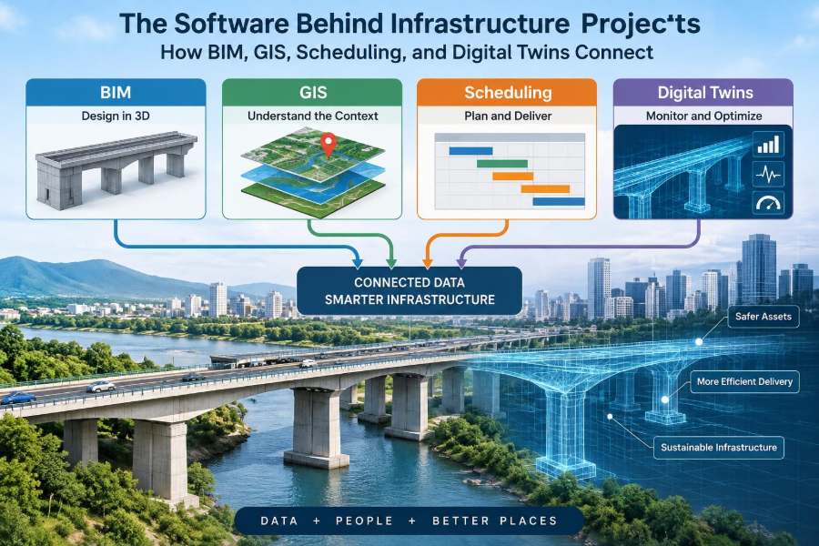
BIM, GIS, scheduling platforms, and digital twins are often discussed as separate technologies. In a well-managed project, however, they act more like connected lenses: one explains the asset, one explains its place, one explains its sequence, and one can help explain its real-world condition over time.
🏗️ Infrastructure Is an Information Problem
Infrastructure projects create physical assets, but they are managed through information. Engineers need dimensions, material specifications, survey control, design assumptions, approvals, quantities, risks, and records of what was actually installed.
A road corridor, rail extension, water-treatment plant, or flood-defense scheme also has many interfaces. Civil, structural, geotechnical, electrical, environmental, and operations teams must coordinate their work while responding to constraints outside the project boundary.
The central task is maintaining reliable connections between information sets, rather than treating every file as an isolated deliverable.
🧩 Four Systems, Four Primary Questions
Although individual products differ, the main roles are easy to distinguish. BIM asks what the asset is; GIS asks where it is; scheduling asks when work happens; and a digital twin asks what the asset is doing or how it is performing.
| System | Primary focus | Typical question |
|---|---|---|
| BIM | Object-based asset information | What components make up this structure? |
| GIS | Geographic location and spatial context | What lies around, above, or below this corridor? |
| Scheduling | Activities, logic, resources, and dates | What must happen before this task can start? |
| Digital twin | Connected representation through the asset life cycle | What is the asset’s current state, and what does it imply? |
These categories overlap. A BIM model can include coordinates, a GIS record can link to documents, and a digital twin may display a schedule. The distinction is useful because each system has different strengths and limitations.
🧱 BIM Defines the Asset
Building Information Modeling, or BIM, is an approach to creating and managing structured information about a built asset. Its visible model is usually three-dimensional, but BIM is not just 3D geometry.
A model element can represent a culvert, pier, retaining wall, pipe, valve, or precast panel. It may carry properties such as material, classification, dimensions, specification reference, installation status, and maintenance identifier.
For civil works, BIM is valuable when model objects are tied to purposeful information requirements. A visually detailed model with unreliable attributes is not automatically useful for construction or asset management.
📐 Geometry Is Not the Same as Engineering Truth
A model can look complete while still lacking design meaning. A generic rectangular shape may resemble a beam, but it does not necessarily contain the load assumptions, connection details, reinforcement information, or approved revision needed to build safely.
Likewise, a detailed model should not replace engineering judgment. Design calculations, specifications, inspection records, and formal approvals remain essential sources of authority.
Teams should define which information is authoritative for each decision. This prevents the common error of treating a convenient model view as the final contractual or technical answer.
🗺️ GIS Places the Project in Its Real Context
Geographic Information Systems, or GIS, organize information by location. They combine maps, coordinates, aerial imagery, terrain, land parcels, utilities, environmental constraints, traffic networks, and many other spatial datasets.
For a highway project, GIS may reveal floodplains, protected habitats, property boundaries, existing drainage routes, and the location of nearby public utilities. That context often shapes feasibility long before detailed structure models exist.
GIS is especially strong at working across a large area. A BIM model may describe one pump station precisely; GIS can show how that station relates to the catchment, pipe network, access roads, and surrounding communities.
📍 Coordinate Systems Need Early Attention
Spatial integration fails quickly when datasets use inconsistent coordinate reference systems, vertical datums, or units. A model can appear offset from survey data not because its geometry is wrong, but because its coordinate basis has been misunderstood.
Horizontal position and elevation deserve separate checks. A project may align acceptably in plan while showing a meaningful vertical discrepancy because one dataset uses a different height reference.
Before exchanging models, teams should agree on control points, coordinate conventions, units, and the approved transformation process. This is basic work, but it avoids expensive confusion later.
⏱️ Scheduling Turns Scope into a Workable Sequence
A schedule is more than a calendar of desired dates. It represents activities, durations, logical relationships, constraints, milestones, resources, and sometimes cost or risk information.
On a bridge project, piling must generally precede pile-cap construction; bearings must be available before girders are placed; and road surfacing may depend on waterproofing, drainage, and traffic-management windows. The schedule makes these dependencies visible.
A good schedule also exposes uncertainty. It does not eliminate weather risk, approvals, procurement delays, or access constraints, but it gives the team a structured way to assess their consequences.
🔗 The Critical Path Is a Management Tool, Not a Guarantee
The critical path is the chain of activities that determines the earliest forecast completion date under the schedule’s current assumptions. Delay to a truly critical activity can delay the project, while another delayed activity may have available float.
But criticality can change as work progresses. A late design decision, restricted possession window, or supply problem may shift the controlling sequence.
Schedules are forecasts based on logic and evidence, not promises generated by software. Their usefulness depends on realistic durations, current progress, and honest treatment of constraints.
🧭 Digital Twins Extend the Conversation Beyond Design
A digital twin is commonly described as a connected digital representation of a physical asset or system that is updated with relevant data through time. The phrase is used broadly, so teams should define what it means for their project.
A simple twin might combine an approved asset model with inspection histories and operational status. A more advanced implementation may incorporate sensor data, control-system information, maintenance records, and analytical models.
Not every project needs a highly dynamic twin. The right level depends on operational decisions, data quality, maintenance capability, and the cost of keeping information current.
📡 Sensors Provide Signals, Not Automatic Answers
Sensors can measure quantities such as vibration, displacement, water level, flow, temperature, strain, or equipment run time. These measurements can help operators identify changes that deserve investigation.
However, sensor data needs context. A higher reading may reflect temperature variation, a changed operating condition, calibration drift, or a developing defect. Interpretation requires engineering knowledge and suitable thresholds.
For example, a hypothetical pumping station twin might flag repeated starts and stops. That observation could point to control settings, changing demand, blockage, or instrumentation issues; it does not diagnose the cause on its own.
🔄 The Connection Starts with Shared Identifiers
Systems cannot reliably connect objects if each team names them differently. A valve called “V-204” in the model, “Valve 204A” in commissioning records, and “North zone valve” in maintenance logs becomes difficult to track.
Shared asset IDs, work package codes, location codes, and document references act like joining fields in a database. They allow a user to move from a map feature to an asset record, model object, inspection report, and related work order.
Identifiers should be stable, understandable, and governed. Changing them casually after handover can break valuable links.
🧾 Data Standards Make Exchanges Repeatable
Interoperability means different systems can exchange and use information with acceptable fidelity. It is rarely achieved by sending one file at the end of a project.
Teams need agreed definitions for classifications, naming, required attributes, status codes, file formats, coordinate systems, and revision handling. Open exchange formats can help, but they do not compensate for unclear requirements or poor source data.
A practical question is: what decision will this information support? Defining the answer helps teams avoid collecting attributes that nobody will use.
🛣️ A Corridor Project Shows Why Integration Matters
Consider a hypothetical urban road and drainage improvement scheme. GIS identifies low-lying areas, property interfaces, existing utility records, tree constraints, and roads available for detours.
BIM models the retaining walls, culverts, pipework, lighting foundations, and utility diversions. The schedule connects these objects to activities such as excavation, temporary support, pipe installation, testing, reinstatement, and traffic switches.
During operation, the owner may retain asset IDs, inspection records, drainage cleaning history, and water-level data in an appropriately scoped digital-twin environment. The value is the traceable chain from location to design intent to installed asset to maintenance decision.
🚧 Construction Uses 4D and 5D Carefully
When model objects are linked to schedule activities, teams often call the result 4D BIM. It can visualize construction sequence, temporary works, access conflicts, crane zones, or the changing availability of work fronts.
When cost information is linked as well, the term 5D BIM is often used. This can support quantity review, cost forecasting, and change assessment.
These labels are useful shorthand, not proof of control. A polished animation can conceal missing logic, outdated progress data, or estimates that have not been validated by commercial and construction teams.
🧠 Model Coordination Is More Than Clash Detection
Clash detection compares model geometry to find overlaps or insufficient clearances. It is valuable for identifying a pipe passing through a beam or a cable route conflicting with another service.
Many serious issues are not geometric clashes. They include unsuitable maintenance access, impossible construction sequence, unclear ownership of an interface, inadequate survey information, or a component that cannot be procured in time.
Coordination meetings work best when each issue has an owner, a decision deadline, evidence, and a recorded outcome. A long list of clashes without resolution management is only a list.
🌍 GIS Strengthens Environmental and Community Decisions
Infrastructure affects land, water, ecosystems, movement, and neighborhoods. GIS helps project teams analyze these relationships at a scale that individual discipline models cannot easily show.
It can support route comparison, catchment analysis, emergency access planning, construction-impact mapping, and communication with stakeholders. It also helps distinguish a local engineering solution from its wider spatial consequences.
Spatial datasets have limitations: utility records may be incomplete, imagery may be outdated, and environmental boundaries may require field verification. GIS informs investigation; it does not remove the need for it.
📦 Procurement Needs Structured Information Too
Long-lead items such as switchgear, bearings, pumps, fabricated steel, and specialized valves can control construction progress. Procurement teams need specifications, approved submittals, manufacturing status, delivery dates, and inspection requirements connected to the correct asset or work package.
Linking procurement status to the schedule can reveal whether a planned installation date is credible. Linking it to model objects can clarify exactly which location or system is affected.
Care is needed with supplier information. It must be checked, version-controlled, and retained in forms that the owner can use after commissioning.
✅ Quality Records Should Follow the Asset
Test certificates, concrete delivery records, weld inspections, pressure tests, photographs, and commissioning results are often stored by date, contractor, or folder. That can make future retrieval slow.
Where appropriate, quality evidence should also be linked to the installed element, system, or location. A maintainer investigating a buried pipeline repair benefits from finding relevant test and installation records without guessing which folder contains them.
This does not mean attaching every document to every object. Sensible indexing and clear retention rules are more useful than indiscriminate duplication.
🏁 Handover Is a Data Transition, Not a Final Upload
At handover, the owner needs information that supports operation, maintenance, warranty management, statutory duties where applicable, and future modifications. The contractor’s construction files may not be organized in the way operators need.
Asset information requirements should therefore be set early, tested during delivery, and reviewed before closeout. Waiting until the last month encourages missing data, rushed checking, and unusable records.
“As-built” information also needs care. It should represent verified installed conditions, not merely the final design model with a new filename.
🧰 The Common Data Environment Provides Control
A common data environment, often abbreviated to CDE, is a managed process and platform for sharing project information. It controls where information is stored, who can access it, what revision is current, and what approval or suitability status applies.
The purpose is not to force every team into one authoring tool. It is to ensure that published information is discoverable, traceable, and used according to its status.
Without this discipline, integration becomes risky: a schedule may reference an old drawing, field teams may build from a superseded model, or operations may inherit conflicting records.
👥 Roles Matter More Than Software Licenses
Successful digital delivery requires clear responsibilities. Designers author and check their information; survey teams establish spatial reliability; planners maintain schedule logic; contractors report progress; and owners define what information they need to operate assets.
Information managers and coordinators can establish processes, but they cannot replace technical accountability. The engineer responsible for a design decision remains responsible even when that decision appears in a shared model.
Training should include practical workflows: how to find the current information, raise an issue, interpret status codes, and report changes from site.
⚠️ Poor Data Quality Travels Fast
Connected systems can amplify errors. If an incorrect asset identifier is reused across platforms, it may link the wrong maintenance record, schedule activity, or map location to a component.
Common causes include uncontrolled copying, manual re-entry, ambiguous naming, rushed model updates, and inadequate validation. Integration should therefore include checks for completeness, uniqueness, consistency, and plausible values.
A small number of trusted fields is usually more valuable than a large database full of uncertain attributes.
🔒 Cybersecurity and Access Cannot Be an Afterthought
Digital infrastructure information can include operational layouts, equipment details, location data, and connections to monitoring or control systems. Access should reflect genuine need, particularly once systems move from construction information into operational environments.
Good practice includes managed user access, secure authentication, backups, audit trails, and clear procedures for suppliers and departing staff. Specific controls depend on the asset, organization, and applicable requirements.
Cybersecurity is not only a technology task. A careless file share or unreviewed account can undermine otherwise strong controls.
💰 Start with Decisions, Not a Technology Shopping List
A project should not pursue a digital twin, 4D model, or GIS dashboard simply because the term is fashionable. Begin by identifying recurring decisions that are currently slow, uncertain, or poorly evidenced.
For example, an owner may need faster access to inspection history for critical gates, while a contractor may need clearer visualization of temporary traffic stages. These are different problems and may require different levels of integration.
- Define the users and decisions.
- Identify the minimum trustworthy data needed.
- Assign ownership for creating, checking, and updating it.
- Test the workflow on a meaningful pilot.
- Expand only when the process delivers practical value.
🪜 Use a Proportionate Maturity Path
Not every organization needs the same digital maturity. A small rehabilitation project may gain most from consistent file control, reliable coordinates, a clear asset register, and a realistic schedule.
A complex rail, utility, or water network may justify deeper connections between models, spatial systems, field data, and operational analytics. The difference is not ambition; it is fit for purpose.
Building dependable fundamentals first makes advanced applications more credible. A sophisticated dashboard cannot repair missing survey control or undefined asset ownership.
🎓 Skills for Students and Early-Career Engineers
You do not need to become an expert in every platform. More valuable is learning how information flows between disciplines and asking precise questions about assumptions, status, coordinates, and source reliability.
Develop comfort with model viewing, basic GIS concepts, schedule logic, data tables, and field records. Then connect those skills to civil-engineering judgment: constructability, safety, drainage behavior, ground conditions, materials, and maintenance access.
Software proficiency opens doors, but the ability to recognize whether digital information makes engineering sense remains the core professional skill.
🔮 The Future Is Connected, Not Necessarily Centralized
Future projects will likely use more field capture, automation, remote sensing, and connected asset data. Yet a single perfect platform is unlikely to solve every infrastructure problem.
Different organizations have different responsibilities, legacy systems, security constraints, and operational needs. The practical goal is dependable exchange and governance, not forcing all information into one interface.
Open thinking, clear requirements, and disciplined stewardship will matter as much as the next software release.
🌉 The Core Principle: Connect Information to Decisions
BIM, GIS, schedules, and digital twins have the greatest value when each contributes what it does best. BIM describes assets, GIS explains their context, schedules organize delivery, and twins can support learning from operation.
They should be connected through agreed identifiers, coordinates, standards, responsibilities, and review processes. Just as importantly, teams must know when information is current, checked, and suitable for a particular purpose.
The aim is not a more impressive model or dashboard. It is better engineering decisions from planning through construction and into the long life of the asset.
Infrastructure becomes smarter when trustworthy information follows the asset, connects the people responsible for it, and supports decisions at the moment they are needed. 🌉🗺️⚙️