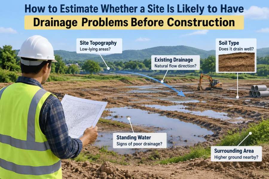

A plot can look perfectly buildable on a dry afternoon: level enough for a house, close to a road, and free of obvious standing water. Then the first prolonged storm arrives, and water collects against the proposed building line, the access track softens, or runoff crosses the site from land uphill.
Drainage problems are rarely caused by one visible feature alone. They emerge from the interaction of slope, soil, groundwater, upstream catchment, existing pipes and ditches, development layout, and the storms the site must accommodate.
For students, early drainage assessment is a useful exercise in reading a landscape. For working professionals, it is a way to identify questions that need investigation before drawings, earthworks, and drainage networks become expensive to change.
A desktop review and a site walk cannot replace a proper survey, infiltration testing, hydraulic design, or local approvals. They can, however, reveal whether a site deserves routine attention or a much more cautious drainage strategy.
🌧️ Start With the Right Question
The useful question is not simply, “Does this site flood?” A dry site may still have poor drainage, high groundwater, saturated subsoil, inadequate outlet capacity, or runoff that creates problems only during certain storms.
A better early question is: where does water arrive, where does it travel, where can it be stored or infiltrated, and where can it leave safely? This frames drainage as a site system rather than a pipe-sizing exercise.
Also distinguish between nuisance ponding and damaging flooding. A shallow puddle in an unused corner has different consequences from flow entering a basement, overtopping an access road, or eroding a neighboring property.
🗺️ Read the Site in Its Wider Catchment
Every site belongs to a catchment: the area from which rainfall drains toward a common low point. Water does not respect ownership boundaries, so a small parcel may receive runoff from fields, roads, roofs, or hills well beyond its edge.
Start by identifying the higher and lower ground around the site. A plot at the foot of a slope, in a shallow valley, or beside a drainage channel may be exposed to off-site flow even if its own surface appears gentle.
Mapping platforms, topographic data, and local contour plans are valuable screening tools. They should be checked on the ground, because small banks, culverts, walls, and altered land levels can redirect water in ways broad mapping does not show.
📐 Use Contours to Predict Flow Paths
Contours join points of equal elevation. Water generally moves perpendicular to contour lines, from high ground toward lower ground. Closely spaced contours indicate steeper terrain and often faster runoff; widely spaced contours suggest gentler gradients and potentially slower drainage.
Look for converging contours, which can indicate a swale or natural flow route. Diverging contours may describe a ridge, where water tends to split and move away. A proposed building placed in a convergence zone deserves particular scrutiny.
Do not assume a site that slopes is automatically well drained. A slope may shed surface water quickly while retaining water within shallow soil layers above an impermeable stratum.
🏞️ Identify Low Points, Hollows, and Closed Depressions
Water accumulates at low points unless there is a reliable outlet. Even a modest depression can become problematic after grading creates a bowl around a building, car park, or landscaped area.
On a walkover, look for subtle clues: a level area bounded by higher ground, a sag in a road, a gate at the bottom of a track, or vegetation that changes abruptly in a shallow hollow. These features often matter more than the site’s average slope.
Closed depressions require deliberate treatment. Filling them without providing a new flow route may merely move ponding elsewhere, while routing water out of them can affect land or infrastructure downstream.
🌊 Look Beyond the Site Boundary
Drainage failures often begin outside the development footprint. An uphill ditch may overtop, a blocked culvert may divert flow, or a neighboring site may discharge toward the boundary after redevelopment.
Walk the approach routes to the site where access is possible. Notice roadside gullies, field drains, channels, embankments, retaining walls, and driveways that could block or concentrate runoff. Ask where their water goes during intense rain.
A boundary wall can be especially revealing. Staining, debris caught on fencing, repaired sections, or small openings at ground level may indicate that water has previously crossed that line.
🧭 Separate Surface-Water, Groundwater, and River Risks
Not all wetness has the same source. Surface-water flooding occurs when rainfall flows or ponds over land. Groundwater problems arise when the water table rises or water moves through permeable layers. Fluvial flooding comes from rivers, streams, and channels exceeding their capacity.
These mechanisms can overlap. For example, saturated ground reduces infiltration during a storm, which increases surface runoff; high river levels can also prevent local ditches or pipes from discharging freely.
| Observed condition | Possible dominant mechanism | Early implication |
|---|---|---|
| Water marks after heavy rain | Overland runoff or blocked drainage | Trace upstream flow paths and outlets |
| Persistent wet ground in dry weather | High groundwater or spring line | Investigate groundwater and soil layers |
| Site beside a channel or floodplain | Fluvial flooding or backwater effects | Review flood mapping and channel behavior |
| Wet patches below a hillside | Seepage over a low-permeability layer | Assess subsurface flow, not just grading |
🪨 Understand What Soil Can and Cannot Absorb
Infiltration is the movement of water from the ground surface into soil. Sandy and gravelly soils often allow water through more readily than clay-rich soils, but soil behavior is never determined by texture alone.
Compaction, layering, made ground, fissures, organic material, and the depth to groundwater can change how a soil performs. A thin permeable topsoil over dense clay may accept water briefly and then become saturated.
Never select soakaways solely because a soil map suggests permeable ground. Preliminary mapping is useful for risk screening, but design decisions require site-specific investigation and testing by competent professionals.
🕳️ Watch for Made Ground and Filled Land
Made ground is land formed or altered by placing fill, demolition material, or excavated soil. It may be highly variable over short distances, with unpredictable drainage paths and potential settlement concerns.
Old quarries, landfill areas, former industrial land, and recently regraded plots require extra care. Surface appearance can conceal buried materials, old drains, voids, or compacted layers that interfere with drainage.
Historic mapping and ground investigation can help identify these conditions. Infiltrating water into uncertain fill may be unsuitable where it could mobilize contaminants, destabilize ground, or create hidden seepage routes.
🌱 Treat Vegetation as Evidence, Not Proof
Vegetation can provide useful clues. Reeds, rushes, mossy ground, water-tolerant plants, and stunted grass may suggest persistent moisture. Mature trees leaning downhill or exposed roots can also reveal erosion or shallow wet soils.
However, planting, irrigation, shade, maintenance, and seasonal conditions can mislead. A healthy lawn does not prove good drainage, and wetland-type plants may have been deliberately installed.
Use vegetation as one observation in a wider evidence set. When it aligns with low ground, staining, soft soils, and reports from nearby occupants, its significance becomes much stronger.
👣 Let Site Clues Tell Their Story
A careful walkover often reveals drainage history more clearly than a single drawing. Look for sediment fans, rills cut into bare soil, scour around structures, algae on paving, cracked pavement edges, and irregular settlement.
Inside existing buildings, signs can include damp lower walls, tide marks, corrosion near floor level, musty smells, or repeated repairs at thresholds. Such evidence does not identify the precise cause by itself, but it should trigger investigation.
Take dated photographs and record locations. Observations become far more useful when they can be compared with levels, weather records, drainage plans, and later site investigation.
🏠 Ask the People Who Know the Weather
Owners, neighbors, maintenance staff, farmers, and local road crews may know where water stands, which ditch blocks first, or whether a nearby culvert has a history of surcharging.
Ask open questions rather than seeking a preferred answer: Where does water come from? How long does it remain? What happens after snowmelt or prolonged rain? Have conditions changed since nearby development?
Personal accounts should be documented and checked, not treated as conclusive evidence. Memory can be incomplete, but local experience can identify events and flow routes that formal datasets have not captured.
📜 Review Flood and Drainage Records Carefully
Available flood maps and drainage records can identify mapped floodplains, surface-water susceptibility, watercourses, sewer assets, and known constraints. Their usefulness depends on scale, date, modeling assumptions, and the type of flooding represented.
An unmapped site is not necessarily risk-free. Small watercourses, blocked culverts, local topographic depressions, and drainage failures may fall below the resolution of broad datasets.
Conversely, mapped susceptibility is not a prediction that flooding will certainly occur. Treat records as a reason to investigate mechanisms, elevations, access, and mitigation options in greater detail.
🧱 Find Existing Drains, Ditches, and Culverts
Existing drainage infrastructure can be an asset or a hidden constraint. A ditch may provide an outlet, but it may also require maintenance, have limited capacity, or carry flow from elsewhere. A culvert may be undersized, damaged, or difficult to inspect.
Locate visible gullies, manholes, outfalls, channels, and pipe inlets. Plans can be incomplete, particularly on older sites, so service tracing and surveys may be necessary before finalizing layouts.
Never assume an existing pipe is suitable for additional discharge. Its condition, ownership, receiving system, gradient, downstream capacity, and legal right to connect all need confirmation.
🚧 Notice Barriers That Redirect Water
Road embankments, raised driveways, fences with solid boards, retaining walls, and building platforms can act like small dams. They may protect one area while trapping water or concentrating it at an unprotected point.
This is common when a site is raised above surrounding land without a coherent edge-drainage strategy. Water formerly crossing the site may then be diverted toward neighbors or along the new access route.
Think in sections as well as plans. A cross-section through the boundary, road, and proposed building often exposes drainage conflicts that a flat site plan hides.
🏗️ Estimate How Development Changes Runoff
Roofs, roads, patios, and compacted construction areas usually shed water faster than vegetated soil. The issue is not only total runoff volume; it is also the speed and concentration with which runoff reaches low points or drains.
Construction can change levels, remove vegetation, compact soil, and interrupt natural pathways. A site that appears acceptable before work may become problematic after grading if runoff is not managed from the earliest construction stages.
Early concepts should compare existing and proposed flow patterns. Ask where rainfall will go when every roof, parking area, and access surface is complete.
💧 Think in Terms of Storage, Flow, and Discharge
A robust drainage concept usually combines three functions: capture water, convey it safely, and provide temporary storage or infiltration before controlled discharge. The balance depends on local ground conditions and downstream constraints.
Storage features such as basins, tanks, oversized pipes, and landscaped swales can reduce peak flow. They are not decorative extras; they allow a system to respond more slowly than the storm.
The receiving location matters. An outlet that works in ordinary weather may fail when a river, sewer, or ditch is already high. This is called a downstream or tailwater constraint.
🧪 Know When Infiltration Testing Is Needed
Where infiltration drainage is proposed, field testing is generally needed to establish whether the ground can accept water at the intended depth and location. A test result from one corner should not automatically represent an entire variable site.
Testing must reflect seasonal groundwater and soil conditions as far as practical. Very dry ground may initially absorb water quickly, while wetter conditions can reveal slower long-term performance.
Professional interpretation is essential because infiltration is also a geotechnical question. Water placed near foundations, slopes, retaining structures, contaminated ground, or unstable soils can create risks beyond ponding.
📏 Get Reliable Levels Before Designing Solutions
Drainage depends on small differences in elevation. A few centimeters can determine whether water reaches a gully, bypasses it, flows toward a doorway, or sits in a landscaped low point.
A proper topographic survey should capture site boundaries, buildings, hard surfaces, channels, utility covers, road levels, visible drainage features, and relevant off-site ground. The survey needs an appropriate datum so that levels can be compared reliably.
Designing from rough online elevations is acceptable only at the earliest screening stage. It is not a substitute for surveyed levels when setting floor levels, pipe gradients, storage depths, or flood routes.
🚪 Protect Buildings With Thoughtful Finished Levels
Finished floor level is the designed elevation of the occupied floor. Setting it appropriately above surrounding ground and anticipated external water levels is one of the most direct ways to reduce entry risk.
But raising a building alone is not a complete solution. Doors, ramps, service entries, basements, garages, and accessible routes can create lower vulnerable points. The raised structure may also displace water toward adjacent land.
External grades should fall away from the building where feasible, while still directing water to planned drainage routes. Avoid relying on thin surface channels that can clog, settle, or be altered during landscaping.
🌿 Use Green Features for the Right Reasons
Swales, rain gardens, permeable paving, green roofs, and detention basins can manage runoff close to where it falls. They can also improve amenity and reduce the burden on conventional pipe networks.
These features are not universally suitable. Permeable paving may need careful sub-base design and maintenance; rain gardens need appropriate planting and overflow routes; swales need enough space and safe side slopes.
Green drainage works best when integrated into the site layout early. Trying to insert it into leftover strips of land often produces features that are too small, too steep, or difficult to maintain.
🛣️ Check Access Routes and Emergency Movement
A building may remain dry while its access road, pedestrian route, or utility corridor becomes impassable. Drainage assessment should therefore include the route to and from the site, not only the building footprint.
Low road sags, underpasses, bridge approaches, and crossings of small channels can become the weak link during severe weather. Construction traffic can also damage verges and roadside drains, increasing later runoff problems.
Consider how occupants, deliveries, emergency services, and maintenance crews would move if the normal drainage route is overwhelmed. Safe exceedance planning is part of resilient design.
🔄 Plan Safe Exceedance Routes
No practical drainage system can be assumed to perform perfectly in every storm or under every blockage condition. An exceedance route is the planned path water follows when designed drainage capacity is exceeded.
Ideally, excess water should move away from buildings, deep excavations, electrical equipment, and vulnerable neighbors toward areas that can tolerate temporary inundation. Roads or landscaped corridors may sometimes serve this role if designed safely.
The key is to make the route intentional. Without one, water will choose its own path—often through the lowest opening in a building or along the most damaging available route.
🧰 Include Construction-Phase Drainage
Temporary drainage is frequently overlooked. During construction, stripped topsoil, stockpiles, wheel ruts, open trenches, and partially completed surfaces can generate muddy runoff far greater than the finished site would produce.
Plan temporary swales, silt controls, pumping arrangements where necessary, stabilized access, and inspection after rainfall. Keep temporary discharge away from excavations and avoid allowing sediment to enter public drains or watercourses.
A permanent drainage design cannot solve problems caused by poor site management before that permanent system is operational.
🔍 Recognize Red Flags That Need Specialist Input
Some observations should move a project beyond preliminary screening quickly. They do not mean construction is impossible, but they increase the need for qualified hydrological, drainage, geotechnical, environmental, or structural advice.
- Evidence of past flooding, active erosion, or repeated ponding.
- A watercourse, culvert, ditch network, or floodplain near the site.
- High groundwater, springs, seepage zones, or persistent wet ground.
- Steep slopes, retaining structures, unstable ground, or deep excavations.
- Made ground, contamination concerns, or uncertain buried infrastructure.
- No obvious lawful or physically reliable discharge route.
Early specialist work is often less disruptive than redesigning a building after drainage constraints have already fixed the layout.
⚠️ Avoid the Most Common Early-Stage Mistakes
One common mistake is visiting only in dry weather and treating the absence of water as evidence of low risk. Another is focusing exclusively on the building plot while ignoring the upstream catchment and downstream outlet.
Teams also sometimes assume that adding more pipes is the answer. Pipes can convey water efficiently, but they do not create capacity in a blocked outlet, a full river, or an already overloaded downstream system.
Finally, avoid treating drainage as a late utility coordination task. Ground levels, open space, road geometry, floor levels, and plot arrangement can determine whether a practical drainage solution exists.
📝 Build an Early Drainage Risk Register
A short risk register turns scattered observations into decisions. Record the issue, evidence, possible consequence, uncertainty, and the action needed to reduce that uncertainty.
For example, “wet area at southwest boundary” is an observation. A useful risk entry adds possible causes—seepage, blocked ditch, or low ground—and identifies next steps such as a level survey, drainage inspection, or seasonal groundwater monitoring.
This approach prevents assumptions from becoming embedded in drawings. It also helps clients understand why further investigation is proportionate rather than optional.
🧩 Combine Desktop Review, Walkover, and Investigation
No single method gives a dependable answer. Desktop information identifies broad patterns and known constraints. A walkover tests whether those patterns make sense on the ground. Surveys, testing, and specialist assessment quantify the conditions that matter for design.
Think of the process as narrowing uncertainty. Early observations do not need to solve every hydraulic question; they need to identify whether the proposed development is compatible with the site and what evidence is missing.
When the three sources disagree, investigate the disagreement. A map may show a flow path that has been altered, or a dry-looking site may conceal an old drainage system that changes the picture.
🤝 Coordinate Drainage With the Whole Design Team
Drainage affects architecture, highways, landscape, structures, utilities, ecology, and construction planning. Coordination is most effective before plot levels and building footprints are fixed.
Landscape designers may provide storage and flow routes; structural engineers may advise on foundation and infiltration constraints; highway designers may control road drainage; geotechnical teams may explain soil and groundwater behavior. None of these disciplines can work in isolation.
A coordinated concept is usually simpler than a collection of late additions. It also makes maintenance responsibilities clearer once the project is complete.
🛠️ Remember That Maintenance Is Part of Capacity
A drainage feature works only while it remains functional. Gullies fill with sediment, swales become overgrown, permeable surfaces clog, and outfalls can be obstructed by debris or vegetation.
Design should therefore include practical access for inspection and cleaning. A storage chamber that cannot be reached, or a ditch behind locked private gardens, may be difficult to maintain when it matters most.
Maintenance plans should identify who is responsible, what must be inspected, and what signs trigger action. This is especially relevant where a system relies on visible landscape features rather than hidden pipes.
✅ Turn Early Observations Into a Go/No-Go Decision
At concept stage, the goal is not to certify a site as “safe” or “unsafe.” The goal is to decide whether drainage risk appears manageable, manageable only with defined mitigation, or too uncertain to proceed without major investigation.
A site may remain viable with raised levels, detention storage, protected flow routes, improved outfalls, or a revised building location. Another may be constrained because no safe discharge route exists or because development would worsen risk elsewhere.
The core principle is simple: estimate drainage risk by following water across the real landscape, through the soil, around existing infrastructure, and beyond the site boundary before committing to the design.
Good early drainage judgment does not eliminate uncertainty; it makes uncertainty visible early enough to investigate, design responsibly, and avoid creating avoidable problems for people on and around the site. 🌧️🏗️🌿