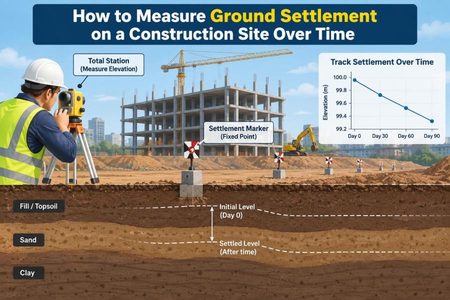

A newly placed slab looks level on Friday. Several weeks later, a door frame is binding, a drainage channel no longer falls toward its outlet, or survey readings show that one point has moved lower than another. The ground has not necessarily “failed,” but it may be settling.
Settlement is common in civil engineering because soil is not a rigid material. It compresses, rearranges, drains, and responds to changes in load and groundwater. The question on a construction site is rarely whether any movement will occur; it is whether the movement is within the assumptions used for design.
Measuring settlement over time turns an uncertain concern into evidence. A well-planned monitoring program can show how much the ground has moved, where movement is concentrated, whether the rate is slowing, and whether the response should change.
This work is more than taking occasional level readings. Reliable results depend on stable reference points, repeatable methods, appropriate instruments, careful records, and engineering interpretation.
🧭 What Ground Settlement Means
Ground settlement is the downward vertical movement of the ground surface, a foundation, or an engineered fill. It can occur beneath a building, embankment, pavement, crane pad, utility trench, or temporary works.
A settlement value is normally reported as a change in elevation relative to a reference datum. If a monitoring point drops 12 mm relative to a stable benchmark, its settlement is 12 mm. The sign convention should be stated clearly, because project teams may record downward movement as either negative elevation change or positive settlement.
📐 Why the Pattern Matters More Than One Reading
A single reading tells you the position of a point on one day. A sequence of readings tells you the behaviour of the ground. That distinction is central to monitoring.
For example, 5 mm of settlement that develops gradually and slows over months may be consistent with consolidation predicted in design. The same 5 mm occurring over a few days after excavation, dewatering, or a heavy load is a different engineering situation.
Engineers assess both magnitude and rate of movement. They also compare points to identify differential settlement, where different areas move by different amounts.
🏗️ Where Settlement Monitoring Is Usually Needed
Monitoring is selected where ground conditions, structural sensitivity, or construction activities create a credible movement risk. It is particularly useful when observations can guide decisions rather than merely document a problem after it occurs.
- Buildings founded on soft clay, loose fill, peat, or variable made ground
- Embankments, approach fills, roads, and rail corridors over compressible soils
- Excavations beside existing structures or buried utilities
- Areas affected by groundwater lowering, tunnelling, mining, or deep compaction
- Land reclamation, surcharge preloading, and ground-improvement projects
- Slabs, pavements, tanks, and equipment foundations requiring tight tolerances
The monitoring scope should be proportionate. A small low-risk slab does not need the same instrumentation network as a major embankment near occupied buildings.
🪨 The Main Physical Causes of Settlement
Settlement has several mechanisms, and more than one can act at the same site. Immediate settlement occurs as soil deforms promptly under loading, particularly in granular soils. It can begin during construction.
Primary consolidation is common in saturated fine-grained soil. When new load is applied, excess pore-water pressure develops; water then drains out over time, allowing the soil skeleton to carry more load and compress.
Secondary compression is longer-term deformation after primary consolidation becomes small. Organic soils and some soft clays can be particularly susceptible. Other contributors include collapse of loose wettable soils, decomposition of organic matter, leakage from services, erosion, and shrink-swell movements in expansive clays.
⚖️ Total Settlement and Differential Settlement
Total settlement is the vertical movement at one location. Differential settlement is the difference in movement between locations. Structures often tolerate some uniform downward movement better than uneven movement.
Imagine a rigid picture frame resting on a table: lowering the whole table evenly changes its elevation but not its shape. Lowering only one corner twists the frame. Similarly, differential movement can cause cracking, distorted openings, service connection strain, and unwanted ponding.
For this reason, settlement points should not all be placed in one convenient line. Their layout must reveal the gradients and zones of movement that matter to the asset.
🎯 Start With Monitoring Objectives
Before choosing equipment, define what the monitoring program must answer. Vague instructions such as “monitor settlement” often produce data that are difficult to interpret or act upon.
- Establish baseline ground or structure levels before work starts
- Check whether preloading is producing the expected consolidation response
- Protect nearby assets during excavation or groundwater control
- Verify formation levels and performance of engineered fill
- Provide trigger information for inspection, review, or changes in construction activity
Objectives determine where points go, how accurate measurements need to be, how often readings are taken, and who receives the results.
🗺️ Build a Monitoring Plan Before Site Work Begins
A monitoring plan should connect the ground model, design assumptions, construction sequence, and response procedures. It is not simply a drawing showing dots on a site plan.
Document each instrument or point identifier, coordinates, initial level, installation detail, survey method, reading frequency, responsible party, required checks, and reporting route. Include planned construction stages, such as surcharge placement or excavation depth, because these give context to later readings.
Also identify the practical hazards: traffic, plant, stockpiles, temporary fencing, and access restrictions can all damage or obscure monitoring points.
📍 Establish a Stable Vertical Datum
Every settlement reading is only as trustworthy as its reference. A benchmark is a point of known or adopted elevation used as the datum for levelling. If the benchmark moves, apparent settlement may simply be movement of the reference.
Place primary benchmarks outside the anticipated zone of influence of loading, excavation, pumping, vibration, and general site disturbance. Their stability should be assessed in relation to local geology and project activities, not assumed because they are near a site boundary.
Use more than one reference where the risk justifies it. Re-observing independent benchmarks helps identify a reference point that has shifted.
🔁 Verify Benchmarks Instead of Trusting Them Blindly
Benchmark verification is a quality-control task, not an optional extra. A closed levelling loop, run between known points and back to the starting point, provides a check on accumulated observational error.
If a benchmark shows unexplained movement relative to other stable references, investigate before revising all monitoring results. Possible causes include physical disturbance, poor monument installation, frost or seasonal soil movement, or a survey blunder.
Never “correct” inconvenient readings without retaining the original data and recording the reason for any adjustment. Traceability is essential when movement data inform safety or contractual decisions.
📌 Choose Settlement Point Locations Carefully
Settlement points should represent the features and ground zones that need to be understood. A regular grid may suit a large fill platform, while a building may need points at corners, along load-bearing lines, near joints, and beside sensitive service entries.
For an embankment, typical locations include the centreline, toes, shoulders, and selected transverse sections. These positions can reveal whether settlement is concentrated beneath the central load or whether lateral ground movements may also be relevant.
A point located where it is easy to observe but unrelated to the expected movement pattern has limited value.
🔩 Use the Right Type of Surface Marker
A simple settlement marker may be a robust metal pin, bolt, or capped rod installed flush with a pavement, slab, or protected ground surface. It must be identifiable, accessible, and sufficiently well fixed that the marker itself does not wobble or pull out.
In soft ground and fills, a settlement plate can be used. A plate placed at a selected elevation is connected to a riser pipe that extends upward as fill is placed. Surveying the pipe top, while accounting for its fixed relationship to the plate, indicates settlement at the plate level.
Protection is part of the installation. Clearly mark points, but avoid creating a vulnerable obstruction in active haul routes.
🧱 Know the Limits of Surface Measurements
Surface points show movement at or near the surface. They do not directly reveal how much compression occurs within each soil layer. A surface drop might result from compression deep below, shallow fill settlement, or a combination of mechanisms.
Where the project needs depth-specific information, engineers may supplement surface points with borehole extensometers, magnetic settlement systems, or other subsurface instruments. These require specialist installation and interpretation but can separate movement in fill, soft clay, and deeper strata.
More instrumentation is not automatically better. Each device should answer a defined question and have a realistic maintenance plan.
🔭 Differential Levelling: The Core Method
Differential levelling with an optical level or digital level remains a dependable way to measure vertical movement over relatively short site distances. The instrument is set up between a backsight point of known elevation and a foresight point being observed.
The elevation difference is calculated from staff readings. Repeating this process through a controlled route gives elevations for settlement markers. A digital level with a bar-coded staff can reduce reading and transcription errors, but it does not replace sound field procedure.
Keep sight lengths reasonably balanced where practical, use a stable tripod setup, and avoid observations through strong heat shimmer or heavy rain when precision is needed.
📡 GNSS and Total Stations: Useful but Different
GNSS, commonly called GPS in everyday conversation, can provide coordinates quickly across large sites. However, vertical results are usually less precise and more sensitive to setup, satellite geometry, correction service quality, and site obstructions than careful precise levelling.
A robotic total station can repeatedly observe prisms and is valuable for automated or high-frequency monitoring. It measures angles and distances, then calculates position relative to a control network.
These methods are powerful for broad deformation monitoring, but they must be matched to required resolution. If the action threshold is only a few millimetres, verify that the complete system can reliably distinguish real movement from measurement noise.
🧰 Basic Field Procedure for Level Surveys
Consistency makes time-series data comparable. A practical field procedure should be written down and followed by all survey staff.
- Inspect benchmarks and settlement markers for damage, looseness, burial, or obstruction.
- Set up the level on firm ground with a clear view of the route.
- Take a backsight on the benchmark and calculate or confirm the height of instrument.
- Read each settlement point using the same marker detail and staff placement method.
- Close the route on a benchmark or check point and review the closure before leaving site.
- Record weather, construction activity, groundwater changes, and any unusual conditions.
Where readings are repeated, use stable staff footing. A staff pressed into soft soil can produce a convincing but false settlement value.
🧮 Calculate Elevation Change and Settlement
Let the initial elevation of a point be E₀ and its elevation at a later reading be Eₜ. If downward settlement is reported as a positive value, then:
Settlement, S = E₀ − Eₜ
If the point originally measured 102.436 m and later measures 102.421 m, the calculated settlement is 0.015 m, or 15 mm. Retain elevations to an appropriate number of decimal places during calculation, then report movement in a unit that matches project practice.
For differential settlement between points A and B, compare their individual settlements or directly calculate the change in their elevation difference over time.
📈 Calculate the Rate of Settlement
The average rate over an interval is the change in settlement divided by elapsed time:
Average rate = (S₂ − S₁) / (t₂ − t₁)
Rate is often expressed in millimetres per day, week, or month. The time unit should be selected to suit construction pace and the expected mechanism.
Do not overinterpret a rate based on two close readings if the movement is similar to survey uncertainty. A trend from several quality-checked observations is more informative. Plotting cumulative settlement against time makes acceleration, deceleration, and sudden steps easier to see.
📊 Present Data So Decisions Are Possible
A clear monitoring report separates observations from interpretation. Include a plan showing point locations, a table of current and cumulative movements, time-settlement plots, survey closure information, and notes on relevant site activities.
| Field | Why it is needed |
|---|---|
| Point ID and location | Prevents ambiguity about which feature moved |
| Date and time | Connects movement with construction stages and rainfall |
| Elevation and cumulative settlement | Shows the measured position and change from baseline |
| Interval rate | Highlights whether movement is speeding up or slowing down |
| Quality notes | Records closure, access issues, damaged points, and anomalies |
Graphs should show units, datum, and dates clearly. A graph without construction events can hide the reason a trend changed.
🚦 Set Alert, Action, and Stop Thresholds
Thresholds convert monitoring into a management tool. They should be established by the responsible designer or geotechnical engineer based on predicted performance, structural tolerance, construction method, instrument capability, and consequences of movement.
A common framework distinguishes an alert level requiring review or increased monitoring, an action level requiring defined mitigation or engineering assessment, and a stop or alarm level requiring immediate escalation and potential work suspension.
Thresholds should consider rate as well as total movement. A modest but rapidly increasing settlement rate can warrant attention before a total-movement limit is reached.
⏱️ Select Reading Frequency by Construction Risk
There is no universal survey interval. Readings should be more frequent during activities likely to alter stress or groundwater conditions: placing fill, increasing surcharge, excavation, dewatering, pile driving, or removing supports.
Once behaviour becomes slow and stable, monitoring may be reduced under an approved plan. Conversely, unexpected movement, heavy rainfall, a burst water main, or nearby excavation may justify additional readings.
Sampling too infrequently can miss a short-lived but meaningful event. Sampling extremely often without quality control can create a large dataset with little additional confidence.
🌧️ Record Conditions That Influence Results
Settlement measurements make more sense when they are paired with a site diary. Record fill thickness placed, vehicle loading changes, excavation stages, pumping rates where relevant, visible cracks, water levels, rainfall observations, and unusual vibration.
Environmental effects can matter. Temperature may affect long rods, pipes, and exposed structural elements. Wet ground can soften beneath a staff, while glare and heat haze can impair readings. These influences do not make measurement impossible; they make disciplined documentation necessary.
A useful report asks, “What happened between these dates?” rather than presenting numbers in isolation.
🔍 Distinguish Real Movement From Bad Data
An isolated jump in one point may be real, but it may also come from a bent riser, displaced pin, incorrect staff reading, transcription error, changed benchmark, or instrument setup problem. Treat anomalies as observations requiring investigation, not as numbers to erase.
Check the raw field notes, route closure, benchmark stability, point condition, and adjacent measurements. Re-observe promptly if safe and practical. If a point has been physically disturbed, document the event and establish a defensible new baseline only with engineering approval.
Data validation is not the same as making data look smooth. Genuine ground behaviour can be irregular.
🧱 Monitor Fill Placement and Preloading
Engineered fill can settle due to compression, particle rearrangement, inadequate compaction, or compression of the natural soil beneath it. Survey points may be installed at formation level, on the completed surface, or at selected interfaces depending on the question being investigated.
With preload or surcharge, added temporary weight intentionally accelerates consolidation before the permanent structure is built. Settlement plates and pore-pressure monitoring may be used together, because settlement alone does not always show whether excess pore pressure has dissipated sufficiently for the next stage.
Removal of surcharge should follow the project’s approved criteria, not a visual impression that the site has “stopped moving.”
🏠 Watch Nearby Buildings and Utilities
When construction occurs close to existing assets, surface settlement points may be placed on walls, pavements, utility corridors, and ground between the works and the asset. The aim is to identify spatial patterns early.
Building monitoring may also include crack gauges, tilt sensors, and internal floor-level surveys. These measure different responses: a settlement point records vertical displacement, while a crack gauge records change across a crack.
Utilities require particular care. Differential movement can strain rigid pipes and joints even where the surrounding surface settlement appears small. Coordinate observations with asset owners and the project’s approved protection measures.
🕳️ Understand Groundwater and Excavation Effects
Lowering groundwater can increase effective stress in some soils, leading to consolidation and settlement. Excavation can also unload ground locally while changing support conditions around the excavation perimeter. The resulting movements may be complex.
Settlement monitoring is therefore often paired with piezometers, which measure groundwater or pore-water pressure, and with lateral-movement instruments where retaining walls are involved. No single instrument explains the whole ground response.
Interpret readings in relation to the excavation sequence, water-control system, and geotechnical baseline. A downward trend alone does not prove a specific cause.
👷 Protect Instruments and Manage Access
Many monitoring programs fail through ordinary site damage rather than sophisticated technical errors. Markers are paved over, riser pipes are struck by plant, prisms are moved, and access disappears behind stored materials.
Brief site teams on what each point is and why it matters. Use durable labels, protective covers where appropriate, and coordinates or sketches that allow points to be found. Include monitoring assets in permit, excavation, and traffic-management discussions.
If protection conflicts with safe access, redesign the installation. An inaccessible instrument cannot provide dependable monitoring.
🧑🔧 Define Roles and Communication Routes
Monitoring involves several roles: survey personnel collect data, site staff protect installations and report events, engineers interpret trends, and project managers ensure that response actions occur. Confusion between these roles creates delays.
The plan should name who can declare an alert, who must receive notifications, and who has authority to alter the work sequence. It should also state how quickly escalations are made and where the latest approved results are stored.
A surveyor can report a measured change accurately, but decisions about structural or geotechnical acceptability require appropriate engineering responsibility.
⚠️ Common Mistakes That Undermine Monitoring
- Using a benchmark inside the moving zone: this can hide actual settlement or create false movement.
- Starting after construction begins: without a baseline, later change is difficult to quantify.
- Measuring only one location: this cannot reveal differential settlement across an asset.
- Changing methods without overlap: a new instrument or datum can create an artificial step in the record.
- Ignoring survey closures: precise-looking figures may still be unreliable.
- Reporting data without construction context: the team cannot connect trends to possible causes.
- Waiting for a total limit: accelerating rates may need attention earlier.
Most of these errors are preventable through planning, field discipline, and routine review.
🛠️ When Settlement Readings Need a Response
A threshold exceedance does not automatically identify the cause or prescribe one remedy. First confirm the data and assess the immediate condition of affected works. Then involve the responsible engineer to review the trend, ground conditions, and ongoing activities.
Possible responses may include increasing monitoring frequency, pausing a construction stage, modifying loading sequence, reviewing dewatering, improving drainage, adjusting surcharge duration, or undertaking further investigation. The suitable action depends on the mechanism and design intent.
Do not treat monitoring as a substitute for design review. It is an observational tool that supports informed intervention.
📚 Keep a Defensible Monitoring Record
Maintain original field notes, digital observations, calibration records where applicable, benchmark checks, installation photos, point sketches, calculations, plots, correspondence, and records of decisions. Version control matters when reports are updated.
A defensible record allows another engineer to understand what was measured, how it was measured, and why conclusions were reached. It is especially valuable when personnel change or questions arise long after construction.
Good records also make handover easier when monitoring continues into an operational period.
🧠 Match Precision to the Engineering Question
Every measurement has uncertainty. The goal is not to claim impossible precision, but to select a method whose repeatability and control are suitable for the movement that must be detected.
If expected movement is large and gradual, a robust conventional approach may be sufficient. If the project needs to distinguish millimetre-scale changes, use appropriate equipment, stable control, competent operators, short and controlled survey runs, and repeat observations.
Report results with sensible rounding. More decimal places do not create more certainty.
✅ The Core Principle: Measure, Compare, Interpret, Act
Effective settlement monitoring follows a simple chain: establish a stable baseline, measure repeatedly with controlled methods, compare changes across time and location, interpret them against ground behaviour and construction activity, then act through agreed procedures.
The strongest programs combine practical surveying with geotechnical judgement. They recognise that a number is not a conclusion: it is evidence that must be checked against reference stability, measurement quality, design expectations, and the observed site condition.
When this chain is maintained, settlement monitoring helps teams see change early enough to make proportionate, well-supported decisions.
Reliable settlement measurement is not about collecting the most readings; it is about collecting comparable readings from stable references and turning them into timely engineering decisions. 🌉📏👷