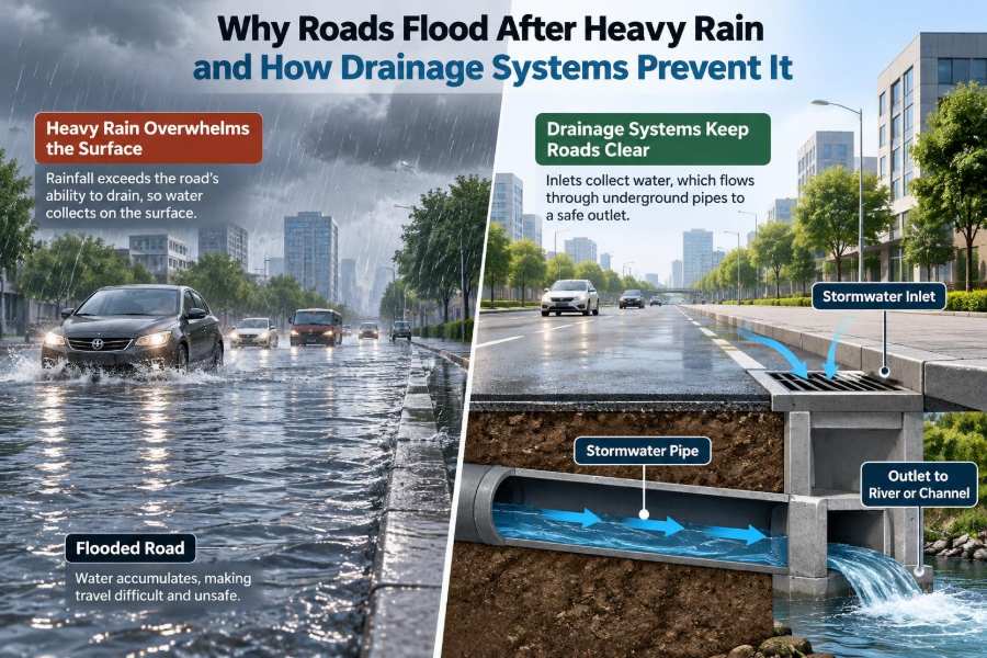

A sudden downpour can turn an ordinary commute into a slow-moving queue of vehicles, spray, standing water, and uncertainty. A road that looked perfectly dry an hour earlier may develop deep puddles at kerbs, under bridges, and at low points in the carriageway.
It is tempting to blame the rain alone. But heavy rainfall becomes a road-flooding problem when water reaches the surface faster than the road, its drainage network, and the surrounding ground can safely receive and carry it away.
For drivers, flooding reduces visibility, traction, and control. For engineers, it reveals how pavement shape, inlet placement, pipe capacity, maintenance, land use, and the design storm all work together—or fail together.
Understanding the drainage system beneath and beside a road helps explain why some routes recover quickly after a storm while others flood repeatedly. It also shows why the best solution is rarely just “install a bigger pipe.”
🌧️ Rainfall Is Only the Beginning
Rain falling on a road is called precipitation input. Flooding begins when that input exceeds the system’s ability to infiltrate, store, convey, or discharge water. The mismatch may last only a few minutes, but it can still create dangerous ponding.
Engineers consider both rainfall intensity and duration. A brief, intense cloudburst can overwhelm road gullies even if the total rainfall is modest, while a long storm can saturate soil and fill storage systems before the heaviest rainfall arrives.
🛣️ Roads Behave Like Impermeable Catchments
Most road surfaces are effectively impermeable. Dense asphalt and concrete allow very little water to soak through, so much of the rain becomes runoff: water flowing over the surface toward a drain, verge, ditch, or low point.
A road therefore acts like a small catchment basin. Its lanes, shoulders, footways, medians, adjacent slopes, and sometimes nearby properties can all direct water to the same inlet. The area feeding one drain may be much larger than it appears from the kerb.
💧 Runoff Forms Faster on Paved Surfaces
On natural ground, vegetation can intercept some rain, surface depressions can temporarily hold it, and soil can absorb part of it. On smooth pavement, these delays are limited. Water begins moving almost immediately, especially on steep grades.
This is why urbanization changes flood behavior. Replacing soil, trees, and open ground with roads, roofs, and parking areas increases both the volume of runoff and the speed at which it reaches drains.
📐 Road Crossfall Guides Water Sideways
Roads are not meant to be flat from side to side. They are built with a crossfall, also called camber on some road types, so water moves laterally toward the kerb, channel, edge drain, or verge.
If the crossfall is too small, water drains slowly and may spread across traffic lanes. If it is poorly constructed or altered by resurfacing, shallow hollows can remain even where the overall road appears correctly sloped.
⬇️ Longitudinal Grade Carries Water Along the Kerb
The slope along the direction of travel is the longitudinal grade. Once water reaches the edge of the carriageway, this slope guides it along the kerb channel toward a gully or inlet.
Near level roads are particularly sensitive. Water may have a clear sideways path to the kerb but little energy to travel along it. Inlets must then be placed carefully, because a small low spot can collect a surprisingly wide sheet of water.
🕳️ Low Points Are Natural Ponding Locations
Every drainage layout must identify sag points: locations where the road profile falls from both directions toward one low point. Underpasses, tunnel approaches, and depressed intersections are familiar examples.
At a sag point, water cannot continue along the road surface once it reaches the lowest elevation. It must enter an inlet system or be stored temporarily. If the inlet clogs, the pipe surcharges, or the outlet is blocked, water depth can rise rapidly.
🚧 Kerbs Can Help—and Trap—Runoff
Kerbs organize surface drainage by keeping runoff in a predictable channel near the edge of the road. They also protect verges and footways from routine sheet flow.
However, a continuous kerb prevents water from escaping sideways to lower ground. This is useful only when the kerb channel and its inlets have enough capacity. At a blocked inlet, the kerb can effectively guide more and more water toward the same flooded point.
🧱 Pavement Defects Create Small Flooding Problems
Rutting, settlement, utility trench patches, failed joints, and uneven overlays create local depressions. These may hold water even when the main drainage system is functioning properly.
Such defects matter beyond inconvenience. Repeated standing water can accelerate pavement deterioration, obscure lane markings, and create splash or spray hazards. A drainage investigation should therefore include a detailed survey of pavement levels, not only an inspection of pipes.
🌪️ Inlets Are the Gateway Into the Drainage Network
Gullies, catch basins, grated inlets, and kerb openings are the points where surface runoff enters underground drainage. Their task is not merely to receive water; they must intercept flow before it spreads too far into the roadway.
Inlet performance depends on its shape, grate openings, position, approach flow, local slope, and water depth. During intense rain, some water may flow past an inlet if the gutter flow is too fast, too deep, or bypasses the opening.
🍂 Debris Turns a Designed System Into a Restricted One
Leaves, litter, sediment, grass cuttings, and road grit commonly accumulate at inlet grates. Even partial blockage can greatly reduce entry capacity because water must pass through the remaining open area.
Maintenance crews often focus on pipes, but the visible inlet is equally critical. A large downstream pipe cannot help if water cannot enter it. Before a forecast storm, clearing known trouble spots can be more effective than waiting for ponding to develop.
🧺 Catch Basins Separate Sediment From Flow
Many roadside drainage structures include a sump or catch basin below the outlet pipe. Slower water in this chamber allows grit and heavier sediment to settle instead of being carried through the network.
This protects pipes from deposition, but it creates a maintenance obligation. Once the sump fills, sediment can be remobilized or reduce effective storage. Inspection and cleaning intervals should reflect local conditions such as nearby construction, unpaved shoulders, and tree cover.
🔗 Pipes Convey Water Away From the Surface
After entering an inlet, runoff usually flows through pipes to a manhole, culvert, detention feature, open channel, or receiving watercourse. Pipe size is important, but capacity also depends on slope, roughness, bends, junctions, and downstream water levels.
When a pipe flows full, it may become pressurized rather than operating as an open channel. This condition is called surcharging. Water can then rise in manholes or back up toward inlets, reducing their ability to drain the road.
📏 Capacity Is Designed for a Chosen Storm
Drainage systems are designed using an assumed rainfall event, often described by an intensity, duration, and return period. The selected event reflects the road’s function, flood consequences, available budget, local requirements, and acceptable level of service.
No practical road drainage system is designed to eliminate every possible flood under every imaginable storm. A system may perform as intended during routine storms yet be overtopped during a rare event. The key is to manage the resulting risk safely and predictably.
⏱️ The Critical Storm Duration Is Not Always Long
The most demanding rainfall duration for a small urban catchment is often short. Water from nearby pavement reaches an inlet quickly, so a sharp burst can produce a high peak flow before longer-duration totals become relevant.
For a large catchment, more distant runoff needs time to arrive, and a longer storm may control the design. Engineers estimate this travel time through the catchment, commonly called the time of concentration, to select an appropriate rainfall intensity.
🏙️ Development Can Overload Older Drainage
A road drain may have been adequate when surrounding land was open or lightly developed. New roofs, driveways, parking areas, and paved yards can direct additional runoff into the same street drainage system.
Changes outside the road boundary therefore matter. Connecting private drainage without assessing downstream capacity can shift flooding from one property or street to another. Catchment mapping should be updated when development patterns change.
🌳 Soil Saturation Changes Where Water Goes
During dry conditions, a grass verge or unpaved shoulder may absorb some runoff. After prolonged rain, the same soil can become saturated, meaning its pores are already filled with water and infiltration slows sharply.
Water that would normally soak in then travels overland toward the road or drainage network. This explains why flooding can worsen late in a wet period even if the final storm does not seem exceptional on its own.
🌊 Backwater Can Defeat a Clear Inlet
Drainage networks discharge to outfalls such as ditches, streams, rivers, or larger sewers. If the receiving water level rises, it can create backwater: a downstream condition that reduces the ability of water to leave the pipe.
A tide, swollen river, blocked ditch, or high level in a downstream sewer can cause this problem. The road inlet may look clean, yet water still ponds because the entire system has lost its available hydraulic head.
🏗️ Culverts Must Pass Water Without Creating New Hazards
A culvert carries water beneath a road embankment, often where a natural ditch or stream crosses the alignment. Its entrance must resist blockage from branches, sediment, and floating debris, while its outlet must avoid erosion.
Undersized or obstructed culverts can impound water upstream and eventually overtop the road. Conversely, very fast outlet flow can scour the downstream channel. Good culvert design considers both flood conveyance and the stability of the watercourse.
🧭 Overland Flow Paths Need a Safe Destination
When drainage capacity is exceeded, water will still follow gravity. Engineers should identify the exceedance flow path: the route stormwater takes after inlets, pipes, or storage areas are overwhelmed.
A planned route might direct shallow overflow along a verge, broad swale, or low-risk open space. An unplanned route may send water into homes, underground stations, electrical equipment, or a depressed underpass. Designing for exceedance is a form of resilience, not an admission of failure.
🚗 Floodwater Creates Immediate Road Safety Risks
Even shallow water can reduce tyre contact with the pavement, hide potholes, and make lane edges difficult to judge. At speed, tyres can ride on a water film instead of gripping the surface, a condition known as hydroplaning or aquaplaning.
Drivers should not assume that a familiar route is safe when water covers it. Depth, current, pavement damage, and visibility are difficult to assess from inside a vehicle. Road operators may need warnings, closures, or diversion plans at known flood-prone locations.
🛤️ Drainage Protects the Pavement Structure
Road drainage is not only about keeping traffic moving. Water entering pavement layers can weaken unbound base materials, strip fine particles, contribute to pumping at joints, and accelerate cracking under repeated traffic loads.
Subsurface drainage, edge drains, drainage layers, and properly sealed joints may be needed where groundwater or infiltrated runoff threatens the pavement foundation. Surface drainage removes water quickly; subsurface drainage manages water that has already entered the structure.
🌿 Green Drainage Slows and Stores Runoff
Nature-based features can complement conventional pipes by slowing water, promoting infiltration where soils permit, filtering sediment, and providing temporary storage. Examples include swales, bioretention areas, rain gardens, infiltration trenches, and vegetated filter strips.
These approaches are not suitable everywhere. They need space, suitable soil conditions, careful detailing near utilities and foundations, and maintenance. In cold climates or areas with sediment-heavy runoff, their performance can also depend strongly on seasonal upkeep.
🧱 Detention and Retention Serve Different Purposes
Detention stores stormwater temporarily and releases it at a controlled rate. Its main purpose is to reduce the peak flow reaching downstream pipes or channels during the storm.
Retention holds water for a longer period, often allowing infiltration, evaporation, reuse, or a permanent water feature. The terms are sometimes used loosely, so a design review should clarify whether storage is intended to empty after a storm or remain wet.
🧮 Drainage Design Needs the Whole Catchment
Design calculations usually combine catchment area, surface type, rainfall characteristics, flow travel time, and the hydraulic behavior of inlets and pipes. A simple formula may estimate peak flow, but it is only as reliable as the assumptions behind it.
For complex sites, engineers may use hydraulic or hydrologic models to test pipe networks, storage, backwater, and surface flooding. Models do not remove uncertainty; they make assumptions visible and allow alternatives to be compared systematically.
🔍 Field Investigation Often Reveals the Real Cause
When a road floods repeatedly, the cause may be surprisingly local: a buried outlet blocked by roots, an inlet set above the kerb channel, a collapsed pipe, a missing grate, or a resurfacing layer that changed the road’s drainage path.
Useful investigation combines records with observation. Inspecting the site during or soon after rain, reviewing maintenance history, surveying levels, tracing connections, and checking downstream outfalls can reveal conditions that drawings alone cannot show.
🧹 Maintenance Is Part of the Drainage Design
A drainage asset is not complete when construction ends. It needs an operational plan covering inlet cleaning, sediment removal, vegetation control, culvert inspection, pipe condition assessment, and response after major storms.
Maintenance should be risk-based. A gully beneath mature trees, beside an unpaved shoulder, or at a sag point may deserve more frequent attention than one in a clean, steeply graded section of road.
⚠️ Common Fixes That Miss the Underlying Problem
Adding more grates may help, but only if the downstream pipe and outfall can accept the additional flow. Enlarging a pipe may simply move the peak discharge to a downstream bottleneck. Repaving may remove one depression while creating another if levels are not checked.
- Cleaning only after flooding: reactive work leaves the road exposed before the next storm.
- Ignoring adjacent land: off-site runoff can be the dominant source.
- Designing only for underground pipes: safe surface overflow routes still matter.
- Assuming infiltration will always work: saturated or compacted soils may have little available capacity.
📋 A Practical Checklist for Flood-Prone Roads
For asset managers and project teams, a structured review can turn recurring complaints into actionable information. Start by documenting when flooding occurs, where water first appears, how deep it becomes, and where it eventually drains.
- Survey crossfall, kerb channels, sag points, and visible depressions.
- Inspect inlets, sumps, manholes, pipes, culverts, and outfalls.
- Map all contributing paved and unpaved catchment areas.
- Check whether downstream water levels or tides cause backwater.
- Identify a safe exceedance route for storms beyond design capacity.
- Match maintenance frequency to debris, sediment, and flood consequence.
🎓 What Students and Practitioners Should Remember
Road flooding is a systems problem. Rainfall, pavement geometry, inlet interception, pipe hydraulics, outfall conditions, catchment change, soil behavior, and maintenance all influence the final water depth on the carriageway.
The most effective interventions target the actual limiting component. Sometimes that means regrading a few metres of kerb line; sometimes it means clearing an outlet, adding storage, separating runoff sources, or redesigning a flood-prone underpass. Good engineering begins by following the water from where it falls to where it can safely go.
✅ The Core Principle: Give Water a Managed Path
A well-drained road gives rainwater several coordinated opportunities to move safely: across the pavement, along a channel, into an inlet, through a conveyance system, into storage or treatment where needed, and finally to a suitable outfall.
When one link is undersized, blocked, poorly graded, or overwhelmed by conditions beyond its design, flooding becomes visible at the surface. The goal is not to promise a perfectly dry road in every storm, but to manage normal rainfall efficiently and extreme rainfall without creating unacceptable danger or damage.
Roads flood after heavy rain when water has no adequate, continuous, and safely managed route away from the surface; drainage systems prevent it by creating and maintaining that route from rainfall to outfall. 🌧️🛣️💧