
A superintendent needs a closer look at steel connections near the edge of a high-rise floor. At the same time, an excavation engineer wants current images of a retaining wall after heavy rain, and the project manager needs to compare earthwork progress with last week’s schedule.
Traditional inspection methods can handle these tasks, but they may require climbing, temporary access equipment, road closures, or sending people into areas where conditions are changing. Each extra exposure matters on an active site.
A drone can often collect visual information from a safe stand-off position in minutes. But a fast flight is not automatically a useful inspection, and useful images are not automatically an engineering decision.
The real question is whether drones improve the inspection process without weakening its controls. Used with planning, competent people, and sound verification, they can become a practical tool for safer and faster site intelligence.
🏗️ 1. Why construction inspections create exposure
Construction inspections place people close to unfinished, changing, and sometimes difficult-to-reach work. Inspectors may need to observe elevations, façades, roofs, bridges, crane-adjacent areas, slopes, confined zones, or traffic interfaces.
The hazard is not only the asset being inspected. Access routes, weather, plant movements, overhead work, unstable ground, and incomplete edge protection can all affect the inspection itself.
The safest inspection is not simply the one with the least walking. It is the one that gathers enough reliable information while reducing unnecessary exposure to site hazards.
🚁 2. What a drone inspection actually is
A construction inspection drone is an unmanned aircraft used to capture information from above, beside, or around a work area. Its payload may include a standard camera, zoom camera, thermal sensor, or another specialist sensor.
The drone is only one part of the system. A complete operation includes the aircraft, pilot, observer where needed, flight planning, site controls, data processing, and a person qualified to interpret the results.
For many jobs, the immediate output is a set of photographs or video. More advanced workflows create mapped imagery, three-dimensional models, or repeatable records of change.
⚖️ 3. Safer and faster do not mean automatic
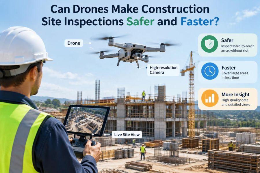
Drones can reduce the need to put an inspector at height or near a hazardous area. They may also shorten the time required to obtain an overview of a large site.
However, a drone introduces different risks: aircraft malfunction, loss of control, distraction, privacy concerns, and interference with site operations. A poorly timed flight over workers or near lifting operations is not a safety improvement.
Speed also has limits. Pre-flight checks, permissions, battery changes, exclusion zones, data transfer, and image review take time. The value comes from replacing inefficient or high-exposure tasks, not from treating flight as effortless.
🧭 4. Start with the inspection question
Before choosing an aircraft or sensor, define the decision the inspection must support. “Fly the site” is too vague to establish useful coverage, image quality, timing, or safety controls.
Useful questions include
- Is the objective to identify visible damage, document progress, measure quantities, or verify access conditions?
- What level of detail is required to make the next decision?
- Which features must be visible, and from what angle?
- Who will review the information and approve any action?
A specific question prevents unnecessary flying and helps distinguish a visual observation from a formal acceptance inspection.
📋 5. Choose the right inspection task
Drones are strongest where a broad view, repeatable imagery, or remote access adds genuine value. They are particularly useful for observing conditions that would otherwise require lengthy access arrangements.
Typical construction uses include roof reviews, façade observations, stockpile documentation, earthwork progress, bridge element viewing, drainage corridor checks, and post-event reconnaissance. A drone can also capture context around a local defect that a close-up photograph may miss.
They are less suitable when an inspector must touch, sound, probe, torque, sample, or closely assess a concealed condition. In those cases, aerial information may guide the field visit rather than replace it.
🧱 6. Know what drones cannot inspect
A camera records surfaces that are visible under available lighting and viewing angles. It cannot directly confirm reinforcement placement behind formwork, internal corrosion, concrete strength, weld quality, compaction, or the condition of hidden drainage.
Even a sharp image can mislead if scale, perspective, shadow, dust, or reflected light obscures a feature. Apparent cracking may be staining, and an apparent gap may be a visual artifact.
Drone imagery is evidence, not a verdict. The responsible engineer or inspector must decide whether the evidence is sufficient and what additional verification is needed.
📷 7. Match the sensor to the job
Most site flights use visible-light cameras because they are efficient for general documentation and visual condition review. A zoom camera can allow closer observation while keeping the aircraft farther from a structure.
Thermal imaging may reveal temperature differences that warrant investigation, such as moisture-related patterns or insulation discontinuities. It does not, by itself, diagnose the underlying defect.
Survey-oriented workflows may use specialized cameras or laser scanning payloads. These systems require careful calibration, control points where appropriate, and an understanding of accuracy limits.
| Tool | Best suited to | Important limitation |
|---|---|---|
| Visible-light camera | Progress records and visible surface observations | Depends on lighting, focus, angle, and resolution |
| Zoom camera | Stand-off viewing of elevated details | Image stability and perspective still matter |
| Thermal camera | Identifying temperature patterns for follow-up | Cannot independently identify every cause |
| Survey payload | Mapping and model inputs | Requires disciplined survey control and processing |
🗺️ 8. Plan the flight path before launch
A planned flight path makes inspection results more complete and repeatable. It identifies where the aircraft will take off, travel, pause for images, maintain separation from obstacles, and land.
For a façade, the plan may use parallel passes at controlled distances. For a stockpile or earthwork area, it may use overlapping passes that support later processing.
Planning also reveals impractical requests early. If a proposed route passes close to cranes, power lines, public roads, or occupied work fronts, the team can revise the objective or choose another method.
🌬️ 9. Read site and weather conditions
Wind, gusts, rain, low cloud, glare, dust, and poor light affect both flight safety and image quality. Conditions that are acceptable for a simple overview may be unsuitable for close structural observation.
Construction sites add temporary obstacles: booms, scaffolds, cables, temporary lighting, netting, concrete pumps, and changing material stacks. A map from last month may not describe today’s flight environment.
A site walk and briefing immediately before the operation are essential. The team should identify active lifts, vehicle routes, emergency work, changing access, and locations where people could enter the flight area.
👷 10. Keep people out of the flight risk area
Good drone operations establish a controlled launch and recovery area, clear communications, and separation from workers who are not involved in the task. The aircraft should not become another uncontrolled overhead hazard.
The size and nature of the control area depend on the site, aircraft, flight path, and applicable rules. It may require coordination with supervisors to pause work locally or redirect pedestrian movement.
Workers should know what is happening, where the aircraft will operate, and who is in charge. Clear notice avoids surprise and reduces the chance of someone walking into the launch area. 🚧
🦺 11. Treat the pilot as part of the safety system
A capable pilot needs more than the ability to make an aircraft move smoothly. They must maintain awareness, recognize hazards, manage batteries, respond to changing conditions, and follow the rules that apply to the location.
The pilot should not be expected to simultaneously watch live imagery, operate controls, monitor workers, speak on the radio, and inspect technical defects. Complex missions benefit from defined roles.
Depending on the operation, these may include a remote pilot, visual observer, site escort, data specialist, and engineering reviewer. Assigning responsibilities before the flight reduces gaps.
📡 12. Maintain communication with site operations
A drone flight must fit within the site’s daily coordination system. The pilot needs to know about crane movements, deliveries, blasting, lifting, concrete pours, emergency access, and work that could be affected by the aircraft.
Likewise, the site team needs a simple way to contact the flight crew. A pre-agreed radio channel, handover point, and stop-work instruction can prevent confusion when site conditions change.
For work near airports, heliports, railways, highways, utilities, or public areas, additional coordination and legal requirements may apply. These must be checked locally rather than assumed.
🔋 13. Manage batteries, failures, and contingencies
Battery condition is a central operational limit, not an afterthought. Flight time is influenced by payload, wind, temperature, maneuvering, and battery health, so mission plans need a practical reserve for landing.
The crew should agree on actions for loss of signal, unexpected people entering the area, sudden weather changes, low battery warnings, and a damaged aircraft. These actions should be simple enough to use under pressure.
A planned landing area is not enough if it becomes blocked by site activity. Identify alternate safe options before takeoff, while conditions are calm.
🔍 14. Capture images that can be interpreted
An image is useful only if the feature is in focus, adequately lit, and shown at a meaningful scale. Random video clips often create large files without providing the details needed for a later decision.
Use an intentional capture sequence: overview images to establish location, medium-range images for context, and closer images for the condition of interest. Where appropriate, include a known reference or coordinate system.
Repeated photographs from similar positions can make changes easier to recognize over time. Consistency is especially valuable for slopes, façades, roofs, and areas affected by ongoing earthworks.
📐 15. Understand measurement and accuracy limits
Drone photographs can support measurements, but a photograph alone does not guarantee survey-grade accuracy. Camera geometry, flight height, overlap, lens calibration, ground control, and processing choices all influence the result.
Photogrammetry creates measurements by identifying common features across multiple overlapping images. It can be highly useful when properly planned, but it should be checked against project survey requirements before being used for payment, setting out, or acceptance.
Report the method and its limitations. This helps prevent an attractive model from being treated as more precise than the workflow can justify.
🧠 16. Turn raw footage into inspection evidence
The work continues after landing. Files should be transferred, organized, reviewed, and connected to the inspection question while the flight details are still fresh.
A practical record identifies the date, location, subject, flight conditions, operator, and notable observations. Marking images with element references or a simple location plan helps reviewers understand what they are seeing.
For recurring inspections, use consistent folders, naming rules, and review templates. This makes historical comparison much easier than searching through unlabelled video files.
🧩 17. Combine aerial and ground inspection
The most reliable workflow often combines drone observations with conventional inspection. A drone can identify areas that need closer attention, while a ground inspection confirms details that are not visually conclusive.
For example, aerial imagery may show staining below a roof penetration. The next step may be a close inspection of flashing, moisture checks, or review of installation records rather than an immediate conclusion about the cause.
This targeted approach can reduce unnecessary access while keeping technical judgment where it belongs: with competent people assessing the evidence.
🏢 18. Use drones effectively on vertical projects
High-rise and building-envelope work can involve persistent access challenges. Drones may document façade installation, roof conditions, upper-level progress, and external interfaces without routine use of ladders or suspended access.
Yet vertical sites are demanding flight environments. Wind can accelerate around corners, signals can be affected by structure, and cranes or hoists may change position during the day.
Close-proximity flights need especially conservative planning. In many cases, a zoom lens and stand-off position offer a safer balance than flying tightly beside glass, cladding, or temporary works.
🌉 19. Apply the method to civil infrastructure
Bridges, retaining walls, culverts, embankments, drainage channels, and road corridors often extend across difficult terrain or active traffic environments. Drones can provide useful context for asset condition and access planning.
They can help inspectors view soffits, slopes, joints, watercourses, and remote approaches, subject to safe access and airspace arrangements. They may also support quick reconnaissance after a storm or other event.
Infrastructure inspections still require asset-specific procedures. A drone image should be incorporated into the owner’s inspection and maintenance system, not stored as an isolated visual record.
🌍 20. Track earthworks and environmental conditions
On large civil sites, repeated aerial coverage can show changing haul roads, drainage paths, stockpiles, exposed soils, and the general sequence of earthmoving work. This broad perspective can improve daily planning.
It may also help teams recognize erosion, ponding, sediment-control concerns, or encroachment near sensitive boundaries. Prompt visibility is useful, but environmental observations still need inspection against the project’s actual controls and permits.
Where quantities are estimated from aerial data, survey and commercial teams should agree on the approved method, assumptions, dates, and confidence needed for the decision.
🔐 21. Protect privacy, security, and project data
A drone can unintentionally record workers, neighboring property, vehicle registrations, security features, or commercially sensitive work. Data governance should be considered before the first flight.
Limit collection to what the inspection needs. Store files in approved systems, define who can access them, and retain or delete records in line with project and organizational requirements.
Security-sensitive sites may impose additional restrictions on flight, imagery, and data transfer. Discuss these controls early, particularly when external pilots or cloud-processing services are involved.
⚖️ 22. Follow aviation rules and site rules
Drone operations are regulated differently across jurisdictions, and requirements can depend on aircraft type, location, airspace, visual line of sight, proximity to people, and the nature of the operation. The pilot and organization must identify applicable rules before flying.
Construction safety rules do not disappear because the aircraft is small. The operation should sit within the project’s risk assessment, permits, induction process, emergency planning, and contractor-management arrangements.
Legal permission and site permission are separate checks. Satisfying one does not automatically satisfy the other.
💰 23. Evaluate value beyond the flight time
The value of a drone is not measured only by how quickly it gets airborne. Consider avoided access work, reduced exposure, earlier detection of issues, improved documentation, fewer repeat visits, and better coordination.
Also consider training, maintenance, insurance, software, permissions, data storage, review time, and the cost of an operation that fails to collect usable data. A low-cost flight can become expensive if it must be repeated.
The best business case is tied to a recurring inspection need and a clear decision process, rather than novelty or impressive visuals.
📊 24. Select between internal and specialist capability
An internal drone team can respond quickly and build familiarity with a project. This can work well for routine progress records and carefully defined site tasks.
A specialist provider may be better for complex airspace, advanced mapping, thermal work, large infrastructure, or missions requiring extensive processing and formal deliverables. Their experience can also help establish robust procedures.
Either approach needs a clear scope. Define deliverables, required detail, safety responsibilities, data ownership, quality checks, and the qualifications needed to interpret results.
🧪 25. Run a controlled pilot before scaling up
Start with one inspection problem that has a known conventional method. Compare the drone workflow with the existing approach in terms of safety exposure, time, completeness, quality of evidence, and follow-up actions.
Do not judge a pilot only by the quality of its images. Ask whether the result changed a decision, eliminated an access task, found an issue earlier, or improved the inspection record.
Document what did not work: gaps in coverage, poor lighting, communications problems, difficult data processing, or confusion about reviewer responsibilities. These lessons are valuable before the program expands.
✅ 26. Build a repeatable inspection procedure
A repeatable procedure turns occasional flights into a controlled engineering support tool. It should be proportionate to the operation, but it should not rely on memory or informal assumptions.
Core procedure elements
- Inspection objective, scope, and acceptance or escalation criteria
- Site risk assessment, airspace review, and coordination plan
- Defined flight area, weather limits, crew roles, and emergency actions
- Image capture plan, file naming, storage, review, and reporting process
- Clear triggers for ground verification or engineering review
Review the procedure as site conditions, regulations, equipment, and project needs change.
🎯 27. The core principle: reduce exposure, preserve judgment
Drones can make construction inspections safer and faster when they remove unnecessary exposure and provide timely, usable evidence. Their greatest strength is often not replacing inspectors, but helping inspectors direct their attention where it matters most.
Success depends on a defined question, competent operation, suitable sensor choice, controlled site coordination, and honest treatment of limitations. Images must flow into an accountable inspection and decision process.
Use drones to extend professional judgment, not to substitute for it. When that principle guides the work, aerial inspection can improve both safety and project understanding. 🛰️👷